Mount Meron
| Mount Meron | |
|---|---|
| Har Merón • Jábal al-Jármaq | |
 Northern slopes of Mt. Meron | |
| Highest point | |
| Elevation | 1,208 m (3,963 ft) |
| Coordinates | 33°00′N 35°25′E / 33.000°N 35.417°ECoordinates: 33°00′N 35°25′E / 33.000°N 35.417°E |
| Geography | |
 Mount Meron | |
Mount Meron (Hebrew: הר מירון, Har Meron; Arabic: جبل الجرمق, Jabal al-Jarmaq)[1] is a mountain in Israel. It has special significance in Jewish religious tradition and parts of it have been declared a nature reserve.
At 1,208 metres (3,963 ft) above sea level, Mount Meron is the highest peak in Israel,[2] though many peaks in the Israeli-occupied area of the Golan Heights and Mount Hermon are higher.
Mount Meron nature reserve
In 1965, an 84000-dunam nature reserve was declared. An additional 1199 dunams were declared part of the reserve in 2005.[3] It is the highest reserve in Israel, at an altitude of 1208 meters above sea level, and the largest reserve in the north of the country.[4]
Religious significance
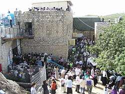
The village of Meron and the tomb of Rabbi Shimon bar Yochai are on Mount Meron. Leading up to the anniversary of his death on Lag B'Omer, thousands of people camp out along the slopes near the tomb, and on Lag B'Omer itself, hundreds of thousands make pilgrimages to celebrate the occasion.
Hiking paths
The mountain has a strong undergrowth and it cannot be walked up from every direction. The main path starts at the northwest side of the Meron village. There is a gate next to the road, with a color-marked path of about 10 km. There is also a path on the west side of the mountain.
Climate
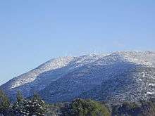
Mt Meron has a Mediterranean climate with hot and dry summers and damp and cool winters. It snows briefly on Mt Meron a few times during every winter. There are 22 days a year with a temperature of 32 °C or higher and 28 days below freezing. Note: the chart is an average of 5 years so the record highs and lows may not be fully accurate.
| Climate data for Mount Meron (2002–2007) | |||||||||||||
|---|---|---|---|---|---|---|---|---|---|---|---|---|---|
| Month | Jan | Feb | Mar | Apr | May | Jun | Jul | Aug | Sep | Oct | Nov | Dec | Year |
| Record high °C (°F) | 17 (63) |
22 (72) |
18 (64) |
26 (79) |
32 (90) |
32 (90) |
33 (91) |
36 (97) |
33 (91) |
28 (82) |
26 (79) |
20 (68) |
36 (97) |
| Average high °C (°F) | 8 (46) |
9 (48) |
11 (52) |
18 (64) |
23 (73) |
27 (81) |
29 (84) |
30 (86) |
27 (81) |
26 (79) |
20 (68) |
12 (54) |
20 (68) |
| Daily mean °C (°F) | 6 (43) |
6 (43) |
7 (45) |
13 (55) |
18 (64) |
21 (70) |
23 (73) |
24 (75) |
21 (70) |
20 (68) |
16 (61) |
9 (48) |
15.3 (59.6) |
| Average low °C (°F) | 4 (39) |
3 (37) |
4 (39) |
8 (46) |
13 (55) |
15 (59) |
17 (63) |
18 (64) |
16 (61) |
15 (59) |
12 (54) |
6 (43) |
10.9 (51.6) |
| Record low °C (°F) | −2 (28) |
−8 (18) |
— | 3 (37) |
7 (45) |
11 (52) |
15 (59) |
13 (55) |
13 (55) |
11 (52) |
5 (41) |
— | −8 (18) |
| Source: "Climate Information for Har Meron, Israel". Weather Base. | |||||||||||||
References
- ↑ "Encyclopædia Britannica: Mount Meron". Retrieved 2008-11-24.
- ↑ Federal Research Division (2004). Israel A Country Study (Paperback ed.). Kessinger Publishing, LLC. p. 8. ISBN 141912689X.
- ↑ "List of National Parks and Nature Reserves" (PDF) (in Hebrew). Israel Nature and Parks Authority. Retrieved 2010-09-27.
- ↑ "Mount Meron reserve" (in Hebrew). Israel Nature and Parks Authority. Retrieved 2010-09-27.
| Wikimedia Commons has media related to Mount Meron. |
| Wikivoyage has a travel guide for Mount Meron. |
| Northern District |
|
|---|---|
| Central District |
|
| Southern District | |
| Eilat Region | |
† Located in the Israeli-occupied territories | |