Muckanaghederdauhaulia

in County Galway, Ireland
Coordinates: 53°20′28″N 9°34′09″W / 53.341125°N 9.569153°W
Muckanaghederdauhaulia (Irish: Muiceanach idir Dhá Sháile[1], meaning "ridge, shaped like a pig's back, between two expanses of briny water[2]") is a 470 acre townland in the civil parish of Kilcummin in County Galway, Ireland. It is in the poor law union of Oughterard in the barony of Moycullen.[1][3]
It was formerly regarded as the longest place name (in English) in Ireland (22 letters), but awareness of longer names has challenged Muckanaghederdauhaulia.[4] There was a hamlet within the townland which had the same name in Irish (Muiceanach idir Dhá Sháile), but a shorter English name, Mucknasalia.[5][6] The 1911 census enumerator spelled it Muckenaghedderdahaulia (23 letters)[7] though the published report uses the 22-letter spelling.[8]
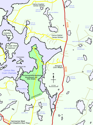
The townland lies on a low, boggy peninsula in Camus Bay and can be reached by turning west from the R336 road at Cinn Mhara, or by going northwest on the R374 road out of Casla, then turning onto Bóthar na Scratóg and going north.[9]
Population
The population recorded in those census reports which provided figures at townland level were as follows:[10][8]
| Census year | 1841 | 1851 | 1861 | 1871 | 1881 | 1891 | 1901 | 1911 |
|---|---|---|---|---|---|---|---|---|
| Population | 103 | 81 | 79 | 80 | 111 | 85 | 101 | 111 |
See also
List of longest placenames in Ireland
References
- 1 2 Muckanaghederdauhaulia at the Irish Placenames Database. Retrieved: 2010-09-30.
- ↑ Ó Máille, T. S. (1955). "Muiceanach Mar Áitainm". Journal of the Royal Society of Antiquaries of Ireland (in Irish and English). Royal Society of Antiquaries of Ireland. 85 (1): 88–93. JSTOR 25509201.
- ↑ Muckanaghederdauhaulia Ordnance Survey Ireland. Retrieved: 2013-11-12.
- ↑ Ireland’s strangest place names Irish Central, 2010-08-03.
- ↑ "Mucknasalia". Placenames Database of Ireland. Retrieved 13 November 2013.
- ↑ "First-edition 6-inch map". Mapviewer. Ordnance Survey Ireland. c. 1840. Retrieved 13 November 2013.
- ↑ "Houses in Muckenaghedderdahaulia (Crumpaun, Galway)". Census of Ireland 1911. National Archives:. Retrieved 13 November 2013.
- 1 2 "Census > 1911 > Ireland > Area, houses, and population, Connaught, Ireland, 1911 Page 86". HISTPOP.ORG. Retrieved 13 November 2013.
- ↑ Muckanaghederdauhaulia Google Maps. Retrieved: 2013-11-12.
- ↑ "Census > 1881 > Ireland > Area, population and number of houses, Vol. IV, Ireland, 1881 Page 96". HISTPOP.ORG. Retrieved 13 November 2013.