Tuam
| Tuam Tuaim | ||
|---|---|---|
| Town | ||
|
High Street, looking east | ||
| ||
|
Motto: "Tuath Thuama go Buan" "Long Live the People of Tuam" | ||
 Tuam Location in Ireland | ||
| Coordinates: 53°30′54″N 8°51′04″W / 53.515°N 8.851°WCoordinates: 53°30′54″N 8°51′04″W / 53.515°N 8.851°W | ||
| Country | Ireland | |
| Province | Connacht | |
| County |
| |
| Municipal District | Tuam | |
| Dáil Éireann | Galway East | |
| Elevation | 44 m (144 ft) | |
| Population (2016)[1] | ||
| • Urban | 9,550 | |
| Eircode (Routing Key) | H54 | |
| Area code(s) | 093 (+35393) | |
| Irish Grid Reference | M436521 | |

| Historical population | ||
|---|---|---|
| Year | Pop. | ±% |
| 1821 | 4,571 | — |
| 1831 | 6,883 | +50.6% |
| 1841 | 6,034 | −12.3% |
| 1851 | 4,929 | −18.3% |
| 1861 | 4,563 | −7.4% |
| 1871 | 4,223 | −7.5% |
| 1881 | 3,567 | −15.5% |
| 1891 | 3,012 | −15.6% |
| 1901 | 2,896 | −3.9% |
| 1911 | 2,980 | +2.9% |
| 1926 | 3,293 | +10.5% |
| 1936 | 4,181 | +27.0% |
| 1946 | 3,868 | −7.5% |
| 1951 | 4,010 | +3.7% |
| 1956 | 4,789 | +19.4% |
| 1961 | 4,732 | −1.2% |
| 1966 | 4,742 | +0.2% |
| 1971 | 4,952 | +4.4% |
| 1981 | 6,093 | +23.0% |
| 1986 | 6,039 | −0.9% |
| 1991 | 5,540 | −8.3% |
| 1996 | 5,627 | +1.6% |
| 2002 | 6,027 | +7.1% |
| 2006 | 6,885 | +14.2% |
| 2011 | 8,242 | +19.7% |
| 2016 | 9,550 | +15.9% |
| [2][3][4][5][6] | ||
Tuam (/ˈtjuːəm/ TEW-əm), Irish: Tuaim ([t̪ˠuəmʲ]) is a town in Ireland and the second largest settlement in County Galway. It is situated west of the midlands of Ireland, approximately 35 km (22 mi) north of Galway city. Human existence in the area dates to the Bronze Age while the historic period dates from the 6th century. The town became increasingly important in the 11th and 12th centuries in political and religious aspects of Ireland. The market based layout of the town and square indicates the importance of commerce.
History
The record of human settlement in Tuam dates back to the Bronze Age when an area adjacent to Shop Street was used as a burial ground. The name Tuam is a cognate with the Latin term tumulus (burial mound). The town's ancient name was Tuaim Dá Ghualann, i.e. the burial mound of two shoulders.
The name probably refers to the high ground on either side of the River Nanny, overlooking a probable fording point over the River Nanny (or Corchra). In 1875, a Bronze Age burial urn was discovered in the area by workmen, dating from c.1500 B.C.[7] An early glass photograph still exists.
The history of Tuam as a settlement dates from the early sixth century. Legend states that a monk called Iarlaithe mac Loga who was a member of a religious community at Cloonfush some 6 km (4 mi) west of Tuam and adjacent to the religious settlement at Kilbannon. Iarlaithe's life became uncertain as he wished to travel. Eventually, Iarlaithe's abbot, Benignus of Armagh told him to "Go, and where ever your chariot wheel breaks, there shall be the site of your new monastery and the place of your resurrection". Iarlaithe's wheel broke at Tuam and he established a monastery there, known as the School of Tuam. As was typical with early settlements in Ireland, religious sites became established first and towns grew around them. Likewise, Tuam grew up around the monastery and has kept the broken chariot wheel as its heraldic symbol.
In 1049, when Aedh O'Connor defeated Amalgaid ua Flaithbertaigh, King of Iar Connacht, the O'Connor kings became kings of Connacht. O'Connor then built a castle at Tuam and made it his principal stronghold. This event was directly responsible for the subsequent rise in the importance of the town. Its position dominated the Iar Connacht heartland of Maigh Seóla.
In the twelfth century, the town became the centre of Provincial power during the fifty-year reign of Tairrdelbach Ua Conchobair (r. 1106–1156). He also brought Tuam its most prominent status as seat of the High King of Ireland which he achieved by force of arms during his long career.
At the Synod of Kells in 1152, the centre of government also became the ecclesiastical centre, as Tuam was erected into an Archbishopric, with Áed Ua hOissín as the first Archbishop.
Tairrdelbach Ua Conchobair, as High King of Ireland from 1128–1156, was a great patron of the Irish Church and it was due to his patronage that Tuam became the home of some masterpieces of 12th century Celtic art, including the Cross of Cong. Tairrdelbach was succeeded by his son Ruaidrí Ua Conchobair, the last native High King of Ireland. In 1164, Ruaidrí had a "wonderful castle" erected, with a large courtyard defended by lofty and massive walls and a deep moat into which the adjacent river was diverted through. This was the first Irish built stone castle.[8] A small part of the castle still stands. Following the destruction of the first Cathedral in 1184, Ruaidrí Ua Conchobair left Tuam and retired to Cong Abbey, where he entrusted the Church valuables from the Cathedral at Tuam into the care of the abbot. This left Tuam as a small settlement and it wasn't until the early 17th century that it began to grow in importance again.
Throughout history, Tuam has been an important commercial centre with fairs and markets being an important part of commerce in the region. One of its fairs dates to 1252 when Letters Patent were granted to Archbishop MacFlynn by Henry III of England. Other fairs were authorised by Charters granted by James VI and I and George III of the United Kingdom.[9]
In July 1920, the town hall and other properties were burned down by armed Royal Irish Constabulary men, after two had been killed in an ambush by the Irish Republican Army near the town the day before.
The Borough of Tuam
On 30 March 1613, Tuam received a royal charter from James VI and I, which enabled the Tuam Parliamentary constituency to send two representatives to Irish House of Commons until its abolition in 1800. The town was laid out as a market town to its present plan with all the streets converging on the central square. The charter also established a formal local council with an elected sovereign and 12 burgesses. The sovereign was sworn into office at the site of the "Chair of Tuam" which is believed to be situated within the remaining tower of Ruaidrí Ua Conchobair's castle. A monumental "Chair of Tuam" was unveiled in May 1980 by the late Cardinal Tomás O'Fiaich.[10]
 Chair of Tuam Monument
 Wall of the "Wonderful Castle"
The High Crosses of Tuam
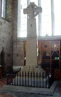
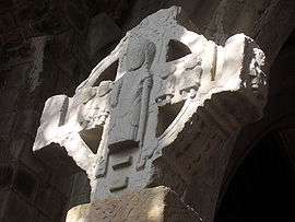
The High Cross of Tuam was erected in 1152 possibly to commemorate the appointment of the first Archbishop of Tuam, Archbishop Áed Ua hOissín. An inscription at the base calls for "A prayer for O'hOisín; for the Abbot; by whom it was made". It is reputed to have been the tallest of the High Crosses of Ireland, but its artistry is scarred by the absence of the top portion of the main shaft.[9] The sandstone Cross was originally erected in proximity to the earliest Cathedral erected in the town, a part of which still remains and is incorporated into St Mary's Cathedral (12th-century red sandstone chancel arch in Irish Romanesque architecture, which is a National monument). The original High Cross or Market cross may have been erected close to what is now the Market Square and High Street.
When the first Cathedral collapsed after being destroyed by fire in 1184, the High Cross was dismantled into pieces, each under different ownership. The archaeologist George Petrie discovered the base of the High Cross c. 1820 and later discovered two other pieces in other locations. The High Cross contains a portion from another High Cross, the ringed cross-section on top. In addition to the Market Cross, it is likely that there were at least four other carved stone crosses from the Connor's reign in the town. An area close to the town Square, known as the Shambles, which continued to function as a market place until recently, was at one point the location of the Market Cross until 1721.[11]
The Cross was brought to Dublin for the Great Exhibition of 1852. However, prior to its return to Tuam, a disagreement arose between the two Churches. Catholic Archbishop Dr. John MacHale claimed the Cross rightfully belonged to Catholics, with Dean Charles Seymour of the Church of Ireland asserting a Protestant claim. Agreement was reached with the Cross erected half way between both Cathedrals and positioned so that it was visible from all main streets of the town. It was situated in the Square in the town centre in 1874.
By the late 1980s, it was evident that the decorative stone carving of the Cross was deteriorating due to weathering and pollution. Experts thought that there was a danger from traffic passing nearby. After lengthy discussions, the Office of Public Works removed the monument from the Square in April 1992. Following cleaning and minor restoration, the High Cross was re-erected in the south transept of St. Mary's Cathedral, where it is now situated, in proximity to its original location. St. Mary's Cathedral also houses the shaft of a third Cross fashioned from limestone. It is thought that all of the High Crosses would have marked the boundaries of the monastic section of Tuam.
Coat of arms
The red latin cross is representative of Tuam's importance as an ecclesiastical centre. The double green flaunches at the sides, represent the two hills or shoulders of Tuam's ancient name, Tuaim Dhá Ghualainn. The two crowns recall the High Kings, Tairrdelbach and Ruaidrí, who were based in Tuam. The broken chariot wheel being a reminder of the foundation of the monastic town when Iarlaithe's chariot wheel broke. The motto of the town, Tuath Thuama go Buan, translates as "Long Live the People of Tuam".[12]
Bon Secours Mother and Baby Home
The Bon Secours Mother and Baby Home, St. Mary's Mother and Baby Home,[13] or simply The Home, was a maternity home for unmarried mothers and their children that operated between 1925 and 1961 in Tuam, Ireland. It was run by the Bon Secours religious order. From its construction in the mid-19th century until the early 20th century, what became The Home's building served as a workhouse for the poor.
Climate
| Climate data for Tuam (Airglooney) (1981-2010) | |||||||||||||
|---|---|---|---|---|---|---|---|---|---|---|---|---|---|
| Month | Jan | Feb | Mar | Apr | May | Jun | Jul | Aug | Sep | Oct | Nov | Dec | Year |
| Average high °C (°F) | 8.7 (47.7) |
9.0 (48.2) |
10.7 (51.3) |
13.0 (55.4) |
15.7 (60.3) |
18.3 (64.9) |
19.4 (66.9) |
19.3 (66.7) |
17.3 (63.1) |
14.1 (57.4) |
11.4 (52.5) |
8.9 (48) |
13.82 (56.87) |
| Daily mean °C (°F) | 5.2 (41.4) |
5.5 (41.9) |
6.9 (44.4) |
8.4 (47.1) |
10.9 (51.6) |
13.4 (56.1) |
15.1 (59.2) |
14.9 (58.8) |
12.9 (55.2) |
10.1 (50.2) |
7.8 (46) |
5.5 (41.9) |
9.72 (49.48) |
| Average low °C (°F) | 1.7 (35.1) |
2.0 (35.6) |
3.1 (37.6) |
3.9 (39) |
6.1 (43) |
8.5 (47.3) |
10.8 (51.4) |
10.6 (51.1) |
8.6 (47.5) |
6.0 (42.8) |
4.2 (39.6) |
2.0 (35.6) |
5.63 (42.13) |
| Mean monthly sunshine hours | 42.70 | 61.82 | 93.31 | 142.80 | 169.26 | 144.00 | 126.79 | 124.93 | 104.70 | 86.18 | 52.80 | 33.79 | 1,183.08 |
| Source: Met Éireann[14] | |||||||||||||
Transport

- Tuam is served by the N17 road (Galway to Sligo) and the N83 road (to Ballyhaunis) as well as R332 and R347. A bypass of the N17, avoiding congestion to the west of the town, involved acquisition of land by Galway County Council in late 2006. The design of this road includes a bridge over the existing closed railway lines, allowing for future re-opening of the line. As of 2015, the M17 road from Gort to Tuam is under construction, with opening planned for 2018.
- Tuam railway station is located on the disused railway line from Athenry to Sligo. There was a part-successful campaign by West-on-track to have the line reopened as a Western Railway Corridor which was recognised in the Transport21 project. Construction work to reopen the line between Ennis and Athenry was completed in 2009.[15] Passengers trains run between Limerick and Athenry (where connections to Galway can be made) with further extensions planned. Tuam railway station opened on 27 September 1860, closed to passenger traffic on 5 April 1976 and finally closed altogether on 18 December 1978.[16] The railway lines were heavily used by trains transporting sugar beet to the Irish Sugar Factory (Comhlucht Siúcra Éireann Teo.) formerly located off the Ballygaddy Road. The railway line was used during the filming of "The Quiet Man", and can be seen when John Wayne disembarks at Ballyglunin, around 6 km (4 mi) from Tuam.
- Tuam is served by Bus Éireann routes 25, 52, 64, 417, 429 and 433.
Education

Tuam is the location of several second level educational institutions, St. Jarlath's College, Archbishop McHale College, Presentation College Currylea and St Bridget's Secondary School. St. Patrick's College (formerly Tuam Christian Brothers School), was amalgamated with St. Jarlath's College in June 2009. There are 4 main primary schools, Mercy Convent and the Presentation Convent for girls, St. Patrick's Primary Schoolwww.patstuam.ie for boys, and Gaelscoil Iarfhlatha, an Irish language primary school (bunscoil lán Ghaeilge) for both boys and girls.
Religion
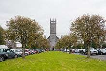
Tuam has two cathedrals, Cathedral of the Assumption of the Blessed Virgin Mary, Tuam, which is the seat of the Roman Catholic Archdiocese of Tuam, and the Church of Ireland's St. Mary's Cathedral. The town's patron saint is Iarlaithe mac Loga.
Sport
Gaelic Games
The town has a strong Gaelic Athletic Association tradition: Tuam Stars, founded in 1888, is the local Gaelic football team, and are one of Galway's most successful clubs. From the period 1953–1960, Tuam Stars were the dominant force in the Galway County Championship winning seven titles in a row, with players such as Seán Purcell and Frank Stockwell playing at the time. St. Jarlath's College, Tuam has won the Hogan Cup (National Championship for secondary schools) a record 12 times since the competition began in 1946. The parish has a second Gaelic football club, Cortoon Shamrocks, founded in 1888.
Tuam Stadium St Jarlath's Park was officially opened on 21 May 1950 by the Archbishop of Tuam, Rev. Dr. Walsh. It became "the home of Galway football" and has a long history and tradition, having hosted many important matches including Connacht Senior Football Finals. A new €5 million redevelopment project has been granted planning permission including a new 6,400 capacity stand and ancillary facilities. Tuam Stadium Development Committee is currently fundraising for this ambitious project.
Soccer
There are also two local soccer teams: Tuam Celtic A.F.C., founded in 1974 who play their home matches at Celtic Park, Cloonthue. Dynamo Blues, founded in 1978 whose home is the College Field, Athenry Road.
Rugby
Rugby, while third to football and soccer, has long been popular in Tuam. Tuam RFC draws its members from Tuam and its hinterland and plays its home matches at Garraun Park, Dublin Road.
Golf
Tuam Golf Club was established on 17 October 1904 with the original clubhouse situated at Cloonascragh on the Athenry Rd. Later, the club relocated to Mayfield, on the Dunmore Rd., in 1937 due to a deterioration of the Cloonascragh course. Although, in March 1940 a new club called the Commercial Golf Club was established, which renovated the course and remained for many years at Cloonascragh. World-renowned Irish golfer Christy O'Connor Snr joined Tuam Golf Club as club professional in 1948. To develop an 18 hole course, Tuam Golf Club relocated to Barnacurragh (close to the original Cloonascragh course) and a new clubhouse and the first 9 holes were opened in 1975. 18 holes came into play by 1979, on the course designed by golf architect, Eddie Hackett. Improvement works have continued over the years with Christy O'Connor Jnr advising the club on course improvement works. The most recent design work have been under the guidance of golf architect Ken Kearney.
Athletics
Tuam Athletics Club is a thriving club, which, in addition to its many juvenile training sessions, holds training sessions and meets for adults.
Gymnastics
Tuam All Star Gymnastics Club, runs classes from its Athenry Road base. The club boasts All – Ireland success, taking its first national title in 2002 and club members have competed internationally. The club also takes part in local St Patrick's Day parades and Tuam's Summer arts festival and many other local events. In 2010 the club reached the semi-finals of the All Ireland Talent Show.
Swimming
Tuam Swimming Club has been promoting swimming in the Tuam area since the its foundation in 1950. Today there are approximately 100 swimmers regularly training. After a number of years out of the national limelight Tuam swimmers are once again beginning to make an impression in swimming galas at local and provincial level. The Club season runs from September to the end of June each year.
Culture
The Arts
The Marian Choral Society was formed in 1974, with an initial aim to sing church and secular music. Then, in 1977, the first musical production was staged, with an annual show each October since. The society has a proud record stretching back to 1977 of never repeating a show.
Earwig! Tuam Community Arts Group was formed in October 2003 to provide Tuam and its surroundings with an outlet for its creative talent. Since 2003, the group has organised the Earwig! Tuam Arts Festival which includes visual arts, theatre, drama, spectacle, children's arts workshops, street performance and music. The festival has now established itself as one of the highlights of the West of Ireland's arts scene. Earwig! also takes part in the annual St. Patrick's Day parade in Tuam with an emphasis on bringing movement and spectacle.
Music
Tuam is long known to have a vibrant music scene. While The Saw Doctors are perhaps the town's most famous band, many more bands and performers from the town have gained popularity both nationally and internationally. In the 60's, Tuam was once known as 'The Showband Capital of Ireland' because at one time, no less than six top class showbands called the well known market town home. The best known of these was the Johnny Flynn Showband, a musical combination with its roots firmly in the tradition of the Tuam Brass Band.[17] In 2009, a compilation CD of over 50 original songs, all by musicians from Tuam, entitled 'Songs from the Broken Wheel' was released. Tuam is referenced in The Rocky Road to Dublin, popularised by The Dubliners and various other Irish folk artists.
The Old Tuam Society
The Old Tuam Society was founded 1942 with a view to preserving a record of the town's illustrious past and to foster and promote that knowledge for the benefit of future generations. The new society was open to "all those who are interested in its aims, namely the preservation and study of the antiquities of Tuam and district." Young and old were welcome as well as "members of the fair sex." An invitation was issued to Tuam people scattered far and wide to join the circle for an annual subscription of two shillings and six pence.[18] The society publish an annual called JOTS (Journal of the Old Tuam Society).
Market Day
The Tuam market was revived in 2006 by the Energise Tuam, a group which organised by local traders in conjunction with Tuam Chamber of Commerce in an effort to promote shopping in the town. It currently takes place on the last Saturday of every month, at the plaza in front of Tuam Shopping Centre. In the future, Galway County Council has earmarked the Shambles car park nearer the town centre as the market's location on a permanent basis.[19]
Media
The Tuam Herald is a weekly local newspaper, founded in 1837 by Richard Kelly, which serves the town of Tuam and the surrounding areas of north County Galway, south Mayo and west Roscommon. It is County Galway's oldest newspaper and the fifth oldest newspaper in the Republic of Ireland.[20]
Public Library
Tuam Library is situated on High Street, nestled Temple Jarlath and St. Mary's Cathedral. The library contains a diverse stock of over 45,000 books for children and adults. A collection of local history books are available for reference along with copies of the Tuam Herald and 1901/1911 census on microfilm. Free internet access and Wi-Fi are also available to library users.
International relations
Twin towns
Tuam is twinned with:
 Straubing, Germany
Places of interest
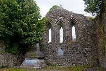
- Temple Jarlath at High Street, marks the site of the earliest monastic settlement in Tuam, established by St. Jarlath circa 526–527 AD. Temple Jarlath is situated near the town centre. It marks the site of an early monastic settlement dedicated to St Jarlath, Tuam's 6th century patron. The surviving ruins include a late 13th-century parish church containing an east window in Transitional style.
- The Mill Museum – This undershot water wheel mill found off Shop Street, which traces its origin to the 17th century, was in operation until 1964. It is the only preserved corn mill in the West of Ireland. The Mill Museum complex, located beside the river Nanny, consists of the restored corn mill with operating water wheel, an audiovisual museum and Tourist Information Office.
- Cathedral of the Assumption – Roman Catholic Archdiocese of Tuam in County Galway.

- St. Mary's Cathedral – The Church of Ireland Cathedral was built 1861–1878, incorporating a 12th-century arch and sanctuary, and a 14th-century chancel.[21]
- Castlehacket – a castle near Tuam, was home of the Hacket family at first; later of the Kirwans after the Cromwellian settlement. Many scenes from the 1969 movie Alfred the Great were filmed in the environs of Castlehacket and Knockma.[22]
Notable people
in chronological order:
- Amergin of Maigh Seóla, father of Saint Finbar
- Rúaidhri Ua Flaithbheartaigh, King of Iar Connacht
- Tairrdelbach Ua Conchobair, King of Ireland
- Áed Ua hOissín, (Hugh O'Hession) – first Archbishop of Tuam
- Seán Ó Maolalaidh, Chief of the Name (Lally)
- Tomás Ó Maolalaidh, Bishop of Clonmacnoise and Archbishop of Tuam
- Sir Gerard Lally, an Irish Jacobite and French military officer
- James Ellis Fleming, claimant to title of 20th Baron Slane
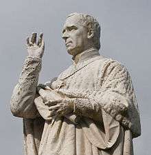
- John MacHale, Archbishop of Tuam
- Andrew Egan, architect and "Builder of Tuam"
- Colonel Patrick Kelly, American Civil War Commander
- Sir Theobald Burke, 13th Baronet
- Thomas Henry Burke, Permanent Under Secretary at the Irish Office, was killed during the Phoenix Park Murders
- Augustus Nicholas Burke, artist
- Mark F. Ryan, author and nationalist
- Edward "Doc" Byrne, journalist, author and editor of The Freeman's Journal newspaper
- Peter Maher, Heavyweight Champion boxer
- Michael Moran Republican
- Robert Malachy Burke, Christian Socialist, better known as Bobby Burke.
- Jack Mangan, Gaelic footballer
- Seán Purcell, Gaelic footballer
- Frank Stockwell, Gaelic footballer
- Tom Murphy, playwright
- Bernard Davenport, Retired Ambassador to Argentina, also the Holy See
- Mark Killilea, Jnr, Fianna Fáil politician
- Mike Cooley, Trade union activist
- Professor Frances P. Ruane, director of the Economic and Social Research Institute (ESRI)
- Paddy McHugh, Independent politician
- Finian McGrath, Independent politician
- Raymond Deane, modernist classical composer
- Brian Talty, Gaelic footballer
- Blaze X, Punk band
- The Saw Doctors. The N17 road does in fact pass through the town, as their famous song "N17" suggests.
- Paul Cunniffe, singer-songwriter, musician
- Colm Keaveney, politician
- Jarlath Fallon, Gaelic footballer
- Stephen Moore, Australian International rugby player
Miscellanea
- Tuam is officially a town despite claims for city status based on the presence of a cathedral (actually has two), one of the original definitions of what constitutes a city.
- The Annals of the Four Masters record that in 1488 A whirlwind attacked a number of persons, as they were cutting turf on the bog of Tuaim-Mona, which killed one of them, and swelled the faces of the rest; and four others were killed by the same wind in Machaire-Chonnacht.
- The "Rocky Road to Dublin" is a song about a man's experiences as he travels to Liverpool, England from his home in Tuam.
Roads named after Tuam
- Tuam Street, Christchurch, New Zealand is named after the Irish (Anglican) bishopric of Tuam. It was named by Captain Joseph Thomas, the Canterbury Association's Chief Surveyor and his assistant Edward Jollie.[23] There are also Tuam Streets located in Concord, a suburb of Sydney and Victoria Park, a suburb of Perth, Australia.
- Tuam Street, in Houston, Texas, US, is named in honour of Richard W. "Dick" Dowling.[24]
- Tuamstraße (Tuam Street) is located in Straubing, Germany, and is named in honour of the twinning of the two towns.
- Tuam Road is located Plumstead, in the Borough of Greenwich in London, SE18.[25]
See also
- Roman Catholic Archdiocese of Tuam
- List of towns and villages in Ireland
- Diocese of Tuam, Killala and Achonry
References
- ↑ AIRO - Census 2016 - Preliminary Results
- ↑ "Census for post 1821 figures.". Cso.ie. Retrieved 19 March 2014.
- ↑ http://www.histpop.org
- ↑ "NISRA – Northern Ireland Statistics and Research Agency (c) 2013". Nisranew.nisra.gov.uk. 27 September 2010. Retrieved 19 March 2014.
- ↑ Lee, JJ (1981). "On the accuracy of the Pre-famine Irish censuses". In Goldstrom, J. M.; Clarkson, L. A. Irish Population, Economy, and Society: Essays in Honour of the Late K. H. Connell. Oxford, England: Clarendon Press.
- ↑ Mokyr, Joel; O Grada, Cormac (November 1984). "New Developments in Irish Population History, 1700–1850". The Economic History Review. 37 (4): 473–488. doi:10.1111/j.1468-0289.1984.tb00344.x.
- ↑ A Brief History of Tuam. A Town of Two Cathedrals. 2006
- ↑ The Gentleman's Magazine. A. Dodd and A. Smith. 1823. p. 333.
- 1 2 Tuam Official Guide c.1958
- ↑ "Tuam History Tuam Galway Tuam County Galway Tuam Ireland Tuaim County Galway". Tuam-guide.com. Retrieved 19 March 2014.
- ↑ Archived 10 February 2009 at the Wayback Machine.
- ↑ Glimpses of Tuam Since the Famine, J.A. Claffey, ISBN 978-0-9530250-0-8, 1997, Publisher: Old Tuam Society
- ↑ McNamara, Denise (13 February 2014). "Campaign to recognise 800 dead Tuam babies". Connacht Tribune. Retrieved 7 June 2014.
- ↑ Met Éireann
- ↑ "West=On=Track". Westontrack.com. Retrieved 19 March 2014.
- ↑ "Tuam station" (PDF). Railscot – Irish Railways. Retrieved 24 November 2007.
- ↑ "Johnny Flynn Showband". Irish-showbands.com. Retrieved 19 March 2014.
- ↑ The Tuam Herald, 26 September 1942
- ↑ Archived 21 July 2011 at the Wayback Machine.
- ↑ Archived 19 October 2010 at the Wayback Machine.
- ↑ Galloway, Peter (1992). The Cathedrals of Ireland. Belfast: The Institute of Irish Studies. pp. 210–213. ISBN 0-85389-452-3.
- ↑ Murphy, Mary J. (2008) Viking Summer: the Filming of MGM's "Alfred the Great" in Galway in 1968 ISBN 978-0-9560749-0-4. Hardcover:130 pages, ( Nov 2008). Knockma Publishing.
- ↑ Christchurch street names R Archived 30 May 2008 at the Wayback Machine.
- ↑ "Dick Dowling Statue, First Public Monument in Houston, Texas". Texasescapes.com. Retrieved 19 March 2014.
- ↑ "Tuam Road Guide | Tuam Road, London SE18 | Nearby hotels, shops and restaurants". LondonTown.com. 21 October 2013. Retrieved 19 March 2014.
External links
| Wikimedia Commons has media related to Tuam. |
 "Tuam". Encyclopædia Britannica. 27 (11th ed.). 1911.
- Google Maps Streetview
- Tuam Athletics Club
- Tuam Chamber of Commerce
- Tuam Rugby Club
- Tuam Golf Club
- Tuam Herald
- Energise Tuam
- Tuam Stadium
- Tuam.pl -> The Polish-English portal for Tuam society
- The Heritage Council: History of Tuam
- e-TUAM.info :: First Open Information Board
- Tuam – Old Cathedral City
- The Tuam Guide
- UCC documents of High Cross
- Tuam Town