Musakhel District, Pakistan
| Musakhel موسىٰ خيل | |
|---|---|
| District of Balochistan | |
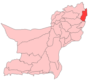 Map of Balochistan with Musakhel District highlighted | |
| Country |
|
| Region | Balochistan |
| District | Musakhel District |
| Union Councils | 17 |
| Mauzas | 71 |
| Government | |
| • NA | 263 |
| • MNA | Molana Ameer Zaman |
| • Political Party | JUI-F |
| Area | |
| • Total | 5,728 km2 (2,212 sq mi) |
| Population | |
| • Total | 1,34,056 (Census 1,988) |
| Time zone | PST (UTC+5) |
| Area code(s) | Post Code : 84700 |
Musakhel (Pashto: ضلع موسی خیل ) is a district of Balochistan (also called District Musakhel or Musakhel District or Musakhel Balochistan or Balochistan's Musakhel or District Musakhel Balochistan or Musakhel District of Balocistan) in the northeast of the Balochistan province of Pakistan.
After the first phase of the Afghan war of 1878-79 AD, the British took control of the northern areas of Balochistan under the Treaty of Gandamak. During 1879-84 AD, efforts were made to extend the British influence over the Khetrans and Musakhels of the, now Musakhel, territory. The Musakhels took part in outrages committed by the Kakars under Shah Jahan in 1884, but surrendered to the British government on the conclusion of the expedition in the same year. On 1 November 1887, the whole area was declared part of British India. Zhob agency was formed in 1890 and Musakhel territory was annexed to it. Musakhel was made a tehsil in 1892 and was transferred to Loralai district in October 1903.
In 1905, the Musakhel tehsil comprised 61 villages and the total population, according to 1901 census, was 15,537 (8,374 males and 7,163 females). The principal tribes represented were: Isot Afghans (1,941); Jafar Afghans (1,026); Panri Afghans (10,144) including the Musakhel clan (9,748) the principal divisions of which were the Belkhel (7,662) and Laharzai (2,086); and Saiads (271). The chief language spoken was Pushto.Musakhel remained a tehsil of Loralai district till 1 January 1992 when it was notified as a district as a result of splitting Loralai district into 3 districts, Loralai, Musakhel, and Barkhan. Although Musakhel is an old human settlement there is no remarkable archaeological site.
Geography
District Musakhel is located in north-eastern border of Balochistan and bordering to Khyber Pakhtunkhwa and Dera Ghazi Khan, Punjab. The total area of the District comprises on 7,552 km². The headquarters of the district is MusaKhel.
Administrative divisions
The district of Musakhel is divided into four tehsils:
Tribes
The main tribes of the district are Musakhels.
Language
According to the United Nations, in 1981 over 85% of households spoke Pashto, 7.2% spoke Jafferki and 7.8% spoke Balochi. Seraiki is commonly spoken in the region as well.
Temperature
The climate of Musakhel, located 1,200-2,400 meters above sea level, is semi-arid. It can be placed in the "warm summer and mild winter" temperature region.The summer is hot with mean temperatures ranging from 21 C to 32 C. June is the hottest month when maximum temperature does exceed 32 C and occasionally rises above 38 C. Summer is longer than winter and lasts for about 7 months (April–October). In winter the temperature drops below 21 C, but in the coolest month (January) the mean monthly temperature drops below 10 C. The mercury may touch the freezing point during cold spells.
Notes
External links
| Wikimedia Commons has media related to Musakhel District, Pakistan. |

Coordinates: 30°55′08″N 69°51′36″E / 30.919°N 69.86°E