Zhob District
| Zhob ژوب | |
|---|---|
| District | |
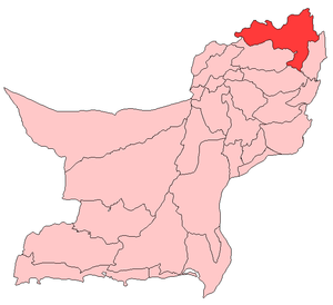 Map of Balochistan with Zhob District highlighted | |
| Country | Pakistan |
| Province | Balochistan |
| Headquarters | Zhob |
| Government | |
| • District chairman | Abdul saleem Mandokhail |
| Area | |
| • Total | 16,000 km2 (6,000 sq mi) |
| Population | |
| • Total | 400,000 in 2,011 |
| Time zone | PKT |
| Number of Tehsils | 5 |
| Main Language(s) | Pashto[1] |
Zhob (Urdu: ژوب) is a district in the north west of Balochistan province of Pakistan. Zhob District is a Provincially Administered Tribal Area. It is subdivided into three subdistricts: Ashwat, Zhob, Qamar Din Karez and Sambaza. The population of Zhob District is estimated to be over 400,000 in 2011. Zhob River is used for irrigation in the Zhob District.
Administration
There are currently four tehsils in Zhob District.[2] and Sherani New District
Population
The vast majority of the population of Zhob district is Pashtun. The indigenous tribes of Zhob include the Mandokhail, [Khosti ]Sherani, Kakar, ], Harifal, Lawon and Babar. Currently a large number of IDPs have been settled within the confines of the District as part of the evacuation from Operation Zarb-E-Azb taking place to the north of Zhob.
References
Bibliography
- Pakistan Narcotics Control Board (1986), National survey on drug abuse in Pakistan, The University of Michigan
External links
| Wikimedia Commons has media related to Zhob District. |

Coordinates: 31°10′N 68°50′E / 31.167°N 68.833°E