Musi River (Indonesia)
| Musi River | |
|---|---|
|
Ampera Bridge over the Musi River | |
| Country | South Sumatra, Indonesia |
| Basin | |
| Main source | Barisan Mountains, Kepahiang, Bengkulu |
| River mouth | Bangka Strait, South China Sea, South Sumatra |
| Physical characteristics | |
| Length | 750 km (470 mi) |
| Features | |
| Average depth | 6.5 m (21 ft) |

The Musi River is located in southern Sumatra, Indonesia.
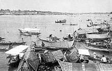
The river roughly flows from south-west to north-east, from Barisan Mountains range that formed the backbone of Sumatra, in Kepahiang, Bengkulu, to the Bangka Strait that formed the extension of South China Sea. It is about 750 kilometers long, and drains most of South Sumatra province. After flowing through Palembang, the provincial capital, it joins with the several other rivers, including the Banyuasin River, to form a delta near the city of Sungsang. The river, dredged to a depth of about 6.5 meters, is navigable by large ships as far as Palembang, which is the site of major port facilities used primarily for the export of petroleum, rubber, and coal.
This river system, especially around the city of Palembang, was the heart of eponymous 7th to 13th century Srivijayan empire. The river mouth was the site of the SilkAir Flight 185 plane crash which killed all 104 passengers and crew on board in 1997.
Gallery
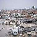 The Musi River and Palembang
External links
 Media related to Musi River at Wikimedia Commons
- Banyuasin Musi River Delta conservation information from the ARCBC
Coordinates: 2°20′37″S 104°55′21″E / 2.34361°S 104.92250°E