Mylor Creek
Coordinates: 50°10′50″N 5°04′07″W / 50.18047°N 5.06865°W
Mylor Creek (Cornish: Pol Scathow, meaning creek of boats) is a tidal ria in south Cornwall, United Kingdom. It is a tributary of Carrick Roads, the estuary of the River Fal and is situated approximately six miles (10 km) south of Truro and two miles (3 km) north of Falmouth .[1]
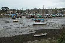
The creek is in Mylor civil parish[2] and forms an inland tidal lake. It is approximately 800 feet (240 m) at its widest point and just over a mile (1.8 km) long from its tidal limit at Mylor Bridge to its mouth at Mylor Churchtown where it discharges into Carrick Roads.[1]
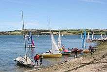
Carrick Roads and Cornwall's English Channel coast are popular for yachting and dinghy racing. Restronguet Sailing Club (which takes its name from Restronguet Creek a mile to the north) has its base at Mylor Harbour,[3] a large yacht marina immediately north of Mylor Churchtown[4]
Locations
- Normal Tidal Limit (NTL) at Mylor Bridge coordinates 50°11′02″N 5°04′38″W / 50.18396°N 5.07727°W grid reference SW 803 361
- Mouth (Mylor Harbour) coordinates 50°10′44″N 5°03′13″W / 50.17882°N 5.05369°W grid reference SW 821 354
References
Cornwall Portal | |
| Unitary authorities | |
| Major settlements |
|
| Rivers | |
| Topics | |