N'guigmi
| N'guigmi Nguigmi, Ngigmi | |
|---|---|
|
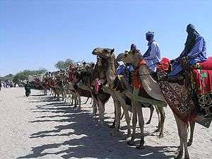
Camel riders line up outside the residence of the traditional chief of Nguigmi | |
 N'guigmi Location of N'guigmi | |
| Coordinates: 14°15′10″N 13°06′39″E / 14.25278°N 13.11083°ECoordinates: 14°15′10″N 13°06′39″E / 14.25278°N 13.11083°E | |
| Country | Niger |
| Region | Diffa Region |
| Department | N'guigmi Department |
| Commune | Nguigmi |
| Elevation | 297 m (977 ft) |
| Population (2011)[1] | |
| • Total | 77,748 |
| [2] | |

N'guigmi is a city and Commune of fifteen thousand in the easternmost part of Niger, very near to Lake Chad – lying on its shore until the lake retreated. It is a crossroads for the traditional camel caravans of the Toureg and for traders plying North and South across the Sahara.
N'guigmi is a military centre for the region, a centre for the salt trade from Kaourar and is the last stop on the road to Chad. It is "the end of the road" and marks the end of the paved section of the Nigerien Route Nationale 1, although the sections past Diffa are notorious for their poor condition.[3] Two unpaved highways or caravan routes connect to N'guigmi from the north, providing the main road route between Chad and Niger, and one of two land routes to the Kaourar Oasis town of Bilma.
The town lies at the mouth of the Dilia Bosso, an ancient river valley and seasonal wash that runs from the Termit Massif over 200 km to the northwest to what was the shore of Lake Chad as recently as the mid 20th century. The town was then a centre of Kanuri fishing communities. By the 2000s, even during the rainy season, the nearest access to water was at the village of Doro (a Beri-beri name for "Fishing port") 45 km southwest of N'guigmi. During the Sahel drought of the mid-1970s the shore was 85 km away from N'guigmi in Chad.[4]
The town is the seat of the Department of N'guigmi, one of three in Diffa Region, which includes the entire north of the Region. N'guigmi is home to a large settlement of Kanuri people, as well as settled members of the traditionally pastoral Wodaabe-Fulani and Daza/Toubou ethnic groups.
References
- ↑ Population figures from citypopulation.de, citing (2001) Institut National de la Statistique du Niger.
- ↑ Nguigmi, Niger Page. Falling Rain Genomics, Inc. 1996–2004
- ↑ See Geels. 2005 photographs from a Dutch travel writer are posted here, and here
- ↑ Geels (2006) pp.236–237
- Decalo, Samuel (1997). Historical Dictionary of the Niger (3rd ed.). Boston & Folkestone: Scarecrow Press. ISBN 0-8108-3136-8.:p.225
- Geels, Jolijn (2006). Niger. Chalfont St Peter, Bucks / Guilford, CT: Bradt UK / Globe Pequot Press. ISBN 978-1-84162-152-4.:pp.232–237