National Highway 66 (India)
| ||||
|---|---|---|---|---|
.jpg) | ||||
| Route information | ||||
| Length: | 1,622 km (1,008 mi) | |||
| Major junctions | ||||
| North end: | Panvel, Maharashtra | |||
|
NH 48 in Panvel | ||||
| South end: | Kanyakumari, Tamil Nadu | |||
| Location | ||||
| States: |
Maharashtra: 482 km (300 mi) Goa: 139 km (86 mi) Karnataka: 280 km (170 mi) Kerala: 669 km (416 mi) Tamil Nadu: 56 km (35 mi) | |||
| Primary destinations: | Panvel - Ratnagiri - Sindhudurg - Panaji - Udupi - Mangalore - Kasaragod - Kannur - Kozhikode - Ponnani - Kochi - Alapuzha - Kollam - Trivandrum - Kanyakumari | |||
| Highway system | ||||
| ||||

National Highway 66, commonly referred to as NH 66 (previously known as NH 17), is a busy National Highway in India that runs roughly north–south along the western coast of India, parallel to the Western Ghats. It connects Panvel (south of Mumbai city) to Kanyakumari, passing through the states of Maharashtra, Goa, Karnataka, Kerala and Tamil Nadu. The highway is undergoing a major overhaul in Karnataka, where the state government has accepted the NHAI's request of international standard, 60-metre-wide national highway with grade separators.[1] The complete stretch from the Goa border (near Karwar) to the Kerala border (near Talapady) is being widened to four lanes, with space to accommodate future expansion to six lanes.[2] There was protests for a narrower stretch from the people who will lose lands, but the Karnataka government has not heeded to the public protests.
But, road widening in other states such as Kerala and Goa has not started and Kerala has requested for a narrower 45 metre stretch in the state. Initially Kerala demanded for a 30-metre-wide highway, but NHAI threatened to stop work in the state and concentrate on the other states. Widening of this highway into a 60-meter wide, 4-lane, international standard highway is in progress in Karnataka and Maharashtra. Maharashtra section of this highway will be converted into a Flexible pavement (Asphalt) road with 4-lane.[3]
Ministry of Road Transport & Highways, Government of India has proposed a Greenfield (i.e., new and parallel) access controlled Expressway Corridor connecting port cities of Mangalore-Karwar-Panaji as part of Indian National Expressway Network.[4] This expressway will be parallel to NH-66 and will be located majorly in Coastal Karnataka. Expressway is expected to be a 6/8 lane access-controlled 3D Right of Way designed Expressway.
Route
It starts at Panvel, at the junction of National Highway 4 (NH 4), and ends at Kanyakumari. NH-66 mainly traverses through the west coast of India, sometimes touching shores of Arabian sea. The NH66 touches the Arabian Sea at Maravanthe in Karnataka, Thalassery, Alappuzha and Kollam in Kerala. It passes through the Indian states of Maharashtra, Goa, Karnataka, Kerala and Tamil Nadu.
The National Highway 66 connects cities and towns of different states as follows: Panvel, Pen, Mahad, Khed, Chiplun, Sangameshwar, Hatkhamba (Ratnagiri), Lanja, Rajapur, Kankavli, Kudal, Sawantwadi, Panaji, Canacona, Margao, Karwar, Kumta, Honnavar, Bhatkal, Kundapura, Udupi, Surathkal, Mangalore, Uppala, Kasaragod, Taliparambu, Kannur, Thalassery, Vatakara, Kozhikode, Kottakkal, Valanchery, Ponnani, Chavakkad, Kodungallur, North Paravur, Kochi, Alappuzha, Kollam, Thiruvananthapuram, Kanyakumari.
Road condition
The NHAI has got approval to upgrade complete stretch of highway from start to end to 4-lane highway, which will be 60 metres and grade separated. Out of four states through which highway goes through Karnataka and Maharashtra have got approval from centre for the 60 metre wide highway. Kerala and Goa have requested for narrower width of 45 metres and there is protest against the highway widening in these states.[5][6] NHAI feels the Kerala state government was lethargic in acquiring land. The four-laning of NH-66(Mumbai- Kanyakumari) has been completed till Thalapadi in Karnataka-Kerala border and only its stretch in Kerala is pending. NHAI does not have any immediate plan to widen this highway in Kerala and closed its Kozhikode office, though NH-66 has one of the highest vehicle density compared to sections of the highway in other states.
Tunnels will be constructed in the stretches where the road goes through forest or ghat section. As forest department does not allow land acquisition for road widening purposes, tunnels which can accommodate 4-lane expressways are proposed, in such stretches of the road in NH-66.[7] One of the such proposal is Maharashtra government's proposal of 1.4 kilometre tunnel at the Karnala bird sanctuary.
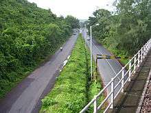
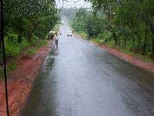
Currently, the road is comparatively narrow and without dividers for most part. Lack of dividers has led to increased incidence of head-on collisions between vehicles. At some places, signboards indicating left or right turns, speed-breakers, etc. are either damaged or missing. In addition to its narrow span, there are no guard railings along the sides of the highway. The sides of the road are at times at a lower level compared to the road.[8] Due to heavy human settlement around the highway and narrow span, the average speed on this highway is far lesser than compared to what can be attained on comparatively better highways such as NH3, NH4 or NH8. One can find carcasses of animals on the road, indicating the risk on inattentive animals coming in your way. Two-wheeler vehicles must take a special note of this. The road surface is uneven at certain stretches not just in rainy seasons, but even at other times.
At certain places in Karnataka, the surface is so badly damaged that the iron rods underneath are exposed. Presently, the work on widening this highway has been undertaken at certain stretches. Due to narrow span and lack of dividers, there are no separate lanes for oncoming traffic, driving and passing(over-taking). As a result, overtaking or passing is quite rampant. At times, motorists attempt over-taking even on curves where the oncoming traffic cannot be seen. Other motorists are advised to be on the look-out for such oncoming vehicles.
On 19 March 2013 a bus carrying over 50 persons fell off a bridge close to a river in Khed area of Ratnagiri district. 37 people lost their lives in the incident.
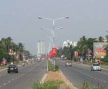
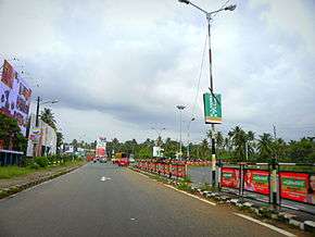
The highway in the state of Karnataka is being upgraded to 60-metre-wide grade separated highway, in which vehicles can travel at speed of 100 km per hour. It is a major overhaul, in which certain bridges are being constructed as 6-lane bridges for smooth movement of traffic. The widening work is going on in the complete stretch from the Goa border to the Kerala border. The stretch between Suratkal (NITK) to Kankanady cross (Mahavir Circle) has been already converted to four lane.[9] The four lane between Surathkal and Coondaapur is under progress.[10]
Connectivity
Prior to building of National Highway 66 (NH 66) then known as National Highway 17 ( NH17 ) in the 1960s and 1970s, ships and steamers running between Mumbai and Mangalore calling at different ports were only means of transport along the west coast of India adjoining the Arabian sea. These ship services was abandoned later. The NH 66 connects the interior parts of coastal regions with rest of the country. The NH 66 connects the major sea ports of West India, Mumbai, JNPT at Nhava Sheva, Mormugao (MPT), New Mangalore (NMPT), International Container Transshipment Terminal, Kochi & Ratnagiri Port and other important ports like beypore port, Kollam Port and Vizhinjam Port
Hence this National Highway 66 allows for movement of goods by trucks (lorries) from hinterland to major sea ports of India. The trade and commerce in the region has increased due to expansion of markets for agricultural and sea food produced in the region connected by this highway. The formation of NH 66 has led to development of tourism in the region connected by this highway. Goa state is classic example of this development. Many industries have been set up along National Highway 66 taking advantage of connectivity and proximity to sea ports on Arabian sea. The highway was the only source of connection between areas in the coastal districts, until the Konkan Railway was opened in 1998, between Mumbai and Mangalore.
Major cities and places on the highway
Maharashtra state
| Panvel | Mahad | Lote | Navdi | Rajapur |
| Pen | Poladpur | Chiplun | Nivli | Kharepatan |
| Vadkhal | Kashedi | Kamathe | Hathkhamba | Tarale |
| Gadab | Bharana Naka | Savarda | Pali | Nandgaon |
| Nagothana | Khed | Aravli (Kondivre) | Ratnagiri | Kankavli |
| Kolad | Asgani | Tural | Lanja | Kudal |
| Indapur | Asurde | Dhamani | Waked | Vengurla |
| Mangaon | Parshuram | Sangameshwar | Oni | Sawantwadi |
Goa state
| Pernem | Mapusa | Panjim |
| Margao | Cuncolim | Canacona |
Karnataka state
Uttara Kannada District
| Karwar | Ankola | Kumta |
| Honnavar | Murudeshwar | Bhatkal |
Dakshina Kannada (Udupi and Mangalore District)
| Baindur | Bijjur | Maravanthe | Kundapur |
| Saligrama | Brahmavar | Udupi | Kapu |
| Mulki | Suratkal | Mangalore | Ullal |
Kerala state
| Kasaragod | Kannur | Mahe |
| Kozhikode | Thrissur | Kochi |
| Alappuzha | Kollam | Thiruvananthapuram |
Lifestyle along NH 66
The NH 66 passes through hills, forests, rivers, rivulets, and streams, generally flowing westwards towards Arabian sea. Most of region has typical scene like coconut trees dotted all along with paddy fields and arecanut gardens. The road is uneven, bumps, curves, steep rises and narrow paths in between hillocks are found all over this highway. As this region experiences heavy rainfall, potholes are present occasionally.
Even though language spoken varies along the highway, food of the people along the NH 66 has some common ingredients like Coconut, Chilli, Pepper, Coconut oil, Fish etc. The region has higher literacy rate as compared to other regions of India. The building of National Highway 66 has led to rapid development of towns and cities along the highway.
Parallel Access Controlled Expressway
This highway is expected lose importance in Coastal Karnataka as Ministry of Road Transport & Highways, Government of India has proposed a Greenfield (i.e., new and parallel) access controlled Expressway Corridor connecting port cities of Mangalore-Karwar-Panaji.[4][11] This highway-expressway combination can be compared to the Mumbai-Pune Highway-Expressway combination. Two-wheeler, three-wheeler and local traffic will use the 4-lane highway (without access control and designed for slower traffic), where as truck, bus and four-wheeler will zoom at the maximum speed on the access-controlled 3D Right of Way designed 6/8-lane expressway. (3D right of way concept means adding the space (height) element to the usual length and breadth dimensions involved in road construction).
Popular Culture
A road trip along the highway was made popular by the Bollywood film Dil Chahta Hai.[12]
See also
References
- ↑ "Plan to widen National Highway 17 opposed". The Hindu. Chennai, India. 2010-03-19.
- ↑ Kamila, Raviprasad (2011-05-24). "20-km road widening completed between Kundapur and Surathkal". The Hindu. Chennai, India.
- ↑ "All new national highways to be made of concrete: Nitin Gadkari". timesofindia-economictimes.
- 1 2 "Five new expressways to come up in State". Deccan Herald.
- ↑ http://www.indianurbaninfrastructure.com/?p=17349
- ↑ "Widening of state's killer highway awaits Centre's nod since 2009 - The Times of India". The Times Of India.
- ↑ "Mumbai-Goa National Highway may get a tunnel". dna. 8 April 2011.
- ↑ "Travelers forsake risky Goa road". www.timesofindia.indiatimes.com. Retrieved 2012-08-03.
- ↑ "BC Road- Suratkal four laning to be completed by June". www.mangalorean.com. Retrieved 2012-08-03.
- ↑ "Restrict four lane widening to 45 metres". www.deccanherald.com. Retrieved 2012-08-03.
- ↑ "New approach mooted for infrastructure projects". The Hindu. Chennai, India. 2012-02-03.
- ↑ "Mumbai To Goa Road Trip By Car | Distance, Directions & More". Holidify. 2015-10-16. Retrieved 2016-06-11.
External links
| Wikimedia Commons has media related to NH 66 (India). |
