NS Line (Portland Streetcar)
| North/South Line | ||||||||||||||||||||||||||||||||||||||||||||||||||||||||||||||||||||||||||||||||||||||||||||||||||||||||||||||||||||||||||||||||||||||||||||||||||||||||||||||||||||||||||||||||||||||||||||||||||||||||||||||||||||||||||||||||||||||||||||||||||||||||||||||||||||||||||||||||||||||||||||||||||||||||||||||||||||||||||||||||||||||||||||||||||||||||||||||||||||||||||||||||
|---|---|---|---|---|---|---|---|---|---|---|---|---|---|---|---|---|---|---|---|---|---|---|---|---|---|---|---|---|---|---|---|---|---|---|---|---|---|---|---|---|---|---|---|---|---|---|---|---|---|---|---|---|---|---|---|---|---|---|---|---|---|---|---|---|---|---|---|---|---|---|---|---|---|---|---|---|---|---|---|---|---|---|---|---|---|---|---|---|---|---|---|---|---|---|---|---|---|---|---|---|---|---|---|---|---|---|---|---|---|---|---|---|---|---|---|---|---|---|---|---|---|---|---|---|---|---|---|---|---|---|---|---|---|---|---|---|---|---|---|---|---|---|---|---|---|---|---|---|---|---|---|---|---|---|---|---|---|---|---|---|---|---|---|---|---|---|---|---|---|---|---|---|---|---|---|---|---|---|---|---|---|---|---|---|---|---|---|---|---|---|---|---|---|---|---|---|---|---|---|---|---|---|---|---|---|---|---|---|---|---|---|---|---|---|---|---|---|---|---|---|---|---|---|---|---|---|---|---|---|---|---|---|---|---|---|---|---|---|---|---|---|---|---|---|---|---|---|---|---|---|---|---|---|---|---|---|---|---|---|---|---|---|---|---|---|---|---|---|---|---|---|---|---|---|---|---|---|---|---|---|---|---|---|---|---|---|---|---|---|---|---|---|---|---|---|---|---|---|---|---|---|---|---|---|---|---|---|---|---|---|---|---|---|---|---|---|---|---|---|---|---|---|---|---|---|---|---|---|---|---|---|---|---|---|---|---|---|---|---|---|---|---|---|---|---|---|---|---|---|---|---|---|---|---|---|---|---|---|---|---|---|---|---|---|---|---|---|---|
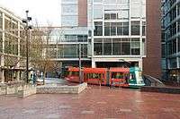
.jpg) A NW 23rd-bound streetcar in the South Park Blocks | ||||||||||||||||||||||||||||||||||||||||||||||||||||||||||||||||||||||||||||||||||||||||||||||||||||||||||||||||||||||||||||||||||||||||||||||||||||||||||||||||||||||||||||||||||||||||||||||||||||||||||||||||||||||||||||||||||||||||||||||||||||||||||||||||||||||||||||||||||||||||||||||||||||||||||||||||||||||||||||||||||||||||||||||||||||||||||||||||||||||||||||||||
| Overview | ||||||||||||||||||||||||||||||||||||||||||||||||||||||||||||||||||||||||||||||||||||||||||||||||||||||||||||||||||||||||||||||||||||||||||||||||||||||||||||||||||||||||||||||||||||||||||||||||||||||||||||||||||||||||||||||||||||||||||||||||||||||||||||||||||||||||||||||||||||||||||||||||||||||||||||||||||||||||||||||||||||||||||||||||||||||||||||||||||||||||||||||||
| Other name(s) | NS Line | |||||||||||||||||||||||||||||||||||||||||||||||||||||||||||||||||||||||||||||||||||||||||||||||||||||||||||||||||||||||||||||||||||||||||||||||||||||||||||||||||||||||||||||||||||||||||||||||||||||||||||||||||||||||||||||||||||||||||||||||||||||||||||||||||||||||||||||||||||||||||||||||||||||||||||||||||||||||||||||||||||||||||||||||||||||||||||||||||||||||||||||||
| Type | Streetcar | |||||||||||||||||||||||||||||||||||||||||||||||||||||||||||||||||||||||||||||||||||||||||||||||||||||||||||||||||||||||||||||||||||||||||||||||||||||||||||||||||||||||||||||||||||||||||||||||||||||||||||||||||||||||||||||||||||||||||||||||||||||||||||||||||||||||||||||||||||||||||||||||||||||||||||||||||||||||||||||||||||||||||||||||||||||||||||||||||||||||||||||||
| System | Portland Streetcar | |||||||||||||||||||||||||||||||||||||||||||||||||||||||||||||||||||||||||||||||||||||||||||||||||||||||||||||||||||||||||||||||||||||||||||||||||||||||||||||||||||||||||||||||||||||||||||||||||||||||||||||||||||||||||||||||||||||||||||||||||||||||||||||||||||||||||||||||||||||||||||||||||||||||||||||||||||||||||||||||||||||||||||||||||||||||||||||||||||||||||||||||
| Status | Operational | |||||||||||||||||||||||||||||||||||||||||||||||||||||||||||||||||||||||||||||||||||||||||||||||||||||||||||||||||||||||||||||||||||||||||||||||||||||||||||||||||||||||||||||||||||||||||||||||||||||||||||||||||||||||||||||||||||||||||||||||||||||||||||||||||||||||||||||||||||||||||||||||||||||||||||||||||||||||||||||||||||||||||||||||||||||||||||||||||||||||||||||||
| Locale | Portland, Oregon | |||||||||||||||||||||||||||||||||||||||||||||||||||||||||||||||||||||||||||||||||||||||||||||||||||||||||||||||||||||||||||||||||||||||||||||||||||||||||||||||||||||||||||||||||||||||||||||||||||||||||||||||||||||||||||||||||||||||||||||||||||||||||||||||||||||||||||||||||||||||||||||||||||||||||||||||||||||||||||||||||||||||||||||||||||||||||||||||||||||||||||||||
| Termini |
NW 23rd Avenue & NW Marshall Street SW Lowell Street & SW Bond Avenue | |||||||||||||||||||||||||||||||||||||||||||||||||||||||||||||||||||||||||||||||||||||||||||||||||||||||||||||||||||||||||||||||||||||||||||||||||||||||||||||||||||||||||||||||||||||||||||||||||||||||||||||||||||||||||||||||||||||||||||||||||||||||||||||||||||||||||||||||||||||||||||||||||||||||||||||||||||||||||||||||||||||||||||||||||||||||||||||||||||||||||||||||
| Stations | 46 | |||||||||||||||||||||||||||||||||||||||||||||||||||||||||||||||||||||||||||||||||||||||||||||||||||||||||||||||||||||||||||||||||||||||||||||||||||||||||||||||||||||||||||||||||||||||||||||||||||||||||||||||||||||||||||||||||||||||||||||||||||||||||||||||||||||||||||||||||||||||||||||||||||||||||||||||||||||||||||||||||||||||||||||||||||||||||||||||||||||||||||||||
| Website |
Portland Streetcar Inc. TriMet | |||||||||||||||||||||||||||||||||||||||||||||||||||||||||||||||||||||||||||||||||||||||||||||||||||||||||||||||||||||||||||||||||||||||||||||||||||||||||||||||||||||||||||||||||||||||||||||||||||||||||||||||||||||||||||||||||||||||||||||||||||||||||||||||||||||||||||||||||||||||||||||||||||||||||||||||||||||||||||||||||||||||||||||||||||||||||||||||||||||||||||||||
| Operation | ||||||||||||||||||||||||||||||||||||||||||||||||||||||||||||||||||||||||||||||||||||||||||||||||||||||||||||||||||||||||||||||||||||||||||||||||||||||||||||||||||||||||||||||||||||||||||||||||||||||||||||||||||||||||||||||||||||||||||||||||||||||||||||||||||||||||||||||||||||||||||||||||||||||||||||||||||||||||||||||||||||||||||||||||||||||||||||||||||||||||||||||||
| Opened | July 20, 2001 | |||||||||||||||||||||||||||||||||||||||||||||||||||||||||||||||||||||||||||||||||||||||||||||||||||||||||||||||||||||||||||||||||||||||||||||||||||||||||||||||||||||||||||||||||||||||||||||||||||||||||||||||||||||||||||||||||||||||||||||||||||||||||||||||||||||||||||||||||||||||||||||||||||||||||||||||||||||||||||||||||||||||||||||||||||||||||||||||||||||||||||||||
| Owner | City of Portland | |||||||||||||||||||||||||||||||||||||||||||||||||||||||||||||||||||||||||||||||||||||||||||||||||||||||||||||||||||||||||||||||||||||||||||||||||||||||||||||||||||||||||||||||||||||||||||||||||||||||||||||||||||||||||||||||||||||||||||||||||||||||||||||||||||||||||||||||||||||||||||||||||||||||||||||||||||||||||||||||||||||||||||||||||||||||||||||||||||||||||||||||
| Operator(s) |
Portland Streetcar, Inc. TriMet | |||||||||||||||||||||||||||||||||||||||||||||||||||||||||||||||||||||||||||||||||||||||||||||||||||||||||||||||||||||||||||||||||||||||||||||||||||||||||||||||||||||||||||||||||||||||||||||||||||||||||||||||||||||||||||||||||||||||||||||||||||||||||||||||||||||||||||||||||||||||||||||||||||||||||||||||||||||||||||||||||||||||||||||||||||||||||||||||||||||||||||||||
| Character | At-grade, in mixed traffic and exclusive lanes | |||||||||||||||||||||||||||||||||||||||||||||||||||||||||||||||||||||||||||||||||||||||||||||||||||||||||||||||||||||||||||||||||||||||||||||||||||||||||||||||||||||||||||||||||||||||||||||||||||||||||||||||||||||||||||||||||||||||||||||||||||||||||||||||||||||||||||||||||||||||||||||||||||||||||||||||||||||||||||||||||||||||||||||||||||||||||||||||||||||||||||||||
| Technical | ||||||||||||||||||||||||||||||||||||||||||||||||||||||||||||||||||||||||||||||||||||||||||||||||||||||||||||||||||||||||||||||||||||||||||||||||||||||||||||||||||||||||||||||||||||||||||||||||||||||||||||||||||||||||||||||||||||||||||||||||||||||||||||||||||||||||||||||||||||||||||||||||||||||||||||||||||||||||||||||||||||||||||||||||||||||||||||||||||||||||||||||||
| Line length | 3.9 miles (6.3 km) | |||||||||||||||||||||||||||||||||||||||||||||||||||||||||||||||||||||||||||||||||||||||||||||||||||||||||||||||||||||||||||||||||||||||||||||||||||||||||||||||||||||||||||||||||||||||||||||||||||||||||||||||||||||||||||||||||||||||||||||||||||||||||||||||||||||||||||||||||||||||||||||||||||||||||||||||||||||||||||||||||||||||||||||||||||||||||||||||||||||||||||||||
| Track gauge | 4 ft 8 1⁄2 in (1,435 mm) | |||||||||||||||||||||||||||||||||||||||||||||||||||||||||||||||||||||||||||||||||||||||||||||||||||||||||||||||||||||||||||||||||||||||||||||||||||||||||||||||||||||||||||||||||||||||||||||||||||||||||||||||||||||||||||||||||||||||||||||||||||||||||||||||||||||||||||||||||||||||||||||||||||||||||||||||||||||||||||||||||||||||||||||||||||||||||||||||||||||||||||||||
| Minimum radius | 18 m (59 ft)[1] | |||||||||||||||||||||||||||||||||||||||||||||||||||||||||||||||||||||||||||||||||||||||||||||||||||||||||||||||||||||||||||||||||||||||||||||||||||||||||||||||||||||||||||||||||||||||||||||||||||||||||||||||||||||||||||||||||||||||||||||||||||||||||||||||||||||||||||||||||||||||||||||||||||||||||||||||||||||||||||||||||||||||||||||||||||||||||||||||||||||||||||||||
| Electrification | Overhead, 750 V DC | |||||||||||||||||||||||||||||||||||||||||||||||||||||||||||||||||||||||||||||||||||||||||||||||||||||||||||||||||||||||||||||||||||||||||||||||||||||||||||||||||||||||||||||||||||||||||||||||||||||||||||||||||||||||||||||||||||||||||||||||||||||||||||||||||||||||||||||||||||||||||||||||||||||||||||||||||||||||||||||||||||||||||||||||||||||||||||||||||||||||||||||||
| Maximum incline | 8.75% | |||||||||||||||||||||||||||||||||||||||||||||||||||||||||||||||||||||||||||||||||||||||||||||||||||||||||||||||||||||||||||||||||||||||||||||||||||||||||||||||||||||||||||||||||||||||||||||||||||||||||||||||||||||||||||||||||||||||||||||||||||||||||||||||||||||||||||||||||||||||||||||||||||||||||||||||||||||||||||||||||||||||||||||||||||||||||||||||||||||||||||||||
| ||||||||||||||||||||||||||||||||||||||||||||||||||||||||||||||||||||||||||||||||||||||||||||||||||||||||||||||||||||||||||||||||||||||||||||||||||||||||||||||||||||||||||||||||||||||||||||||||||||||||||||||||||||||||||||||||||||||||||||||||||||||||||||||||||||||||||||||||||||||||||||||||||||||||||||||||||||||||||||||||||||||||||||||||||||||||||||||||||||||||||||||||
The North/South Line (NS Line) is one of two routes forming the Portland Streetcar system in Portland, Oregon, United States. The 3.9-mile (6.3 km) route, operated by Portland Streetcar Inc. (PSI) and TriMet, connects the Nob Hill District to the South Waterfront. Opened over its first 2.4-mile (3.9 km) section in 2001, it was the initial line of the Portland Streetcar system and was the first new streetcar line in the United States since World War II to use modern vehicles.[2] It was given the name North/South Line (abbreviated as NS Line) in September 2012, with the opening of the system's second line (the Central Loop, or CL Line), having previously had no distinct route name.[3][4]
History
The first section of the North/South line utilized a fleet of five vehicles[5] on a 2.4-mile (3.9 km)[2] route commencing at Portland State University, running north through the Pearl District and then west to NW 23rd Avenue, in the Nob Hill neighborhood, to the Legacy Good Samaritan Medical Center, and then returning to Portland State University via parallel streets. Although its one-way length was 2.4 miles, PSI commonly described it as a "5-mile loop", because it followed separate streets – one or two blocks apart – over its entire length.[2]
This first phase of the North/South line cost $57 million to build, most of which was received from local sources. Only $5 million came from the federal government for the construction.[6] It opened on July 20, 2001.[5][2]
In January 2004, construction began to extend the line south of Portland State University to RiverPlace. The extension cost $16 million[6] and opened for service on March 11, 2005.[5][7] This 0.6-mile (1 km) section includes a short length of two-way single-track operation, about 100 yards (91 m) in length, along Montgomery Street and 4th Avenue, which includes signals for the streetcars to ensure that only one direction is in use at any given time. It also includes the steepest grade on the system, 8.75% in the block of Harrison Street between 1st and 2nd Avenues.[8]
Another extension, of 0.42 mi (0.68 km) south to the lower terminus of the Portland Aerial Tram at SW Gibbs Street, in the South Waterfront District, opened on temporary tracks on October 20, 2006, all on its own right-of-way formerly used by the Willamette Shore Trolley and initially also single-track. In November 2011, the streetcar line began using new double track on a realigned section of Moody Avenue.[5]
On August 17, 2007, an extension of the line south of Gibbs Street to SW Lowell and Bond opened to better serve the South Waterfront district.[5] This 0.46-mile (0.74 km) extension is a 10-block loop, from SW Moody and Gibbs proceeding south on Moody Avenue, east on Lowell Street and north on Bond Avenue to OHSU Commons at Gibbs, which stop is also directly adjacent to the entrance to the Portland Aerial Tram, linking the stop to Oregon Health & Science University (OHSU) atop Marquam Hill. This final extension of the line cost $14.45 million.[6] The extensions that opened in 2005, 2006 and 2007 increased the one-way length of the line to its current 3.9 miles (6.3 km).
The stops at OHSU Commons and Gibbs Street received a connection to the Lair Hill neighborhood that was otherwise cut off by Interstate 5 upon the opening of the Gibbs Street Pedestrian Bridge in July 2012.
Until 2012, the north-south streetcar line had no route name, being referred to only as the Portland Streetcar line, because it was the only line in the PS system. However, with the opening of the system's second line, in September 2012, the original line was designated as the North/South Line (abbreviated as NS Line) to distinguish it from the new Central Loop line (or CL Line).[3][4]
In 2015, the NS Line's SW Moody & Meade station will be across the street from the end of the Tilikum Crossing bridge, which will connect the North/South line with the Central Loop line, MAX Orange Line, and additional TriMet bus services.
In March 2016, five stops were closed. The stops were closed in an effort to speed up travel times.[9]
Vintage Trolley service
From 2001 until 2005, Portland Vintage Trolley service also operated on what is now known as the NS Line, on most weekends. Of four replica 1904 Brill streetcars owned by TriMet and in use on the MAX Light Rail system since 1991, two were transferred to the city of Portland in 2001 for use on the Portland Streetcar line. The service operated on Saturdays and Sundays, using one car at a time, from about 10 a.m. to 6 p.m.[2] They were non-wheelchair-accessible. Vintage Trolley service on Portland Streetcar was temporarily suspended around the end of November 2005,[10] in part because of maintenance problems with the two cars, and in part because the opening of the extension from PSU to RiverPlace in March 2005 caused operations difficulties with the Vintage Trolley cars. The VT service, which resumed in May 2005 after a five-month suspension for repair work on the two cars, had continued to end at PSU, not serving the then-new section to RiverPlace.[11] The late 2005 suspension eventually became permanent, and the two VT cars were transferred back to TriMet.
References
- ↑ Trackway Infrastructure Guidelines for Light Rail Circulator Systems (April 2007); retrieved 2012-09-10 from APTA's Streetcar Subcommittee website
- 1 2 3 4 5 Taplin, M. R. (October 2001). "Return of the (modern) streetcar: Portland leads the way". Tramways & Urban Transit. Hersham, Surrey, UK: Ian Allan Publishing Ltd. ISSN 1460-8324. Retrieved July 7, 2013.
- 1 2 "Portland Streetcar Introduces 'Central Loop' Service". Passenger Transport. American Public Transportation Association. October 5, 2012. Retrieved January 26, 2014.
- 1 2 Tramways & Urban Transit, July 2012, p. 276. UK: LRTA Publishing.
- 1 2 3 4 5 "Streetcar History". Portland Streetcar Inc. Retrieved January 23, 2014.
- 1 2 3 "Portland Streetcar Capital and Operations Funding" (PDF). Portland Streetcar Inc. September 8, 2010. Retrieved January 23, 2014.
- ↑ Green, Susan (March 10, 2005). "Streetcar marks opening of extension on Friday". The Oregonian. p. D2.
- ↑ Tramways & Urban Transit, August 2013, p. 352. UK: LRTA Publishing.
- ↑ Njus, Elliot (March 30, 2016). "Portland Streetcar makes stop closures permanent". The Oregonian.
- ↑ Tramways & Urban Transit, March 2007, p. 108. Ian Allan Publishing/Light Rail Transit Association.
- ↑ Tramways & Urban Transit, September 2005, p. 368. Ian Allan Publishing/Light Rail Transit Association.
External links
- Route map on official site, with links to schedule pages
- NS Line schedule (September 2015) as PDF on official site