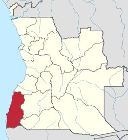
Namibe Province
| Namibe | |
|---|---|
| Province | |
|
Olive trees in Namibe Province | |
 Namibe, province of Angola | |
| Country | Angola |
| Capital | Namibe |
| Area | |
| • Total | 57,091 km2 (22,043 sq mi) |
| Population (2014 census) | |
| • Total | 471,613 |
| • Density | 8.3/km2 (21/sq mi) |
| ISO 3166 code | AO-NAM |
| Website |
www |
Namibe is a province of Angola, previously known as Moçâmedes when under Portuguese rule. It has an area of 57,091 km² and had a 2014 census population of 471,613.[1] The port and city of Namibe is the capital of the province with a population of 132,900 in 2004. Iona National Park lies within the province.
History
Under Portuguese colonial administration the Portuguese name for the area was Moçâmedes (also spelled Mossâmedes).[2] The current name of the province is derived from the Namib Desert, lying predominantly in Namibia; the northernmost part, however, extended into the province of Namibe. Extensive flooding in the province occurred on April 5, 2001, with the Bero and Giraul River severely affecting roads and people in Namibe, Huila and Benguela provinces.[3] A reported 20 people in Namibe Province lost their lives during the flood.[4]
Geography and wildlife
Namibe Province covers an area of 57,091 km², much of which is desert. The capital of the province is the city of Namibe, with the second city being Tômbua or Tómbwa (formerly Porto Alexandre). In the Namib Desert can be seen the rare Welwitschia mirabilis, "a strange plant with a giant root", and also the Iona National Park.[5] Lake Arco, a fresh-water oasis, is a stunning sight in the middle of the desert. Near the coast of the Bentiaba desert and in Iona National Park, Late Cretaceous fossils of sharks, turtles, mosasaurs, plesiosaurs and sauropods have been discovered.[6]
Municipalities
The province is divided into five municipalities, Bibala, Camacuio, Namibe, Tômbua and Virei,[1] which in turn are divided into 21 communes.
Demographics
Namibe Province had an official estimated population of 313,667 in 2006,[1] and as of 2014 2014 there are an estimated 376,124 inhabitants. The desert is sparsely inhabited, but is inhabited by Herero groups (vaKuval, Ova-Himba) and small Khoisan groups (Kwisi, Kwepe).[2]
Economy
Agriculture is the main source of income in Namibe Province, the principal crops being citrus fruits, olives, guava, millet and livestock, including the rearing of sheep and goats. Fishing is another means of livelihood for the people of Namibe Province, Tômbua being the main market. The province has significant reserves of gold, copper,[7] manganese, chromium, tin, lignite and marble. The Yuri Gagarin Airport and the Commercial Port of Namibe, are the two main centres for transport for the import and export of products.
References
- 1 2 3 "Angola". Geohive. Retrieved 22 September 2014.
- 1 2 Silva, Elisete Marques da (1 May 2003). Impactos da ocupação colonial nas sociedades rurais do sul de Angola (in Portuguese). Centro de Estudos Internacionais do Instituto Universitário de Lisboa (ISCTE-IUL). p. 5. ISBN 978-972-8335-08-3.
- ↑ Popular Mechanics. Hearst Magazines. July 2001. p. 22. ISSN 0032-4558.
- ↑ "IRI Climate Digest May 2001". Iri.columbia.edu. Retrieved 22 September 2014.
- ↑ Nature's last strongholds: an encyclopedia of habitats and conservation. Time-Life Books. 1991. p. 195.
- ↑ James, W. Martin (5 May 2011). Historical Dictionary of Angola. Scarecrow Press. p. 181. ISBN 978-0-8108-7458-9.
- ↑ Africa South of the Sahara 2004. Europa Publications, Psychology Press. 2003. p. 52. ISBN 978-1-85743-183-4.
External links
| Wikimedia Commons has media related to Namibe Province. |
- Official website of province governor
- Information on this province at the Angolan ministry for territorial administration
- Information on this province at Info Angola
- Province geographical info at geoview.info
Coordinates: 15°11′43″S 12°09′03″E / 15.19528°S 12.15083°E