Nathan Road
|
Nathan Road 彌敦道 | |||||||||||||||
|
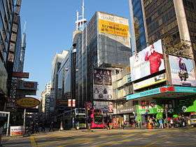
Jordan section of Nathan Road, at its intersection with Austin Road | |||||||||||||||
| Traditional Chinese | 彌敦道 | ||||||||||||||
|---|---|---|---|---|---|---|---|---|---|---|---|---|---|---|---|
| Simplified Chinese | 弥敦道 | ||||||||||||||
| |||||||||||||||
Nathan Road is the main thoroughfare in Kowloon, Hong Kong that goes in a south-north direction from Tsim Sha Tsui to Sham Shui Po. It is lined with shops and restaurants and throngs with tourists, and was known in the post-World War II years as the Golden Mile, a name that is now rarely used. It starts on the southern part of Kowloon at its junction with Salisbury Road, a few metres north of Victoria Harbour, and ends at its intersection with Boundary Street in the north. Portions of the Kwun Tong and Tsuen Wan Lines (Prince Edward, Mong Kok, Yau Ma Tei, Jordan and Tsim Sha Tsui) run underneath Nathan Road.The total length of the Nathan Road is about 3.6 kilometres (2.2 mi).
History

The first section of the road was completed in 1861. It was the very first road built in Kowloon, after the land was ceded by the Qing Dynasty government to the United Kingdom and made part of the crown colony in 1860. The road was originally named Robinson Road, after Sir Hercules Robinson, the 5th Governor of Hong Kong. To avoid confusion with the Robinson Road on Hong Kong Island, the name was changed to Nathan Road in 1909,[1] after Sir Matthew Nathan, the 13th Governor who served between 1904 and 1907.
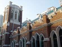
The early Nathan Road was largely residential, with colonial-style houses with arched verandahs and covered archways. It was home to the Whitfield Barracks, which later became Kowloon Park. Saint Andrew's Church, the oldest Anglican church in Kowloon, has been located there since its completion in 1906.
The section of the road from Gascoigne Road to Argyle Street was originally named Coronation Road (加冕道), in honour of the coronation of King George V in 1911. The road was renamed as part of Nathan Road in 1926, after works joining the road and Nathan Road was completed. The section of Tai Po Road south of Boundary Street was also renamed as part of the road.
In 1996, the Garley Building fire broke out, killing 41 people.[2] In 2008, the Cornwall Court fire broke out, involving more than 200 firefighters, killing 4 people, including 2 fire fighters.[3]
Significant buildings and landmarks along the road

- The Peninsula Hotel (corner of Salisbury Road and Nathan Road)
- Chungking Mansions (#36-44)
- iSQUARE (#63)
- Kowloon Park
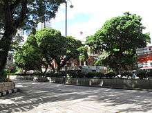
- Park Lane Shopper's Boulevard
- The ONE, at the location of the former Tung Ying Building (#100)
- Kowloon Masjid and Islamic Centre (#105)
- The Mira Hong Kong (#118)
- Miramar Shopping Centre (#132-134)
- Former Kowloon British School (#136). Now houses the Antiquities and Monuments Office
- St. Andrew's Church (Kowloon) (#138)
- Yau Tsim District Police Headquarters and Tsim Sha Tsui Police Station[4] (#213)
- Garley Building (#233-239, destroyed by fire in 1996[2])
- Manulife Provident Funds Place (also known as Wing On Kowloon Center, #345)
- Novotel Nathan Road Kowloon Hong Kong (#348)
- Eaton Hotel Hong Kong (#380)
- Kowloon Central Post Office (#405)
- Sino Centre (#582-592)
- HSBC Building Mongkok (#673)[5]
- Cornwall Court (#687-689). Site of the 2008 Cornwall Court fire.[3]
Public transport
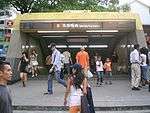
Five stations of the Mass Transit Railway (MTR) are built directly underneath Nathan Road. These stations are, from north to south:
- Prince Edward Station in Mong Kok, at the intersection between Nathan Road and Prince Edward Road West
- Mong Kok Station (or Argyle Station) in Mong Kok, at the intersection between Nathan Road and Argyle Street
- Yau Ma Tei Station (or Waterloo Station) in Yau Ma Tei, at the intersection between Nathan Road and Waterloo Road
- Jordan Station in Jordan, at the intersection between Nathan Road and Jordan Road
- Tsim Sha Tsui Station in Tsim Sha Tsui, at the intersection between Nathan Road and Carnarvon Road
The road is heavily trafficked by numerous bus routes.
Gallery
- Nathan Road, Hong Kong
.jpg) The end section of Nathan Road
The end section of Nathan Road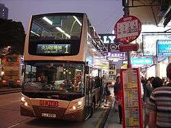
 Exit A1 of Tsim Sha Tsui Station on Nathan Road.
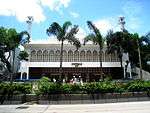
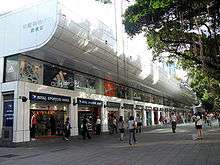 Park Lane Shopper's Boulevard.
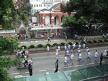 2008 Summer Olympics torch relay in front of the Former Kowloon British School.
 Nathan Road, near Mong Kok.
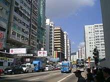 Nathan Road, in the Prince Edward area.
 Nathan Road, Jordan section.
See also
- Yau Tsim Mong District
- List of streets and roads in Hong Kong
- List of leading shopping streets and districts by city
References
- ↑ The Hong Kong Government Gazette, March 19, 1909
- 1 2 RTHK. "RTHK gbcode." Cornwall Court Fire Tragedy; Bill Gates in Hong Kong; Shopaholics . Retrieved on 2008-09-28.
- 1 2 Yahoo. "Yahoo.com." Four dead as HK nightclub fire spreads. Retrieved on 2008-08-28.
- ↑ "Hong Kong Police Force: Address of Tsim Sha Tsui Division". Retrieved 17 July 2014.
- ↑ "HSBC Business Centres: Address for Mongkok Branch".
External links
| Wikimedia Commons has media related to Nathan Road, Hong Kong. |
From south to north | ||||||||
| Tsim Sha Tsui |
|  | ||||||
| Jordan |
| |||||||
| Yau Ma Tei |
| |||||||
| Mong Kok |
| |||||||
| Prince Edward |
| |||||||
| MTR stations | ||||||||
| Kowloon City |
|
|---|---|
| Kwun Tong | |
| Sham Shui Po |
|
| Wong Tai Sin | |
| Yau Tsim Mong | |
| |
Coordinates: 22°18′36″N 114°10′16″E / 22.309889°N 114.171133°E