| [2] |
Name on the Register |
Image |
Date listed[3] |
Location |
City or town |
Description |
|---|
| 1 |
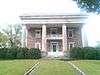
Ashland Farm |
Upload image |
000000001973-10-18-0000October 18, 1973
(#73000646) |
SW of Rossville off GA 193
34°57′16″N 85°20′46″W / 34.954444°N 85.346111°W / 34.954444; -85.346111 (Ashland Farm) |
Rossville |
|
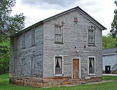
| 2 |
Cavender's Store |
Upload image |
000000001992-03-20-0000March 20, 1992
(#92000143) |
Jct. of GA 201 and GA 136, SW corner
34°40′25″N 85°06′54″W / 34.673611°N 85.115°W / 34.673611; -85.115 (Cavender's Store) |
Villanow |
|
| 3 |
Chattooga Academy |
Upload image |
000000001980-02-15-0000February 15, 1980
(#80001253) |
306 N. Main St.
34°42′31″N 85°16′51″W / 34.708611°N 85.280833°W / 34.708611; -85.280833 (Chattooga Academy) |
LaFayette |
|
| 4 |
Chickamauga and Chattanooga National Military Park |
|
000000001966-10-15-0000October 15, 1966
(#66000274) |
S of Chattanooga on U.S. 27
34°58′09″N 85°17′07″W / 34.9692°N 85.2853°W / 34.9692; -85.2853 (Chickamauga and Chattanooga National Military Park) |
Wildwood |
administered by the National Park Service
|
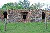
| 5 |
Chickamauga Coal and Iron Company Coke Ovens |
|
000000002009-04-09-0000April 9, 2009
(#09000188) |
Georgia State Route 341
34°52′53″N 85°17′43″W / 34.8814°N 85.2953°W / 34.8814; -85.2953 (Chickamauga Coal and Iron Company Coke Ovens) |
Chickamauga |
|
| 6 |
Chickamauga Historic District |
|
000000002007-07-20-0000July 20, 2007
(#07000700) |
Roughly centered on Cove Rd. and bounded by Crescent, Pearl, & 6th Sts. and the Central of Georgia RR
Coordinates missing |
Chickamauga |
|
| 7 |
Chickamauga Lodge No. 221, Free and Accepted Masons, Prince Hall Affiliate |
|
000000002006-08-30-0000August 30, 2006
(#06000736) |
1378 GA 341 S
34°51′24″N 85°18′19″W / 34.8567°N 85.3053°W / 34.8567; -85.3053 (Chickamauga Lodge No. 221, Free and Accepted Masons, Prince Hall Affiliate) |
Chickamauga |
|
| 8 |
Gordon-Lee House |
|
000000001976-03-22-0000March 22, 1976
(#76000654) |
217 Cove Rd.
Coordinates missing |
Chickamauga |
|
| 9 |
Lane House |
Upload image |
000000001976-12-12-0000December 12, 1976
(#76000655) |
Weathers Dr., east of Kensington[4]
34°46′43″N 85°20′24″W / 34.7786°N 85.34°W / 34.7786; -85.34 (Lane House) |
Kensington |
|
| 10 |
Lee and Gordon Mill |
|
000000001980-02-08-0000February 8, 1980
(#80001252) |
Red Belt Rd.
34°53′01″N 85°16′01″W / 34.8836°N 85.2669°W / 34.8836; -85.2669 (Lee and Gordon Mill) |
Chickamauga |
|
| 11 |
Lookout Mountain Fairyland Club |
Upload image |
000000001990-06-21-0000June 21, 1990
(#90000991) |
1201 Fleetwood Dr.
34°58′31″N 85°20′55″W / 34.9753°N 85.3486°W / 34.9753; -85.3486 (Lookout Mountain Fairyland Club) |
Lookout Mountain |
|
| 12 |
Marsh-Warthen House |
|
000000002005-01-12-0000January 12, 2005
(#04001467) |
N. Main St.
34°42′33″N 85°16′52″W / 34.7092°N 85.2811°W / 34.7092; -85.2811 (Marsh-Warthen House) |
LaFayette |
|
| 13 |
McLemore Cove Historic District |
Upload image |
000000001994-09-23-0000September 23, 1994
(#94001140) |
3 mi. S of Chickamauga, in an area roughly bounded by Lookout and Pigeon Mtns., and GA 136
34°44′22″N 85°23′13″W / 34.739444°N 85.386944°W / 34.739444; -85.386944 (McLemore Cove Historic District) |
Kensington |
|
| 14 |
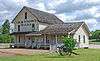
Miller Brothers Farm |
Upload image |
000000001987-08-06-0000August 6, 1987
(#87001332) |
GA 912
34°46′23″N 85°22′32″W / 34.773056°N 85.375556°W / 34.773056; -85.375556 (Miller Brothers Farm) |
Kensington |
|
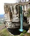
| 15 |
Rock City Gardens |
|
000000002014-09-17-0000September 17, 2014
(#14000619) |
1400 Patton Rd.
34°58′26″N 85°20′55″W / 34.973889°N 85.348611°W / 34.973889; -85.348611 (Rock City Gardens) |
Lookout Mountain |
|
| 16 |
John Ross House |
|
000000001973-11-07-0000November 7, 1973
(#73000647) |
Lake Ave. and Spring St.
34°58′52″N 85°17′05″W / 34.98110°N 85.28478°W / 34.98110; -85.28478 (John Ross House) |
Rossville |
|
| 17 |
US Post Office-Rossville Main |
|
000000001986-08-06-0000August 6, 1986
(#86002272) |
301 Chickamauga Ave.
34°58′59″N 85°17′11″W / 34.983056°N 85.286389°W / 34.983056; -85.286389 (US Post Office-Rossville Main) |
Rossville |
|
| 18 |
Walker County Courthouse |
Upload image |
000000001980-09-18-0000September 18, 1980
(#80001254) |
Duke St.
34°42′15″N 85°16′50″W / 34.704167°N 85.280556°W / 34.704167; -85.280556 (Walker County Courthouse) |
LaFayette |
|

.jpg)