LaFayette, Georgia
| LaFayette, Georgia | |
|---|---|
| City | |
|
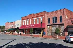
Stores in downtown LaFayette | |
 Location in Walker County and the state of Georgia | |
| Coordinates: 34°42′35″N 85°17′2″W / 34.70972°N 85.28389°WCoordinates: 34°42′35″N 85°17′2″W / 34.70972°N 85.28389°W | |
| Country | United States |
| State | Georgia |
| County | Walker |
| Area | |
| • Total | 8.1 sq mi (21 km2) |
| • Land | 8.1 sq mi (21 km2) |
| • Water | 0 sq mi (0 km2) |
| Elevation | 810 ft (247 m) |
| Population (2010) | |
| • Total | 7,121 |
| • Density | 827.4/sq mi (319.1/km2) |
| Time zone | Eastern (EST) (UTC-5) |
| • Summer (DST) | EDT (UTC-4) |
| ZIP code | 30728 |
| Area code(s) | 706/762 |
| FIPS code | 13-44312[1] |
| GNIS feature ID | 0316521[2] |
| Website | City of Lafayette |
LaFayette is a city in and the county seat of Walker County, Georgia, United States. As of the 2000 census, the city population was 6,702 and 7,121 at the 2010 census. It was known originally as Chattooga.
LaFayette is part of the Chattanooga, TN-GA Metropolitan Statistical Area.
History
LaFayette was originally founded as Chattooga, in 1835, as the seat of newly formed Walker County.[3] The county was named after the former United States senator Freeman Walker.[4] Chattooga was renamed LaFayette in 1836 after Gilbert du Motier, Marquis de Lafayette, the French aristocrat who fought in the American Revolutionary War.[5]
Geography
LaFayette is located at 34°42′35″N 85°17′2″W / 34.70972°N 85.28389°W (34.709704, -85.283862).[6] According to the United States Census Bureau, the city has a total area of 8.1 square miles (21 km2), all of it land.
Demographics
| Historical population | |||
|---|---|---|---|
| Census | Pop. | %± | |
| 1870 | 251 | — | |
| 1880 | 207 | −17.5% | |
| 1890 | 377 | 82.1% | |
| 1900 | 491 | 30.2% | |
| 1910 | 1,590 | 223.8% | |
| 1920 | 2,104 | 32.3% | |
| 1930 | 2,811 | 33.6% | |
| 1940 | 3,509 | 24.8% | |
| 1950 | 4,884 | 39.2% | |
| 1960 | 5,588 | 14.4% | |
| 1970 | 6,044 | 8.2% | |
| 1980 | 6,517 | 7.8% | |
| 1990 | 6,313 | −3.1% | |
| 2000 | 6,702 | 6.2% | |
| 2010 | 7,121 | 6.3% | |
| Est. 2015 | 7,173 | [7] | 0.7% |
As of the census of 2010, there were 7,121 people, 2,712 households, and 1,749 families residing in the city. The population density was 871.6 people per square mile (319.9/km²). There were 2,926 housing units at an average density of 361.6 per square mile (139.6/km²). The racial makeup of the city was 88.6% White, 7.5% African American, 0.04% Native American, 0.9% Asian, 0.01% Pacific Islander, 0.76% from other races, and 0.93% from two or more races. Hispanic or Latino of any race were 1.07% of the population.
There were 2,712 households out of which 28.9% had children under the age of 18 living with them, 42.9% were married couples living together, 17.1% had a female householder with no husband present, and 35.7% were non-families. 32.6% of all households were made up of individuals and 17.1% had someone living alone who was 65 years of age or older. The average household size was 2.33 and the average family size was 2.94.
In the city the population was spread out with 24.1% under the age of 18, 9.8% from 18 to 24, 25.4% from 25 to 44, 21.6% from 45 to 64, and 19.2% who were 65 years of age or older. The median age was 38 years. For every 100 females there were 83.5 males. For every 100 females age 18 and over, there were 80.2 males.
The median income for a household in the city was $23,093, and the median income for a family was $29,387. Males had a median income of $27,528 versus $20,906 for females. The per capita income for the city was $15,318. About 16.0% of families and 27.2% of the population were below the poverty line, including 33.4% of those under age 18 and 15.7% of those age 65 or over.
Walker County School District
The Walker County School District holds pre-school to grade twelve, and consists of nine elementary schools, three middle schools, and two high schools.[9] The district has 577 full-time teachers and over 8,844 students.[10]
- Chattanooga Valley Elementary School
- Cherokee Ridge Elementary
- Fairyland Elementary School
- Gilbert Elementary School
- Naomi Elementary School
- North LaFayette Elementary School
- Rock Spring Elementary School
- Rossville Elementary School
- Stone Creek Elementary School
- Saddle Ridge K-8
- Chattanooga Valley Middle School
- LaFayette Middle School
- Rossville Middle School
- LaFayette High School
- Ridgeland High School
Notable people
- Andy Bean, golfer, repeat winner on both the PGA Tour and Champions Tour
- Ronald H. Griffith, United States Army General, former Vice Chief of Staff of the United States Army
References
- ↑ "American FactFinder". United States Census Bureau. Retrieved 2008-01-31.
- ↑ "US Board on Geographic Names". United States Geological Survey. 2007-10-25. Retrieved 2008-01-31.
- ↑ Hellmann, Paul T. (May 13, 2013). Historical Gazetteer of the United States. Routledge. p. 235. Retrieved 30 November 2013.
- ↑ "La Fayette, Georgia - City Information, Fast Facts, Schools, Colleges, and More". www.citytowninfo.com. Retrieved 2015-09-30.
- ↑ "Walker County". Calhoun Times. 1 September 2004. p. 110. Retrieved 26 April 2015.
- ↑ "US Gazetteer files: 2010, 2000, and 1990". United States Census Bureau. 2011-02-12. Retrieved 2011-04-23.
- ↑ "Annual Estimates of the Resident Population for Incorporated Places: April 1, 2010 to July 1, 2015". Retrieved July 2, 2016.
- ↑ "Census of Population and Housing". Census.gov. Retrieved June 4, 2015.
- ↑ Georgia Board of Education, Retrieved June 3, 2010.
- ↑ School Stats, Retrieved June 3, 2010.
External links
| Wikimedia Commons has media related to LaFayette, Georgia. |
- City of Lafayette
- catwalkchatt.com The website for the Walker County Messenger, the county newspaper since 1877.
- WQCH Radio
Municipalities and communities of Walker County, Georgia, United States | ||
|---|---|---|
| Cities | 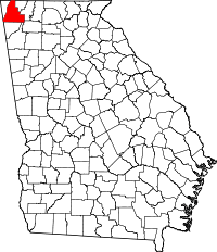 | |
| CDPs | ||
| Unincorporated communities | ||
| Ghost town | ||
| Footnotes | ‡This populated place also has portions in an adjacent county or counties | |