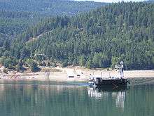
Needles Ferry

The Needles Ferry is a cable ferry across Lower Arrow Lake in British Columbia, Canada. It is situated 59 kilometres (37 mi) south of Nakusp and links Needles and Fauquier.[1]
Operation
The ferry operates under contract to the British Columbia Ministry of Transportation and is free of tolls. It travels back and forth every thirty minutes, from the first departure at 5am until the last departure at 10pm, with a crossing time of about five minutes. The ferry has capacity for 30 vehicles and 144 passengers.[1]
The ferry is diesel powered and pulls using a winding drum on a pair of 1-inch-diameter (25 mm) cables, plastic coated to prevent wear, which are suspended in the lake. The crossing is about 1 kilometre (0.62 mi) in length.
History
A ferry has been in operation from Needles since 1913.[2] Early farmers built the first ferry using Ford Model T parts. A small community in Needles, which pre-dated the ferry, was an area of fruit trees and scrub farming. Farmers provided fruit and vegetables to the mines of the Lardeau district (between Upper Arrow Lake and the head of Kootenay Lake). Canadian Pacific Railway lake steamers connected the farms to Arrowhead and Robson. The valley was flooded in the late 1960s by the construction of the Hugh Keenleyside Dam at Castlegar in the 1960s, leading people to abandon the town, after being expropriated from the lakeshore by Hydro. The ferry landing and a small cemetery are all that remain.[3]
Fauquier is the "centre" of the area that includes Edgewood and Burton with a few houses, gas station and grocery store.
See also
References
- 1 2 "Inland Ferry Schedules". Province of British Columbia. Retrieved 2008-11-25.
- ↑ Marquardt, Riel (2006). The Backroad Chronicles: Adventure & History in British Columbia. Vol. I. Trafford Publishing. p. 101. ISBN 978-1-4120-5903-9.
- ↑ Needles Cemetery
External links
- Needles Ferry Schedule at the BC Ministry of Transportation
- Needles Ferry Crossing at Wikimapia
- "Needles". BC Geographical Names.
Coordinates: 49°52′24″N 118°06′03″W / 49.87333°N 118.10083°W