Neman, Russia
| Neman (English) Неман (Russian) | |
|---|---|
| - Town[1] - | |
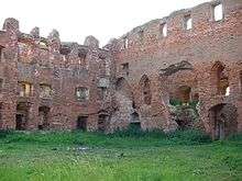
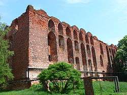 Castle ruins | |
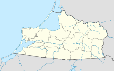
.svg.png) Location of Kaliningrad Oblast in Russia | |
 Neman | |
|
| |
| Administrative status (as of November 2011) | |
| Country | Russia |
| Federal subject | Kaliningrad Oblast[1] |
| Administrative district | Nemansky District[1] |
| Town of district significance | Neman[1] |
| Administrative center of | Nemansky District,[1] town of district significance of Neman[1] |
| Municipal status (as of February 2013) | |
| Municipal district | Nemansky Municipal District[2] |
| Urban settlement | Nemanskoye Urban Settlement[2] |
| Administrative center of | Nemansky Municipal District,[2] Nemanskoye Urban Settlement[2] |
| Statistics | |
| Population (2010 Census) | 11,798 inhabitants[3] |
| Time zone | USZ1 (UTC+02:00)[4] |
| Founded | 1288[5] |
| Previous names | Ragnit (until 1946)[5] |
| Postal code(s)[6] | 238710, 238711 |
| Dialing code(s) | +7 40162 |
| Neman on Wikimedia Commons | |
Neman (Russian: Неман), prior to 1946 known by its German name Ragnit (Lithuanian: Ragainė; Polish: Ragneta) is a town and the administrative center of Nemansky District in Kaliningrad Oblast, Russia, located in the historic East Prussia, on the steep southern bank of the Neman River, where it forms the Russian border with the Klaipėda Region in Lithuania, and 130 kilometers (81 mi) northeast of Kaliningrad, the administrative center of the oblast. Population: 11,798 (2010 Census);[3] 12,714 (2002 Census);[7] 13,821 (1989 Census).[8]
History
![]() Teutonic Order 1288–1466
Teutonic Order 1288–1466
![]() Teutonic Order 1466–1525 (fief of Poland)
Teutonic Order 1466–1525 (fief of Poland)
![]() Duchy of Prussia 1525–1657 (fief of Poland)
Duchy of Prussia 1525–1657 (fief of Poland)
![]() Duchy of Prussia 1657–1701
Duchy of Prussia 1657–1701
![]() Kingdom of Prussia 1701–1871
Kingdom of Prussia 1701–1871
![]() German Empire 1871–1918
German Empire 1871–1918
![]() Weimar Republic 1918–1933
Weimar Republic 1918–1933
![]() Nazi Germany 1933–1945
Nazi Germany 1933–1945
![]() Soviet Union 1945–1991
Soviet Union 1945–1991
![]() Russian Federation 1991–present
Russian Federation 1991–present
Ragnita (from Old Prussian: ragas, "spur"), founded in 1288,[5] was a settlement of the Baltic (Old Prussian) tribe of Skalvians. It was contested by the Grand Duchy of Lithuania since its creation in the 13th century, and on April 23, 1289 it was conquered by the Teutonic Knights, who built a Gothic castle there, which later became the seat of a Komtur. The stronghold was called Landeshut, but the name did not become popular and the name Ragnit, after a local river, a tributary of the Memel (outside of Prussia called Neman), continued to be used.
Although the settlement had an important castle not only guarding the Prussian lands of the State of the Teutonic Order from the north but also serving as a military base for the Knights' campaigns into adjacent Samogitia, it was living in the shadow of the nearby city of Tilsit (present-day Sovetsk). After the dissolution of the Order's State under its last Grand Master Albrecht von Hohenzollern, Ragnit on April 10, 1525 became a part of the Duchy of Prussia, which was ruled by the House of Hohenzollern as a fief of the Polish Crown until 1657. The duchy was inherited by the Hohenzollern margraves of Brandenburg in 1618, becoming an integral part of Brandenburg-Prussia, whereby remote Ragnit retained its status as a regional capital.
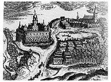
Ragnit was devastated by Tatars during the Second Northern War in 1656 and again by Swedish forces during the Scanian War in 1678, while the "Great Elector" Frederick William of Brandenburg had achieved full sovereignty over his Prussian lands by the 1657 Treaty of Wehlau. His son and successor Elector Frederick III elevated himself to a King in Prussia in 1701. He granted Ragnit town privileges on April 6, 1722. It was again destroyed during the Seven Years' War, this time by Russian forces in 1757.
Incorporated into the Province of East Prussia from 1815, Ragnit became a part of the German Empire upon the Prussian-led unification of Germany in 1871. On November 1, 1892, a railroad line linking the town with Tilsit (now Sovetsk) was opened. It was built to develop the wood industry in the area, but the development did not actually start and the area's economy remained dominated by food production. When Germany had to cede the Klaipėda Region north of the Neman River to the Conference of Ambassadors according to the 1919 Treaty of Versailles, Ragnit became a border town. In 1922, it lost its status as an administrative capital in favor of Tilsit.
During World War II, on January 19, 1945, Ragnit was captured without a fight by the 3rd Belorussian Front of the Red Army in the course of the East Prussian Offensive. According to the 1945 Potsdam Agreement, the town became a part of Kaliningrad Oblast of the Russian SFSR. It was renamed Neman in 1946.[5] Most of the local inhabitants who had not fled during the Soviet conquest of East Prussia were subsequently expelled to the western parts of Germany.
Administrative and municipal status
Within the framework of administrative divisions, Neman serves as the administrative center of Nemansky District.[1] As an administrative division, it is, together with nineteen rural localities, incorporated within Nemansky District as the town of district significance of Neman.[1] As a municipal division, the town of district significance of Neman is incorporated within Nemansky Municipal District as Nemanskoye Urban Settlement.[2]
Lithuanian minority
Despite being a part of German-speaking states, for centuries Ragnit was an important center of Lithuanian culture. From 1549 to 1563, famous Lithuanian writer and translator (who wrote the first book in the Lithuanian language, "Catechismusa Prasty Szadei" ("The Simple Words of Catechism")) Martynas Mažvydas was priest and Archdiacon of Ragainė. While living in Ragainė he wrote "The Song of St. Ambrosy" (with a dedication in Lithuanian), translated "The Form of Baptism" from German into Lithuanian, published "The Prussian Agenda" into the prayer "Paraphrasis". One of his major works was "The Christian Songs" (Giesmės Krikščioniškos). In the 19th century, after the January Uprising when the Lithuanian language was banned from the office in all of Russian-ruled Lithuania, books in that language were printed in Ragnit and then smuggled to Russia by the Lithuanian book smugglers (knygnešiai). According to German data 17,500 Lithuanians lived in the Ragnit district in 1890 (32% of the population).[9] In 2010 Lithuanians composed 2,8% of the town population, being the third largest ethnic group after Russians and Belarusians.
Notable people
- Julius Bacher (1810–1889), German novelist
- Walter Bruno Henning (1908–1967), German scholar
- Martynas Jankus (1858-1946), Lithuanian printer, publicist
- Erich Klossowski (1875-1949), German-Polish art historian, painter
- Martynas Mažvydas (1510–1563), Lithuanian priest, writer, translator
- Johann Friedrich Reiffenstein (1719–1793), German painter, antiquarian
International relations
Twin towns and sister cities
Neman is twinned with:
See also
References
Notes
- 1 2 3 4 5 6 7 8 Resolution #640
- 1 2 3 4 5 Law #257
- 1 2 Russian Federal State Statistics Service (2011). "Всероссийская перепись населения 2010 года. Том 1" [2010 All-Russian Population Census, vol. 1]. Всероссийская перепись населения 2010 года (2010 All-Russia Population Census) (in Russian). Federal State Statistics Service. Retrieved June 29, 2012.
- ↑ Правительство Российской Федерации. Федеральный закон №107-ФЗ от 3 июня 2011 г. «Об исчислении времени», в ред. Федерального закона №271-ФЗ от 03 июля 2016 г. «О внесении изменений в Федеральный закон "Об исчислении времени"». Вступил в силу по истечении шестидесяти дней после дня официального опубликования (6 августа 2011 г.). Опубликован: "Российская газета", №120, 6 июня 2011 г. (Government of the Russian Federation. Federal Law #107-FZ of June 31, 2011 On Calculating Time, as amended by the Federal Law #271-FZ of July 03, 2016 On Amending Federal Law "On Calculating Time". Effective as of after sixty days following the day of the official publication.).
- 1 2 3 4 Энциклопедия Города России. Moscow: Большая Российская Энциклопедия. 2003. p. 294. ISBN 5-7107-7399-9.
- ↑ Почта России. Информационно-вычислительный центр ОАСУ РПО. (Russian Post). Поиск объектов почтовой связи (Postal Objects Search) (Russian)
- ↑ Russian Federal State Statistics Service (May 21, 2004). "Численность населения России, субъектов Российской Федерации в составе федеральных округов, районов, городских поселений, сельских населённых пунктов – районных центров и сельских населённых пунктов с населением 3 тысячи и более человек" [Population of Russia, Its Federal Districts, Federal Subjects, Districts, Urban Localities, Rural Localities—Administrative Centers, and Rural Localities with Population of Over 3,000] (XLS). Всероссийская перепись населения 2002 года [All-Russia Population Census of 2002] (in Russian). Retrieved August 9, 2014.
- ↑ Demoscope Weekly (1989). "Всесоюзная перепись населения 1989 г. Численность наличного населения союзных и автономных республик, автономных областей и округов, краёв, областей, районов, городских поселений и сёл-райцентров" [All Union Population Census of 1989: Present Population of Union and Autonomous Republics, Autonomous Oblasts and Okrugs, Krais, Oblasts, Districts, Urban Settlements, and Villages Serving as District Administrative Centers]. Всесоюзная перепись населения 1989 года [All-Union Population Census of 1989] (in Russian). Институт демографии Национального исследовательского университета: Высшая школа экономики [Institute of Demography at the National Research University: Higher School of Economics]. Retrieved August 9, 2014.
- ↑ http://www.verwaltungsgeschichte.de/tilsit.html
Sources
- Правительство Калининградской области. Постановление №640 от 30 августа 2011 г. «Об утверждении реестра объектов административно-территориального деления Калининградской области», в ред. Постановления №877 от 21 ноября 2011 г «О внесении изменения в Постановление Правительства Калининградской области от 30 августа 2011 г. №640». Вступил в силу со дня официального опубликования. Опубликован: "Калининградская правда" (вкладыш "Официально"), №170, 15 сентября 2011 г. (Government of Kaliningrad Oblast. Resolution #640 of August 30, 2011 On the Adoption of the Registry of the Objects of the Administrative-Territorial Divisions of Kaliningrad Oblast, as amended by the Resolution #877 of November 21, 2011 On Amending the Resolution of the Government of Kaliningrad Oblast #640 of August 30, 2011. Effective as of the day of the official publication.).
- Калининградская областная Дума. Закон №257 от 30 июня 2008 г. «Об организации местного самоуправления на территории муниципального образования "Неманский городской округ"», в ред. Закона №89 от 15 февраля 2012 г «О внесении изменений в Закон Калининградской области "Об организации местного самоуправления на территории муниципального образования "Неманский городской округ"». Вступил в силу со дня официального опубликования. Опубликован: "Калининградская правда", №124, 11 июля 2008 г. (Kaliningrad Oblast Duma. Law #257 of June 30, 2008 On the Organization of the Local Self-Government on the Territory of the Municipal Formation of "Nemansky Urban Okrug", as amended by the Law #89 of February 15, 2012 On Amending the Law of Kaliningrad Oblast "On the Organization of the Local Self-Government on the Territory of the Municipal Formation of "Nemansky Urban Okrug". Effective as of the day of the official publication.).
External links
- Unofficial website of Neman (Russian)
Administrative divisions of Kaliningrad Oblast (former German names are given in parentheses and italicized) | ||
|---|---|---|
Administrative center: Kaliningrad (Königsberg) | ||
| Cities and towns |
| |
| Urban-type settlements of oblast significance |
| |
| Districts | ||