Svetly, Kaliningrad Oblast
| Svetly (English) Светлый (Russian) | |
|---|---|
| - Town[1] - | |
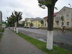 Soviet Street | |
.svg.png) Location of Kaliningrad Oblast in Russia | |
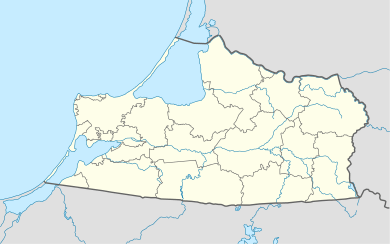 Svetly | |
|
| |
.png) | |
|
| |
| Administrative status (as of November 2011) | |
| Country | Russia |
| Federal subject | Kaliningrad Oblast[1] |
| Administratively subordinated to | town of oblast significance of Svetly[1] |
| Administrative center of | town of oblast significance of Svetly[1] |
| Municipal status (as of July 2009) | |
| Urban okrug | Svetlovsky Urban Okrug[2] |
| Administrative center of | Svetlovsky Urban Okrug[2] |
| Statistics | |
| Population (2010 Census) | 21,375 inhabitants[3] |
| Time zone | USZ1 (UTC+02:00)[4] |
| Founded | 1640 |
| Town status since | 1955 |
| Postal code(s)[5] | 238340, 238741 |
| Svetly on Wikimedia Commons | |
Svetly (Russian: Све́тлый), prior to 1945 known by its German name Zimmerbude (Lithuanian: Cimerbūdė; Polish: Buda), is a town in Kaliningrad Oblast, Russia, located on the Samland Peninsula on the coast of Vistula Lagoon, 30 kilometers (19 mi) west of Kaliningrad, the administrative center of the oblast. Population: 21,375 (2010 Census);[3] 21,745 (2002 Census);[6] 19,936 (1989 Census).[7]
Geography
The town is located on the bank of the Kaliningrad sea shipping channel connecting Kaliningrad with the Baltic Sea.
History
![]() Duchy of Prussia 1640–1657 (fief of Poland)
Duchy of Prussia 1640–1657 (fief of Poland)
![]() Duchy of Prussia 1657–1701
Duchy of Prussia 1657–1701
![]() Kingdom of Prussia 1701–1871
Kingdom of Prussia 1701–1871
![]() German Empire 1871–1918
German Empire 1871–1918
![]() Weimar Republic 1918–1933
Weimar Republic 1918–1933
![]() Nazi Germany 1933–1945
Nazi Germany 1933–1945
![]() Soviet Union 1945–1991
Soviet Union 1945–1991
![]() Russian Federation 1991–present
Russian Federation 1991–present
It was founded in 1640 as Zimmerbude and was a part of East Prussia until 1945. In 1947, it was renamed Svetly. Town status was granted to it in 1955.
The first mention of its predecessor - the settlement dates back to the 15th-century Tsimmerbude chronicle German knight of the Order. But earlier, in Fishhauzen manuscript 1305 and (Germany), mention of the peninsula Payziev ("Poyzart" - the area in the forest Poyz), by which in the first half of the 13th century German knights invaded the land Prussians. No filed ramparts of the castle once stood here "Royal Manor fishing", erected in the middle of the 15th century and belonged Samland first bishop. After the confiscation of church property to the estate passed into the possession of Oswald von Taubenhaym, which belonged to the most illustrious nobility and owned Zemland Tsimmerbude until 1661 as well.
In 1669 at the manor was given to the former tutor of King Frederick I Ebenhard Dankelman background as a reward.
In about 1720 and Tsimmerbude included, along with 16 plots of land, 12 peasants and about the same number of fishermen whose main occupation was fishing, mainly for their own needs.
Gradually lock destroyed time and waters of the Gulf, but the memory of it still continued to live in any generation.
After the castle ceased to exist for a long time villagers eked out a miserable existence. Were poor, fed by fishing, which has never provided them nourishing life. Apart from a few acidified meadows they had no land, and therefore almost never held cattle. Their home were extremely cramped and dirty, smoke coming out of the centers through kamyshoyve roof sagged and a thick layer of soot on the walls through the kitchen. Long winter evenings in the huts burning torch, making the faces of the inhabitants were constantly black. Clothes spun, wove, and sewed himself. This adds another life flood, which were repeated from year to year.
Important role in the life of the village occupied religion: conducting religious rites, services, etc. For a long time there was no Tsimmerbude in his church and the village belonged to the parish church Medena (Logvino). But because of bad roads to visit the church in Medena villagers could only a few times in my life, there was baptized children, married, went on the biggest holidays in good weather. The rest of the strongly expressed religious feelings of people meet as a church sermons, which were held in the school building. And from April 1, 1901 and Tsimmerbude with neighboring villages and Payziev Nepleken 1500 residents formed their own church community and bought a small church, which two years earlier Medena built in Tsimmerbude as its branch.
In the 1920s Tsimmerbude built a new school and even before World War II Tsimmerbude was a pretty busy, though small village. Here was his shop, restaurant, bakery. And was hotel entitled "Valdshloskhen" translated "Forest castle house". Was also its church. Number of pre-war inhabitants Tsimmerbude was 742 people.
During World War II directly to the modern city of Bright military action did not pass. War for Tsimmerbude ended in April 1945 and, leaving extensive damage.
In 1947 at Tsimmerbude was renamed to the Svetly. June 17, 1947 and decreeth Presidium of the Supreme Soviet of the RSFSR as part of the Primorsky district was formed with the Countryside Council center in the village Svetly (former settlement Tsimmerbude) that decision Kaliningrad Oblast Executive Committee for the number 758 of 1 August 1949 and was converted into a working village Svetly. October 6, 1955 and the Presidium of the Supreme Soviet of the working village was transformed into a Svetly, town Svetly district subordination, which since the 2008 and the center of the municipality "Svetlovsky Borough".
Administrative and municipal status
Within the framework of administrative divisions, it is, together with ten rural localities, incorporated as the town of oblast significance of Svetly—an administrative unit with the status equal to that of the districts.[1] As a municipal division, the town of oblast significance of Svetly is incorporated as Svetlovsky Urban Okrug.[2]
Climate
The climate is influenced by the prevailing air mass with Atlantic Ocean to the mainland and is characterized as a transition to the sea with mild winters with little snow, relatively cold spring, moderately warm summers and warm wet autumn. Average annual air temperature - 6.8 °C (44.2 °F). The annual temperature range can reach large sizes - from + 35 °C (95 °F) in July - August to −33 °C (−27 °F) in January - February.
The average temperature in January - −3.4 °C (25.9 °F). There are 86 days per year with frost. Severe frosts are rare. The warmest period - the month of July, when the average temperature is 17.5 °C (63.5 °F). In general, unstable weather patterns and is associated mainly with a predominance of marine air masses with high repeatability accompanying Cyclones (storms).
Moist air masses coming from the Atlantic Ocean, cause high relative humidity, which is winter and fall 85-87 %, decreasing by early summer to 72-73 %. High humidity and a large cloudy significantly affect the features (reduction) of the Svetly regime.
During the year, is celebrated around 150 overcast and only 30 clear days. In an average year recorded 74 days with fogs, mainly fogs in winter. They are accompanied by drizzle, rain and snow. And annual rainfall of up to 700–750 mm (27.6–29.5 in) of rainfall, most of them in the warmer months. The maximum is in the month of August - up to 90 mm (4 in), at least - in February - March. In the winter months falls only 8-10% of annual precipitation. Snow depth is small - 13–18 cm (5–7 in).
The study area generally refers to the area of active wind activity. The wind regime is characterized by a predominance of winds south, western areas with a repeatability of 35%, as well as the southern and south -eastern areas with a repeatability of 23%. The average annual wind speed is 3.7 metres per second (12.1 ft/s). Has the highest rate of wind. In winter, its average speed is 5.5 m/s (18.0 ft/s). The number of days with strong winds (storms) at speeds exceeding 15 m/s (49.2 ft/s) up to 10–15 days.
Economy
- "Lukoil - Kaliningradmorneft": oil terminal (storage, transfer of liquid petroleum products), steel plant (production of marine steel structures);
- JSC "Sodrujestvo -Soja" - deep processing of oil-bearing crops;
- JSC "Jantarenergo" (GRES - 2) - heat production;
- LLC «Vivo-Porte» - production of interior doors;
- OOO "Optim - Kran" - production support and overhead cranes;
- OOO "Regio - Express" - passenger transport;
- Rybkolhoz "Za Rodinu" - fishing and fish processing;
- JSC "Svetly predprijatie "Era" - produces electrical work, repair of electrical equipment, electrical parameter measurements, ship repair river and maritime registers;
- OGUP "Zapremmash" - ship repair and manufacturing, fish processing equipment;
- JSC "Mezhkolhoznaja proizvodstvennaja baza" - ship repair, port services, maintenance and supply of the fishing fleet;
- JSC "Sudoremontnik Baltica" - ship repair, port services;
- JSC "BaltNafta" - handling of oil products;
- OOO "Kreon" - shredding fish canned;
Transportation
The station is located in svetly Baltic Forest Kaliningrad railway. The station belongs to a dead-end branch branched from the railway line Kaliningrad - Baltiysk. As of 2009 Svetly is not served by passenger trains. Distance to Kaliningrad - 27.5 km (17.1 mi), airport Hrabrovo - 38 km (24 mi).
Sights
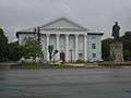 House of Culture and Monument to Lenin.
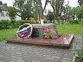 Monument to the liquidators of the Chernobyl accident.
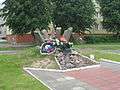 Monument to soldiers-internationalists.
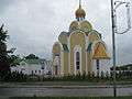 Temple of the Holy Great Martyr Barbara.
- Church of the Annunciation
- Temple of the Holy Great Martyr Barbara.
- Monument to Lenin.
- Monument to soldiers-internationalists.
- Monument to the liquidators of the Chernobyl accident.
- Church of the Apostles Paul and Gleb.
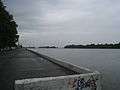 Kaliningrad Sea Canal and the port in Svetly.
Notable people
- Eberhard von Danckelmann - Brandenburg statesman.
- Matveev, Maxim - Russian film and theater actor.
- Evans, Edgar Yanisovich - master of sports of international class rowing sports.
- Dmitri Rozinkevich - Honored Master of Sports of Russia.
- Bokhonov, Victor F. - Soviet and Russian actor of theater, film and dubbing.
Twin towns and sister cities
Svetly is twinned with:
 Kętrzyn, Poland
- Świnoujście, Poland
- Nowy Dwór Gdański, Poland
 Lida, Belarus
 Karlshamn, Sweden
References
Notes
- 1 2 3 4 5 Resolution #639
- 1 2 3 Law #423
- 1 2 Russian Federal State Statistics Service (2011). "Всероссийская перепись населения 2010 года. Том 1" [2010 All-Russian Population Census, vol. 1]. Всероссийская перепись населения 2010 года (2010 All-Russia Population Census) (in Russian). Federal State Statistics Service. Retrieved June 29, 2012.
- ↑ Правительство Российской Федерации. Федеральный закон №107-ФЗ от 3 июня 2011 г. «Об исчислении времени», в ред. Федерального закона №271-ФЗ от 03 июля 2016 г. «О внесении изменений в Федеральный закон "Об исчислении времени"». Вступил в силу по истечении шестидесяти дней после дня официального опубликования (6 августа 2011 г.). Опубликован: "Российская газета", №120, 6 июня 2011 г. (Government of the Russian Federation. Federal Law #107-FZ of June 31, 2011 On Calculating Time, as amended by the Federal Law #271-FZ of July 03, 2016 On Amending Federal Law "On Calculating Time". Effective as of after sixty days following the day of the official publication.).
- ↑ Почта России. Информационно-вычислительный центр ОАСУ РПО. (Russian Post). Поиск объектов почтовой связи (Postal Objects Search) (Russian)
- ↑ Russian Federal State Statistics Service (May 21, 2004). "Численность населения России, субъектов Российской Федерации в составе федеральных округов, районов, городских поселений, сельских населённых пунктов – районных центров и сельских населённых пунктов с населением 3 тысячи и более человек" [Population of Russia, Its Federal Districts, Federal Subjects, Districts, Urban Localities, Rural Localities—Administrative Centers, and Rural Localities with Population of Over 3,000] (XLS). Всероссийская перепись населения 2002 года [All-Russia Population Census of 2002] (in Russian). Retrieved August 9, 2014.
- ↑ Demoscope Weekly (1989). "Всесоюзная перепись населения 1989 г. Численность наличного населения союзных и автономных республик, автономных областей и округов, краёв, областей, районов, городских поселений и сёл-райцентров" [All Union Population Census of 1989: Present Population of Union and Autonomous Republics, Autonomous Oblasts and Okrugs, Krais, Oblasts, Districts, Urban Settlements, and Villages Serving as District Administrative Centers]. Всесоюзная перепись населения 1989 года [All-Union Population Census of 1989] (in Russian). Институт демографии Национального исследовательского университета: Высшая школа экономики [Institute of Demography at the National Research University: Higher School of Economics]. Retrieved August 9, 2014.
Sources
- Правительство Калининградской области. Постановление №640 от 30 августа 2011 г. «Об утверждении реестра объектов административно-территориального деления Калининградской области», в ред. Постановления №877 от 21 ноября 2011 г «О внесении изменения в Постановление Правительства Калининградской области от 30 августа 2011 г. №640». Вступил в силу со дня официального опубликования. Опубликован: "Калининградская правда" (вкладыш "Официально"), №170, 15 сентября 2011 г. (Government of Kaliningrad Oblast. Resolution #640 of August 30, 2011 On the Adoption of the Registry of the Objects of the Administrative-Territorial Divisions of Kaliningrad Oblast, as amended by the Resolution #877 of November 21, 2011 On Amending the Resolution of the Government of Kaliningrad Oblast #640 of August 30, 2011. Effective as of the day of the official publication.).
- Калининградская областная Дума. Закон №423 от 11 октября 2004 г. «О наделении муниципального образования "Светловский городской округ" статусом городского округа», в ред. Закона №370 от 1 июля 2009 г «О составе территорий муниципальных образований Калининградской области». Вступил в силу со дня официального опубликования. Опубликован: "Российская газета" ("Запад России"), №236, 26 октября 2004 г. (Kaliningrad Oblast Duma. Law #423 of October 11, 2004 On Granting the Urban Okrug Status to the Municipal Formation of "Svetlovsky Urban Okrug", as amended by the Law #370 of July 1, 2009 On the Composition of the Territories of the Municipal Formations of Kaliningrad Oblast. Effective as of the day of the official publication.).
Administrative divisions of Kaliningrad Oblast (former German names are given in parentheses and italicized) | ||
|---|---|---|
Administrative center: Kaliningrad (Königsberg) | ||
| Cities and towns |
| |
| Urban-type settlements of oblast significance |
| |
| Districts | ||