New York State Route 218
| ||||
|---|---|---|---|---|
|
Map of Orange County in southeastern New York with NY 218 highlighted in red | ||||
| Route information | ||||
| Maintained by NYSDOT | ||||
| Length: | 10.81 mi[1] (17.40 km) | |||
| Existed: | early 1940s[2][3] – present | |||
| Major junctions | ||||
| South end: |
| |||
| North end: |
| |||
| Location | ||||
| Counties: | Orange | |||
| Highway system | ||||
| ||||


New York State Route 218 (NY 218) is a state highway located within Orange County, New York, in the United States. It loops off U.S. Route 9W to run closer to the Hudson River between Highland Falls and Cornwall-on-Hudson. North of Highland Falls, it is briefly concurrent with US 9W.
NY 218 sees much traffic despite its short length. Not only does it bring most of the United States Military Academy's traffic to Thayer Gate, its main entrance, it attracts many who drive it just for the sake of its most renowned portion: the cliffside drive alongside Storm King Mountain. In good weather during the summer months many cars can be seen taking in the views of the river and the Hudson Highlands here (however, this section can be gated off and closed in times of high rockslide danger).
Route description
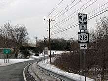
NY 218 begins at a trumpet interchange with flyover ramps with US 9W in the village of Highland Falls near the former site of Fort Montgomery. NY 218 proceeds northeast through the village as a two lane village street, turning northward at an intersection with Old State Road. NY 218 proceeds north, crossing a large residential section of Highland Falls bending northeast then north before intersecting with West Point Highway. A short distance to the north in Highland Falls, NY 218 bends west on an intersection with Mill Street and Mountain Avenue, where NY 218 turns west on Mountain Avenue, a two-lane commercial/residential street through Highland Falls. Passing west of Highland Falls Intermediate School, the route bends northward around a small section of the United States Military Academy at West Point.[4]
NY 218 winds through Highland Falls, leaving the downtown section of the village, entering an interchange with US 9W and Stony Lonesome Road. Stony Lonesome Road connects US 9W and NY 218 to West Point's Stony Lonesome Gate, while NY 218 merges with US 9W northbound, forming a concurrency. Now in the town of Highlands, NY 218 and US 9W wind northwest as a four-lane boulevard through the West Point Golf Course, where NY 218 forks off at an interchange that also doubles as the northern terminus of NY 293. Now on the right-of-way ceded from NY 293, NY 218 parallels US 9W as a two-lane road running along the northwestern side of the golf course. After the golf course, the route intersects with Washington Road. Washington Road connects NY 218 to West Point via Washington Gate, while NY 218 proceeds north through Highlands.[4]
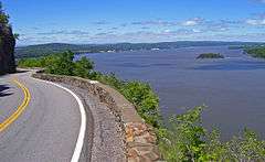
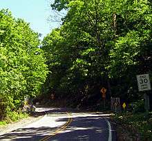
NY 218 winds north and northwest along the border of West Point, crossing through a section of the military academy. As the route approaches the Hudson River, it bends northward as the Storm King Highway, paralleling the river and the CSX Transportation-owned River Subdivision (ex-West Shore Line). A short distance to the north, the route crosses a gate and enters Storm King State Park. Making a large bend around a rock base, NY 218 approaches the Hudson River, overlooking the river and railroad tracks below. The route winds northwest for several miles alongside the rock siding, crossing into the town of Cornwall, where the route turns west and away from the river. Crossing through a dense section of woods, the route makes several bends through Storm King State Park, re-approaching the river a short distance to the north.[4]
NY 218 turns westward again in Cornwall, crossing into the village of Cornwall-on-Hudson. A short distance to the east, NY 218 crosses out of Storm King State Park and crosses gates that close the roadway. Now known as Bay View Avenue, NY 218 is a two-lane residential street through Cornwall-on-Hudson, proceeding west through the village. At Dock Hill Extension, NY 218 darts north and changes streets to Hudson Street, where it continues westward. Hudson Street is more commercial than Bay View Avenue and after entering the downtown section of Cornwall-on-Hudson, NY 218 darts westward on Hudson, while Idlewild Avenue continues northwest on the former right-of-way. The section of NY 218 west of Idlewild is residential before intersecting with Academy Avenue, where NY 218 turns off of Hudson Street.[4]
NY 218 continues northwest through Cornwall-on-Hudson on Academy Avenue, remaining a two-lane residential street through the village. At the intersection with County Route 9 (CR 9; Main Street, formerly the northern terminus of NY 307), NY 218 proceeds northwest again, entering an interchange with US 9W. Now back in the town of Cornwall, NY 218 terminates at this interchange with US 9W.[4]
History
In 1908, the New York State Legislature created Route 3, an unsigned legislative route extending from the New Jersey state line in Rockland County to Albany by way of the Hudson River's west bank. The route mostly followed what is now U.S. Route 9W; however, from Highland Falls to Cornwall-on-Hudson, it used modern NY 218 instead.[5][6] Much of legislative Route 3 became part of NY 10 when the first set of posted routes in New York were assigned in 1924[7][8] and part of US 9W when it was originally assigned in 1927.[9]
In the early 1930s, plans were made by the state of New York to construct a new highway between the Bear Mountain Bridge and Cornwall-on-Hudson that would bypass both Cornwall-on-Hudson and Highland Falls and bypass the narrow Storm King Highway. On April 8, 1934, three people were killed by a rockslide on the Storm King Highway, expediting plans for the new highway, known as the Storm King Cut-off. It was constructed in stages from 1937 to 1941,[10][11] with the final segment of the highway (from Angola Road north to Blooming Grove Turnpike north of Cornwall-on-Hudson) opening to traffic on May 31, 1941. US 9W was realigned to follow the cut-off[12] while its old route via the Storm King Highway became NY 218.[2]
During the forest fires on Storm King during the summer of 1999, NY 218 was closed for over a year, reopening in August 2000.[13]
Major intersections
The entire route is in Orange County.
| Location | mi[1] | km | Destinations | Notes | |
|---|---|---|---|---|---|
| Highland Falls | 0.00 | 0.00 | |||
| Highlands | 2.45 | 3.94 | Trumpet interchange; southern terminus of US 9W / NY 218 overlap | ||
| 3.21 | 5.17 | Interchange; northern terminus of NY 293; northern terminus of US 9W / NY 218 overlap | |||
| Cornwall | 9.90 | 15.93 | Former eastern terminus of NY 307 | ||
| 10.81 | 17.40 | ||||
1.000 mi = 1.609 km; 1.000 km = 0.621 mi
| |||||
See also
.svg.png) New York Roads portal
New York Roads portal Hudson Valley portal
References
- 1 2 "2008 Traffic Volume Report for New York State" (PDF). New York State Department of Transportation. June 16, 2009. p. 189. Retrieved February 1, 2010.
- 1 2 New York with Pictorial Guide (Map). Cartography by General Drafting. Esso. 1942.
- ↑ New York (Map). Cartography by General Drafting. Esso. 1940.
- 1 2 3 4 5 Microsoft; Nokia (August 3, 2012). "overview map of NY 218" (Map). Bing Maps. Microsoft. Retrieved August 3, 2012.
- ↑ State of New York Department of Highways (1909). The Highway Law. Albany, New York: J. B. Lyon Company. p. 54. Retrieved July 12, 2010.
- ↑ New York State Department of Highways (1920). Report of the State Commissioner of Highways. Albany, New York: J. B. Lyon Company. pp. 499–500. Retrieved July 12, 2010.
- ↑ "New York's Main Highways Designated by Numbers". The New York Times. December 21, 1924. p. XX9.
- ↑ Official Map Showing State Highways and other important roads (Map). Cartography by Rand McNally and Company. State of New York Department of Public Works. 1926.
- ↑ Automobile Blue Book. 1 (1927 ed.). Chicago: Automobile Blue Book, Inc. 1927. This edition shows U.S. Routes as they were first officially signed in 1927.
- ↑ Mathieu, George M. (August 6, 1939). "Storm King Cut-Off Pushed". The New York Times. pp. XX1, XX10.
- ↑ "Route U.S. 9W Improved". The New York Times. November 21, 1937. p. 196.
- ↑ Mathieu, George M. (May 25, 1941). "A Cut-Off With Views". The New York Times. p. XX2.
- ↑ Hall, Wayne (August 26, 2000). "Route 218 back in business". Times-Herald Record. Ottaway Community Newspapers. Retrieved August 3, 2012.
Route 218, a popular shortcut to the U.S. Military Academy at West Point, reopened yesterday at 1:45 p.m. for the evening rush after being closed for more than a year of repairs ... Hundreds of people use the road daily to get to work at West Point
External links
| Wikimedia Commons has media related to New York State Route 218. |
- New York State Route 218 at Alps' Roads • New York Routes • New York State Highway Termini