Newark Plank Road
The Newark Plank Road was a major artery between Hudson Waterfront at Paulus Hook (in today's Jersey City) and city of Newark further inland across the New Jersey Meadows. As its name suggests, a plank road was constructed of wooden planks laid side-to-side on a roadbed. Similar roads, the Bergen Point Plank Road, the Hackensack Plank Road and Paterson Plank Road, travelled to the locales for which they are named. The name is no longer used, the route having been absorbed into other streets and freeways.
In 1765, an act of the Assembly of the Province of New Jersey stated:
A road from New-Ark to the publick road in the town of Bergen, leading to Poulos Hook, and establishing ferries over the two small rivers, Passaick and Hackensack, which makes the distance from Poulus Hook to New-Ark eight miles, and will be a level and good road when the cause-ways are made ; and as said road will be very commodious for travelers, and give a short and easy access of a large country to the markets of the city of New-York and be of a general benefit both to city and country, it is hoped they will unite in the necessary expence of rendering said road for travellers and carriages, more especially since by said law the publick interest alone is regarded.[1]
A corporation sanctioned by the legislation to build a road and bridges over the Hackensack River and Passaic River as part of the developing colonial road network in New Jersey was established. Initially ferry service was instituted at the river crossings which operated until the bridges were completed in 1795.[2]
A charter to operate the road was granted on February 24, 1849 and it was renamed Newark Plank Road.[3] By 1869 Central Railroad of New Jersey's Newark and New York Railroad was running trains that mirrored the route. (The right of way through Bergen Hill is now used by Hudson-Bergen Light Rail West Side Branch). Public Service Railway Lines #1 ran along much of route until bustitution was implemented, keeping the old number now used by New Jersey Transit as part of the #1 bus route.
Jersey City
![]()
![]()
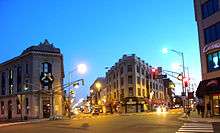
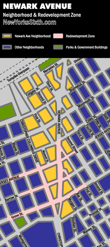
![]() Newark Avenue in Jersey City begins at Grove Street,[4] the stretch connecting it to the waterfront at Exchange Place/Paulus Hook called Railroad Avenue, after the Jersey City Branch of the Pennsylvania Railroad. This commercial thoroughfare in Historic Downtown borders the neighborhoods of Van Vorst Park, The Village, and Harsimus Cove.[5] Once crossing under the Newark Bay Extension of the New Jersey Turnpike it ascends Bergen Hill, between the landmarks Jersey City High School and the Jersey City and Harsimus Cemetery. The avenue enters the Five Corners district, which is the county seat of Hudson County, New Jersey, and passes Hudson County Courthouse and Administration Building. Though not called such, the area becomes a "Little Manila", due to the concentration of Filipino American businesses located there. Public Service Railway Lines #3 and #9 ran along the avenue until bustitution was implemented. As crosses Kennedy Boulevard, Newark Avenue descends and becomes the heart of the India Square neighborhood. It passes through the Marion Section running parallel to the PATH rail lines passing Mana Contemporary and under the Marion Junction lines. Here Newark Avenue diverges from the colonial route and crosses the Wittpenn Bridge and soon thereafter splits into the Belleville Turnpike and the Newark-Jersey City Turnpike.[4][6] Newark Plank Road followed the route of U.S. Route 1/9 Truck (that now passes Holy Name Cemetery and Lincoln Park) turning onto Communipaw Avenue. After 1913 it became part of the Lincoln Highway, one of the first transcontinental automobile routes across the United States.
Newark Avenue in Jersey City begins at Grove Street,[4] the stretch connecting it to the waterfront at Exchange Place/Paulus Hook called Railroad Avenue, after the Jersey City Branch of the Pennsylvania Railroad. This commercial thoroughfare in Historic Downtown borders the neighborhoods of Van Vorst Park, The Village, and Harsimus Cove.[5] Once crossing under the Newark Bay Extension of the New Jersey Turnpike it ascends Bergen Hill, between the landmarks Jersey City High School and the Jersey City and Harsimus Cemetery. The avenue enters the Five Corners district, which is the county seat of Hudson County, New Jersey, and passes Hudson County Courthouse and Administration Building. Though not called such, the area becomes a "Little Manila", due to the concentration of Filipino American businesses located there. Public Service Railway Lines #3 and #9 ran along the avenue until bustitution was implemented. As crosses Kennedy Boulevard, Newark Avenue descends and becomes the heart of the India Square neighborhood. It passes through the Marion Section running parallel to the PATH rail lines passing Mana Contemporary and under the Marion Junction lines. Here Newark Avenue diverges from the colonial route and crosses the Wittpenn Bridge and soon thereafter splits into the Belleville Turnpike and the Newark-Jersey City Turnpike.[4][6] Newark Plank Road followed the route of U.S. Route 1/9 Truck (that now passes Holy Name Cemetery and Lincoln Park) turning onto Communipaw Avenue. After 1913 it became part of the Lincoln Highway, one of the first transcontinental automobile routes across the United States.
Kearny Point
![]() After crossing the Hackensack River on the Lincoln Highway Hackensack River Bridge the road traverses Kearny Point, the southern tip of New Barbadoes Neck where the Hackensack and Passaic River meet. It ran parallel to the Morris Canal. This section was part the transcontinental Lincoln Highway and retains that name.[4]
After crossing the Hackensack River on the Lincoln Highway Hackensack River Bridge the road traverses Kearny Point, the southern tip of New Barbadoes Neck where the Hackensack and Passaic River meet. It ran parallel to the Morris Canal. This section was part the transcontinental Lincoln Highway and retains that name.[4]

Newark
Ferry Street in the Ironbound section of Newark was part of the plank road, named after the ferry that would travel between Newark and points east. In 1849, "The Newark Plank Road Company" was hired to fix the road with planks for smoother travel. Ferry Street was then changed to "Plank Road." It was not completed within the fifty-year charter that it was given to accomplish the work. A legal dispute arose and the Hudson County section changed "Plank Road" to the Lincoln Highway while the Essex County section was changed back to "Ferry Street." [7]
Hoboken
![]() A related road is Newark Street in Hoboken which begins close to the Hoboken Terminal. For most of distance it is a narrow one-way street, after which it becomes a busy thoroughfare in the southwestern corner of town. It originally travelled to Five Corners near Journal Square. Subsequent rail and vehicular infrastructure have divided the route into several sections. A detour is created at the intersection of Observer Highway, close to which begins Paterson Plank Road. It crosses under New Jersey Transit rail operations at the city line, where again the route is diverted to accommodate the Hudson Bergen Light Rail junction. Becoming Hoboken Ave it ascends Bergen Hill where the route is interrupted by the Divided Highway, the Long Dock Tunnel and Bergen Arches. It resumes on the other side of the "cuts" for a short stretch before becoming one of the streets that creates the Five Corners.
A related road is Newark Street in Hoboken which begins close to the Hoboken Terminal. For most of distance it is a narrow one-way street, after which it becomes a busy thoroughfare in the southwestern corner of town. It originally travelled to Five Corners near Journal Square. Subsequent rail and vehicular infrastructure have divided the route into several sections. A detour is created at the intersection of Observer Highway, close to which begins Paterson Plank Road. It crosses under New Jersey Transit rail operations at the city line, where again the route is diverted to accommodate the Hudson Bergen Light Rail junction. Becoming Hoboken Ave it ascends Bergen Hill where the route is interrupted by the Divided Highway, the Long Dock Tunnel and Bergen Arches. It resumes on the other side of the "cuts" for a short stretch before becoming one of the streets that creates the Five Corners.
See also
 U.S. Roads portal
 New Jersey portal
- List of crossings of the Hackensack River
- List of turnpikes in New Jersey
- List of county routes in Hudson County, New Jersey
- Bergen Point Plank Road
- Old York Road
References
- ↑ Urquhart, Frank J. (1913), A history of the city of Newark, New Jersey : embracing practically two and a half centuries, 1666-1913, 1, Lewis Historical Publishing
- ↑ Davis, Joseph Stancliffe (2006), Essays in the Earlier History of American Corporations, Numbers I-III, The Law Book Exchange, ISBN 978-1-58477-427-3
- ↑
- Laws of the State of New Jersey, 1811, pp. 337-340
- 1 2 3 Hudson County New Jersey Street Map. Hagstrom Map Company, Inc. 2008. ISBN 0-88097-763-9.
- ↑ Map of the Newark Avenue Neighborhood and Redevelopment Zone
- ↑ Alps Roads
- ↑
- "Ferry Street." Newarkology! September 29. 14 October 2007.
Coordinates: 40°44′02″N 74°08′41″W / 40.73393°N 74.14462°W