New Jersey Turnpike
| ||||||||||
|---|---|---|---|---|---|---|---|---|---|---|
|
Map of the New Jersey Turnpike mainline and spurs in red in relation to other Interstates (blue) and toll roads (green) in the state | ||||||||||
| Route information | ||||||||||
| Maintained by the New Jersey Turnpike Authority | ||||||||||
| Length: |
122.40 mi[1][2] (196.98 km) 11.03 mi (17.75 km)—Western Spur[3] 6.55 mi (10.54 km)—Pennsylvania Extension[2] 8.17 mi (13.1 km)—Newark Bay Extension[4] | |||||||||
| Existed: | 1951 – present | |||||||||
| Component highways: |
| |||||||||
| Major junctions | ||||||||||
| South end: |
| |||||||||
|
| ||||||||||
| North end: |
| |||||||||
| Location | ||||||||||
| Counties: | Salem, Gloucester, Camden, Burlington, Mercer, Middlesex, Union, Essex, Hudson, Bergen | |||||||||
| Highway system | ||||||||||
| ||||||||||


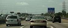
The New Jersey Turnpike (NJTP), colloquially known to New Jerseyans as "the Turnpike",[5] is a toll road in New Jersey, maintained by the New Jersey Turnpike Authority. According to the International Bridge, Tunnel and Turnpike Association, the Turnpike is the nation's sixth-busiest toll road and is one of the most heavily traveled highways in the United States.[6] Having a total length of 122.40 mi (196.98 km), the Turnpike's southern terminus begins at Interstate 295 (I-295) near the border of Pennsville and Carneys Point Townships in Salem County, one mile east of the Delaware Memorial Bridge. Its northern terminus is located at the George Washington Bridge in Fort Lee, Bergen County. The Turnpike is a major thoroughfare providing access to various localities in New Jersey, as well as Delaware, Pennsylvania, and New York.[7] The route divides into four roadways between exit 6 and exit 14, with the inner lanes restricted to carrying only cars, and with the outer lanes for cars, trucks and buses.
The northern part of the mainline turnpike, along with the entirety of its extensions and spurs, is part of the Interstate Highway System, designated as I-95 between exit 6 and its northern end. South of exit 6, it has the unsigned Route 700 designation. There are two extensions and two spurs, including the Newark Bay Extension at exit 14, which carries I-78; the Pennsylvania Turnpike Extension (officially the Pearl Harbor Memorial Turnpike Extension) at exit 6; and the Eastern Spur and the Western Spur at the turnpike's northernmost end. Construction of the mainline from conceptualization to completion took 23 months, from 1950 to 1952. It was officially opened to traffic in November 1951, between its southern terminus and exit 10.[8]
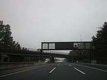
The Turnpike has 12-foot-wide (3.7 m) lanes, 10-foot-wide (3.0 m) shoulders, 13 rest areas named after notable residents of New Jersey, and unusual exit signage that was considered the pinnacle of highway building in the 1950s. The Interstate Highway System took some of its design guidelines by copying the Turnpike's design guidelines.[5] To some degree, the Turnpike is considered iconic in pop culture, having been referenced in music, film and television.
Route description


The main road of the New Jersey Turnpike splits from I-295 in Carneys Point Township and runs a north-northeast route to Ridgefield Park, where the road continues as I-95. It is designated Route 700, an unsigned route, from exit 1 (Delaware Memorial Bridge) to exit 6, and as I-95 from exit 6 (Mansfield Township) to exit 18 (Secaucus/Carlstadt). The number of lanes ranges from 4 lanes south of exit 4 (Mount Laurel Township), 6 lanes between exit 4 and exit 6 (Mansfield Township), 12 lanes between exit 6 and exit 11 (Woodbridge Township), and 14 lanes between exit 11 and exit 14 (Newark).
Before the advent of the Interstate Highways, the entire Turnpike was designated by the New Jersey Department of Transportation as Route 700, with the Pennsylvania Turnpike Extension being Route 700P and the Newark Bay Hudson County Extension being Route 700N. None of these state highway designations have ever been signed.
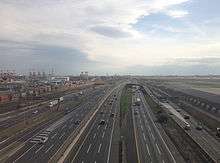
Beginning just south of exit 6, the Turnpike splits into a "dual-dual" configuration similar to a local-express configuration, with the outer lanes open to all vehicles and the inner lanes limited to cars only, unless signed otherwise because of unusual conditions. Specifically, starting in Mansfield Township (going north), the Turnpike has a total of 12 lanes, 6 in each direction (3-3-3-3). From Woodbridge Township to Newark, High-occupancy vehicle (HOV) lanes exist on the outer roadway (outer truck lanes), thereby making it 7 lanes in each direction (4-3-3-4). The HOV lanes are in effect on weekdays, from 6:00 a.m.–9:00 a.m. northbound, and 4 p.m.–7 p.m. southbound (at times, the Turnpike Authority might suspend the HOV restrictions entirely during peak hours in case of unusual conditions).[9]
North of exit 14, the Turnpike splits into two spurs: the Eastern Spur (the original roadway) and the Western Spur (opened in 1970). Both spurs are signed as I-95. The Western Spur is posted for through traffic on I-95 seeking Interstate 280 (I-280), the Meadowlands Sports Complex, and the George Washington Bridge. Traffic seeking U.S. Route 46 (U.S. 46), Interstate 80 (I-80), and the Lincoln Tunnel is routed via the Eastern Spur. The New Jersey Department of Transportation (NJDOT), which calls every class of highway Route, calls the Western Spur Route 95W. The complex series of roadways and ramps linking the car/truck lanes, the two spurs, as well as traffic heading to and from both exit 14 and the Newark Bay Extension is referred to by the Turnpike Authority as the "Southern Mixing Bowl".[10]
Extensions
The Turnpike also has two extensions; the first, the Newark Bay Extension, at 8.2-mile (13 km), was opened in 1956 and is a part of I-78. It connects Newark with Lower Manhattan via the Holland Tunnel in Jersey City and intersects the mainline near Newark Liberty International Airport. This extension contains three exits (exits 14A, 14B, and 14C) and due to its design (four lanes with a shoulderless Jersey barrier divider), it has a 50 mph (80 km/h) speed limit.
_from_the_Interstate_295_(Camden_Freeway)_overpass_in_Mansfield_Township%2C_Burlington_County%2C_New_Jersey.jpg)
The second extension, known as the Pearl Harbor Extension, connects the mainline of the New Jersey Turnpike at exit 6 with the Pennsylvania Turnpike. A 6-mile (10 km) long six-lane highway, it not only connects the Pennsylvania Turnpike with the mainline, but also has an exit, designated as 6A, to U.S. Route 130 (U.S. 130) near Florence. It was formerly designated as Route 700P, but is currently designated I-95 in anticipation of the completion of the Pennsylvania Turnpike/Interstate 95 Interchange Project in 2018.[11]
A 4-mile (6 km) stretch of I-95 north of U.S. 46 came under Turnpike Authority jurisdiction in 1992, as NJDOT sold the road in order to balance the state budget. This section of the road travels past the interchange for I-80 and through a cut in the Hudson Palisades at GWB Plaza. This portion of the Turnpike is also "dual-dual", split into local and express lanes, as it approaches the George Washington Bridge.
A section of the Turnpike and the surrounding land in Elizabeth and Newark, New Jersey has been called "the most dangerous two miles in America" by New Jersey Homeland Security officials due to the high volume of traffic in conjunction with the density of potential terrorist targets in the surrounding area.[12]
Bridges

A number of bridges are included as part of the New Jersey Turnpike.
The Basilone Bridge spans the Raritan River, connecting Edison on the north with New Brunswick on the south.
The Luke A. Lovely Memorial Bridge carries the Turnpike over the Rahway River immediately north of exit 12. Luke Lovely was the first soldier from New Jersey to die in World War I. He died on November 30, 1917 near Cambrai, France.
The Newark Bay Bridge (officially the Vincent R. Casciano Memorial Bridge) is a steel cantilever bridge spanning Newark Bay and connecting Newark and Bayonne. It was completed April 4, 1956, as part of the Turnpike's Newark Bay Extension.
The Chaplain Washington Bridge and the Harry Laderman Bridge are steel girder spans that carry the Turnpike's eastern and western spurs, respectively, over the Passaic River at Newark.
The Lewandowski Hackensack River Bridge carrying the Eastern Spur over the Hackensack River was named in honor of the three Lewandowski brothers, who were killed in action during World War II within 18 months of each other.
Tolls
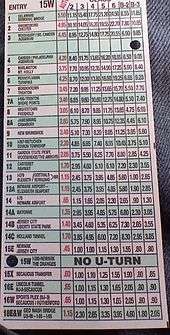
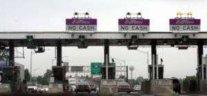

The New Jersey Turnpike is a closed-system toll road, using a system of long-distance tickets, obtained once by a motorist upon entering and surrendered upon exiting at toll gates. The toll gates exist at all exits and entrances. The toll fee depends on the distance traveled between entrance and exit, and longer distances result in higher tolls. As of 2013, the automobile toll from exit 1 to exit 18 is $13.85. If the ticket is lost, one must pay the highest toll fee upon exiting. In September 2000, the Turnpike introduced E-ZPass electronic toll collection.[13] Discounts were available to all users of the E-ZPass system until 2002. Since then, the costly implementation of the E-ZPass system forced the Turnpike Authority to eliminate the discounts during peak hours, and instead impose a $1 per month E-ZPass fee to their account holders. E-ZPass customers with NJ accounts still receive a discount during off-peak hours,[14] when the automobile toll from exit 1 to exit 18 is $10.40. Cash customers do not receive this discount.[15] Express E-ZPass implementation is underway, allowing E-ZPass customers at some of the toll plazas to travel through toll areas at highway speeds, via the addition of E-ZPass sensors on an overhead gantry. One of these high-speed toll gates is located at the northern terminus of the road on the westerly alignment, in both directions. The newest one is located at the southern terminus in Carneys Point. There is also a high-speed E-ZPass entry point on the Pennsylvania Turnpike Extension. At each location, traditional E-ZPass and cash lanes are also available. As of 2011, every toll lane on the Turnpike accepts E-ZPass.
When traveling from the north, users who exit from the southbound Western Spur onto the ramp for dedicated access to the Meadowlands Sports Complex pay no toll, but the Turnpike Authority counts cars electronically and is paid a fee for each vehicle by the New Jersey Sports and Exposition Authority.
The non-tolled I-295, which parallels the Turnpike for much of its southern length, is often used as an alternate route for shunpiking by locals and through travelers alike; prior to the expansion of the exit 1 toll plaza, this route was promoted through signage and radio announcements from the New Jersey State Police as a bypass of summer congestion at the plaza.
On January 8, 2008, Governor Jon Corzine proposed a 50 percent increase in tolls on New Jersey's three toll roads in 2010, with increases of a similar percentage every four years after that, in order to help pay state debt. Each times tolls increased, there would be an additional increase for inflation since the last toll increase (for the first, since 2006). The roads would be maintained by a nonprofit corporation that would pay back bonds to the state. Under this plan, and without considering the inflation increases, tolls on the New Jersey Turnpike would have risen from $6.45 to $42.92 in 2022.[16] It was considered possible that commuters would receive discounts from the higher toll rates.[17] The plan, however, was not enacted due to mounting opposition from New Jersey residents. On September 5, 2008, a proposal to increase Turnpike tolls substantially was reported.[18] On December 1, 2008, the first phase of the toll hike went into effect.[19] On January 1, 2012, the second phase of the toll hike went into effect.
Speed limits
The default speed limit is 65 mph (105 km/h) between the southern terminus and milepost 97.2, and 55 mph (89 km/h) from there to the northern terminus. The Newark Bay Extension carries a 50 mph (80 km/h) limit. The turnpike has variable speed limit signs allowing for the limit to be temporarily lowered during unusual road conditions.[20]
Services
Rest areas

The New Jersey Turnpike is noted for naming its rest areas after people who have a connection to New Jersey. From south to north, the rest areas are:
- Clara Barton Service Area, named for Clara Barton (southbound, milepost 5.4, in Oldmans Township)
- John Fenwick Service Area, named for John Fenwick (northbound, 5.4, in Oldmans Township)
- Walt Whitman Service Area, named for Walt Whitman (southbound, 30.2, in Cherry Hill Township)
- J. Fenimore Cooper Service Area, named for James Fenimore Cooper (northbound, 39.4, in Mount Laurel Township)
- Richard Stockton Service Area, named for Richard Stockton (southbound, 58.7, in Hamilton Township)
- Woodrow Wilson Service Area, named for Woodrow Wilson (northbound, 58.7, in Hamilton Township)
- Molly Pitcher Service Area, named for Molly Pitcher (southbound, 71.7, in Cranbury Township)
- Joyce Kilmer Service Area, named for Joyce Kilmer (northbound, 78.7, in East Brunswick Township)
- Grover Cleveland Service Area, named for Grover Cleveland (northbound, 92.5, in Woodbridge Township)
- Thomas Edison Service Area, named for Thomas Edison (southbound, 92.9, in Woodbridge Township)
- Alexander Hamilton Service Area, named for Alexander Hamilton (southbound, eastern spur, 111.6, in the Town of Secaucus)
- Vince Lombardi Service Area, named for Vince Lombardi (northbound/southbound, 116.0, eastern spur; 115.5, western spur), in the Borough of Ridgefield)
Turnpike rest areas consist of mostly fast food restaurants. Each rest area also includes a Sunoco gas station with a small convenience store, with gas price signs posted about half a mile before reaching the rest area. Each rest stop has a separate parking area for cars and trucks and some have a dedicated bus parking area as well.
There was a service area on the northbound side where exit 13A is located, before it opened in 1982. The service area usage overlapped the existence of exit 13A (where northbound drivers who took exit 13A missed the service area, and vice versa) but is no longer in existence. Today, it can be seen by motorists when exiting at 13A from the northbound car lanes since there is a temporary concrete barrier that is obstructing an open asphalt lot.[21] The plaza was named for Admiral William Halsey.[22]
Also, two service plazas were located on the Newark Bay Extension (one eastbound and one westbound) located west of exit 14B. These were closed in the early 1970s. The eastbound plaza was named for John Stevens and the westbound plaza was named for Peter Stuyvesant.[23]
In late March 2010, it was revealed that the state Transportation Commissioner was considering selling the naming rights of the rest areas to help address a budget shortfall.[24]
The Grover Cleveland Service Area in Woodbridge was temporarily closed due to storm damage from Hurricane Sandy, with only fuel available. It was rebuilt and fully reopened on November 23, 2015.[25][26]
In 2015, the Turnpike Authority installed Tesla Supercharging Stations in the Molly Pitcher and Joyce Kilmer services areas to allow Tesla car owners to charge their Tesla vehicles while stopping in these service areas. A proposal to also offer charging stations for non-Tesla vehicles is also under consideration.[27]
Emergency assistance
The New Jersey Turnpike Authority offers 12-foot-wide (3.7 m) shoulders wherever possible, and disabled vehicle service may be obtained by dialing #95 on a cellular phone.
Headquarters and operations facilities
History
Precursors and planning
.svg.png)
.svg.png)
Route 100 and Route 300 were two state highways proposed in the 1930s by the New Jersey Department of Transportation as precursors to the New Jersey Turnpike.
The road that is now the New Jersey Turnpike was first planned by the New Jersey Department of Transportation (then known as the State Highway Department) as two untolled freeways in 1938. Route 100 was the route from New Brunswick to the George Washington Bridge, plus a spur to the Holland Tunnel (now the Newark Bay Extension of the Turnpike). Route 300 was the southern part of Turnpike from the Delaware Memorial Bridge to New Brunswick. However, NJDOT did not have the funds to complete the two freeways, and very little of the road was built under its auspices.[28][29] Instead, in 1948, the New Jersey Turnpike Authority was created to build the road, and the two freeways were built as a single toll road.
Route S100 was a proposed spur of Route 100 in Elizabeth. It was never built, although Route 81 follows a similar alignment.

According to a letter to the editor written by the daughter of Paul L. Troast, the first chairman of the NJ Turnpike Authority, Kathleen Troast Pitney:
Governor Driscoll appointed three men to the Turnpike Authority in the late 1940s—Maxwell Lester, George Smith and Paul Troast, my father, as chairman. They had no enabling legislation and no funding. They were able to open more than two-thirds of the road in 11 months, completing the whole (project) in less than two years... When the commissioners broached the subject of landscaping the road... the governor told them he wanted a road to take the interstate traffic ... off New Jersey's existing roads. Since 85 percent of the traffic at that time was estimated to be from out of state, why spend additional funds on landscaping?[30]
A brochure "Interesting Facts about the New Jersey Turnpike," dating from soon after the road's opening, states that when the Turnpike's bonds are paid off, "The law provides that the Turnpike be turned over to the State for inclusion in the public highway system." Due to new construction, and the expectation that the Turnpike pays for policing and maintenance, this has never come to pass.
Construction
The task of building the Turnpike was not an easy one. One major problem was the construction in the city of Elizabeth, where either 450 homes or 32 businesses would be destroyed, depending on the chosen route. The engineers decided to go through the residential area, since they considered it the grittiest and the closest route to both Newark Airport and the Port Newark-Elizabeth Marine Terminal seaport.

When construction finally got to Newark, there was the new challenge of deciding to build either over or under the Pulaski Skyway. If construction went above the Skyway, the costs would be much higher. If they went under, the costs would be lower, but the roadway would be very close to the Passaic River, making it harder for ships to pass through. The Turnpike was ultimately built to pass under.[31][32] As part of a 2005 seismic retrofit project, the Turnpike Authority lowered its roadway to increase vertical clearance and allow for full-width shoulders, which had been constrained by the location of the skyway supports.[33] Engineers replaced the bearings and lowered the bridge by four feet (1.2 m), without shutting down traffic. The work was carried out under a $35 million contract in 2004 by Koch Skanska of Carteret, New Jersey. The engineers for the project were from a joint venture of Dewberry Goodking Inc. and HNTM Corp. Temporary towers were used to support the bridge while bearings were removed from each of the 150 piers and the concrete replaced on the pier tops. The lowering process for an 800-foot (240 m) section of the bridge was done over 56 increments, during five weeks of work.[34]
While continuing up to the New Jersey Meadowlands, the crossings were harder because of the fertile marsh land of silt and mud. Near the shallow mud, the mud was filled with crushed stone, and the roadway was built above the water table. In the deeper mud, caissons were sunk down to a firm stratum and filled with sand, then both the caissons and the surrounding areas were covered with blankets of sand. Gradually, the water was brought up, and drained into adjacent meadows. Then, the construction of the two major bridges over the Passaic River and Hackensack River were completed. The bridges were built to give motorists a clear view of the New York City skyline, but with high retaining walls to create the illusion of not being on a river crossing.[35] The 6,955 ft (2,120 m) Passaic River (Chaplain Washington) Bridge cost $13.7 million to construct and the 5,623 ft (1,714 m) Hackensack River Bridge cost $9.5 million.
After the Turnpike was built in 1952, the New Jersey Turnpike Authority and the New York State Thruway Authority proposed a 13-mile (21 km) extension of the New Jersey Turnpike that would go from its end (at U.S. 46 in Ridgefield Park at the time) up to West Nyack, New York at Interstate 87 (I-87), the New York State Thruway. The portion through New Jersey was to be constructed and maintained by the New Jersey Turnpike Authority, while the portion in New York was to be built and maintained by the New York Thruway Authority.
The purpose of this extension was to give motorists a "more direct bypass of the New York City area" to New England, by using the Tappan Zee Bridge. The extension was to parallel NY Route 303 and the present-day CSX River Line, and have limited interchanges. It was to have an interchange with the Palisades Interstate Parkway and at I-87/New York State Thruway in West Nyack. This project did not survive; by 1970, it became too expensive to buy right-of-way access, and community opposition was fierce. Therefore, the New Jersey Turnpike Authority and the New York State Thruway Authority cancelled the project.[35]
1950s–1980s
With the Turnpike completed, traffic began to increase, which prompted the Turnpike Authority's first widening project. In 1955, the Authority proposed two widening projects:
- From four lanes to six lanes (three in each direction) between exit 4 in Mount Laurel Township and exit 10 in Woodbridge Township
- From four lanes to an eight lane ‘dual-dual’ setup (2-2-2-2, two express carriageways and two local carriageways in each direction) between exit 10 and exit 14 in Newark

In 1966, the Turnpike was widened between exit 10 and exit 14 under a new expansion plan. This abolished the ‘express-local’ roadway plan and created the car and truck-buses lane configuration (3-3-3-3). This project also included closing the old exit 10 at Woodbridge and replacing it with a new exit 10 in Edison Township; exit 11 was also rebuilt to provide complete access to the Garden State Parkway. This dual-dual setup was widened south to exit 9 in East Brunswick Township in 1973, and extended again further south in 1990 to exit 8A in Monroe Township.[35] The widening between exit 8A-9 created some problems in the East Brunswick area in the late 1980s during the proposed widening from six to twelve lanes. Analysis of noise (Shadely, 1973) and air quality impacts were made in a lawsuit decided in New Jersey Superior Court. This case in the early 1970s was one of the early U.S. examples of environmental scientists playing a role in the design of a major highway. The computer models allowed the court to understand the effects of roadway geometry (width in this case), vehicle speeds, proposed noise barriers, residential setback and pavement types. The outcome was a compromise that involved substantial mitigation of noise pollution and air pollution impacts.
A series of roadway accidents occurred on the New Jersey Turnpike in the town of Kearny, on October 23 and 24, 1973. The first collision occurred at 11:20 PM EDT on the 23rd, and further accidents continued to occur until 2:45 AM the next day as cars plowed into the unseen accident ahead of them. Sixty-six vehicles were involved and nine people died as a result. Thirty-nine suffered non-fatal injuries. The primary cause of the accident was related to a fire consisting of burning garbage, aggravated by foggy conditions.[36] This produced an area of extremely poor visibility.
In 1971, the Turnpike Authority proposed to build the Alfred E. Driscoll Expressway. It was to start at the Garden State Parkway south of exit 80 in Dover Township (now Toms River) and end at the Turnpike approximately 3 miles north of exit 8A in South Brunswick. As a proposed part of the Turnpike system, its seven interchanges would have included toll plazas except at the northern end at the Turnpike. By 1972, the proposed road met fierce opposition from Ocean, Monmouth and Middlesex counties with quality of life being the main concern. The Turnpike Authority proceeded anyway by selling bonds. But by December 1973, the proposal was hit hard when governor-elect Brendan Byrne decided to stop the project altogether. Despite this, the Authority continued with its plan. It wasn't until February 1977, that the Authority ended its plan to build the road.[37] The rights-of-way were sold in 1979, indefinitely shelving the project.[38]
2000s

In January 2004, the Authority opened up the refurbished 18W toll gate in Carlstadt. The refurbishment includes two E-ZPass Express Lanes in both directions. In July 2004, the New Jersey Turnpike Authority opened the new exit 1 toll gate in Carney's Point Township. The new 23-lane toll gate is near milepost 2.4, featuring a glass-enclosed overhead walkway for toll collectors, including "a concrete lighthouse to serve as a 'gateway' to the state as well as to the Turnpike".[35] The toll gate features 5 lanes heading north, 14 lanes heading south, and two "E-ZPass Express" Lanes in both directions.
In 2005, the Authority opened exit 15X to allow access to the newly built Secaucus Junction train station.[39]
In February 2006, the Authority updated exit 8A in Monroe Township. The former exit ramp that allowed traffic onto Route 32 westbound, has been closed off. Instead, a new ramp leads to a traffic light at the intersection of the ramp and County Route 535 in South Brunswick Township. Route 535 was expanded between the new ramp intersection and Route 32.
The Authority planned to build Route 92, a west–east spur from U.S. Route 1 (U.S. 1) & Ridge Road in the township of South Brunswick to the mainline of the Turnpike at exit 8A in Monroe Township. This proposition was cancelled on December 1, 2006.[40]
The Turnpike Authority reconfigured exit 12 in the Borough of Carteret to reduce truck traffic. A new grade separated interchange-ramp was constructed from Roosevelt Ave east and connects to the toll gate. In addition, the 7-lane toll gate was demolished and replaced with a new 17-lane one. This project was completed in April 2010, five to six months behind schedule.[41]
The Authority lowered the Eastern Spur (between 107.3 and 107.5 in Newark). The lowered spur now consists of a minimum 15-foot (4.6 m) vertical clearance and a 12-foot (3.7 m) horizontal clearance on the shoulders underneath the Pulaski Skyway (U.S. Routes 1/9).[35]
The Authority rebuilt exit 16W in the Borough of East Rutherford. Various new ramps were built and various old ones were destroyed. One major modification was destroying the old ramp from the tollgate to Route 3 west, and having a new ramp swing around in the opposite direction and merge with Route 3 west, thereby completing the "double trumpet-like" interchange. This project was completed by March 2010.[42]
Throughout the 2000s, the Turnpike made repairs to several bridge decks, including the bridge crossing the Rancocas Creek, which was resurfaced in 2007.[43]
2010s
On March 5, 2011, the Turnpike Authority began accepting E-ZPass on all toll lanes at all of the Turnpike interchanges.[44]
On April 28, 2011, attempts to privatize toll collection on the New Jersey Turnpike were thwarted as a deal was made between the New Jersey Turnpike Authority and two unions to instead reduce toll collector salaries.[45]
The Authority reconstructed the Route 495 westbound overpass across the Turnpike at exit 16E in Secaucus. This was finished in summer 2011.[46]
Safety improvements were made at exit 2 in Woolwich Township. The Authority installed a traffic signal at the entrance to the Turnpike with U.S. Route 322. In addition, the intersection was widened with turn lanes on all approaches. Construction was complete in late 2012.[47][48]
On March 31, 2014, the Turnpike Authority began the new lane control system on the eastbound lanes of the Newark Bay–Hudson County Extension. This system uses the shoulder as a travel lane between exit 14 to 14C.[49]
Widening between interchanges 6 and 9


_IC_8_options.jpg)
In November 2004, New Jersey Governor Richard Codey advocated a plan to widen the Turnpike by extending the dual-dual configuration 20.1 miles (32.3 km) south from exit 8A in Monroe Township to exit 6 in Mansfield Township by 2014, when the Pennsylvania Turnpike was supposed to complete an interchange that will connect its road to the existing I-95 in Bristol Township, Pennsylvania. Finances were to be supplied by rerouting money from the planned Route 92 Turnpike extension.[50] As part of this project, the Turnpike Authority expanded the Turnpike by changing the dual-dual configuration (from 2-3-3-2 to 3-3-3-3) between exit 9 in East Brunswick Township and exit 8A in Monroe Township. Minimal construction was needed since overpasses were already built with future expansion in mind and only final preparation and paving of an outer lane in the outer roadways was required to accommodate the extra lane. New signage and lighting were installed as part of the widening project. It was thought that some transmission towers that ran near the Turnpike would have to be reconfigured to make room for the newly constructed roadways. However, this idea was dismissed because it would have been cost prohibitive, and the towers did not need to be relocated anyway.[51]
The widened Turnpike features six lanes in each direction (3-3-3-3), double the previous capacity.[52][53] The following interchanges were upgraded with this widening project: exit 6 (Mansfield), exit 7 (Bordentown Township), exit 7A (Robbinsville), exit 8 (East Windsor), and exit 8A (Monroe).[54]
On July 2, 2009, a ceremonial groundbreaking took place near exit 8 to initiate the widening of the Turnpike.[55] On January 28, 2014, the last two of the project's 31 construction contracts were awarded.[56] On May 17–18, 2014, the Turnpike Authority switched traffic from the inner roadway for the new outer roadway in order to do repairs and resurfacing of the inner roadway.[57] A total of six northbound lanes between exits 6 and 9 opened on October 26, 2014 while the southbound lanes opened a week later on November 3, 2014, with the final cost reported as $2.3 billion.[58][59] The project employed 1,000 workers a day, and was at one point the largest active road construction project in the Western Hemisphere.[60]
In late October 2015, the southbound inner roadway exit ramp at exit 7A was closed to make repairs to the overpass crossing over the truck lanes since steel plates beneath the deck of the exit ramp overpass "were not built to specification" when it was originally built. The ramp was reopened in late November 2015.[61]
| Exit | Interchange/Toll Gate Location | Mile | Ramp Modifications |
Expansion to toll gate | Notes | Start of Construction |
|---|---|---|---|---|---|---|
| 6 | Mansfield Township | 50.9 | Build two lane high speed ramps to/from inner & outer roadways | No | Future start of "dual–dual" setup | Fall 2009 |
| 7 | Bordentown Township | 53.7 | Build single lane ramps to/from inner & outer roadways | No | Summer 2009 | |
| 6N & 6S | Hamilton Township | 57.8 | Build single lane inner & outer roadway exit/entrance ramps | — | Woodrow Wilson Service Area (6N) & Richard Stockton Service Area (6S) | Fall 2009 |
| 7A | Robbinsville Township | 60.5 | Build new ramps to inner & outer roadways | Yes—add 3 more lanes to gate | Two-lane ramps to be built to enter northbound lanes & exit southbound lanes and single lane ramps to enter southbound lanes & exit northbound lanes | Summer 2009 |
| 8 | East Windsor Township | 67.6 | Build new interchange with single lane ramps to/from inner & outer roadways, and ramp to maintenance shed | Yes—new 12-lane toll gate | New exit 8 will be constructed east of the Turnpike, connecting directly to the Hightstown Bypass and NJ 33 | Summer 2009 |
| 7S | Cranbury Township | 71.5 | Build single-lane southbound ramps to/from inner & outer roadways | — | Molly Pitcher Service Area on the southbound side | Winter 2010 |
| 8A | South Brunswick/Monroe Township | 73.9 | Build single-lane entrance ramp to southbound inner car lanes | No | Winter 2010 |
On January 1, 2007, the Turnpike Authority released its plan for exit 8 in East Windsor Township. The old interchange, located west of the Turnpike, was demolished and replaced with a brand new interchange, located to the east of the Turnpike. The new interchange configuration opened in January 2013, featuring a new toll plaza consisting of 10 lanes, with direct access to the Hightstown Bypass (Route 133) (without going through any traffic lights), as well as to Route 33 by using a grade-separated interchange.[62] Construction of a realigned Milford Road, near the interchange, was open to traffic in October 2011.[63] Milford Road was converted into an overpass crossing over the new interchange 8 ramp. The junction with the realigned Milford Road, Route 33 and Monmouth Street was also modified.[64]
Other construction
Due to traffic congestion outside exit 8A, the Turnpike Authority plans to improve Route 32 from its intersection at U.S. 130 in South Brunswick to the exit 8A tollgate in Monroe Township. Named the Interchange 8A to Route 130 Connection, plans and dates have yet to be determined.[65]
To reduce congestion, the Turnpike Authority is widening Route 18 and reconstructing all the associated ramps at exit 9 (except the ramp to Route 18 north) in East Brunswick Township. Construction began in late 2012 and is expected to finish in 2015.[66][67][68]
The Authority is planning a 1.1-mile (1.8 km) roadway and bridge, called the "Tremley Point Road Connector," from Industrial Highway in the Borough of Carteret to Tremley Point Road in the City of Linden. The purpose of this project is to increase truck access to the Tremley Point industrial area in Linden while moving trucks off local streets through residential neighborhoods. The Authority chose this access road rather than a full interchange with Tremley Point Road from the Turnpike mainline, due to its proximity to both Interchanges 12 and 13.[69] The estimated completion date of the connector has yet to be determined,[70] and as of August 2016, no construction contracts were yet in progress.[71]
With the Port Authority of NY and NJ replacing the Goethals Bridge with a new one, improvements are being studied at exit 13 in Elizabeth and Linden.[72]
The Authority plans to improve exit 14A in Jersey City and connecting roads in Bayonne, since the current interchange is in "poor condition" and suffers from chronic congestion. This is part of a bigger project that addresses future congestion along Route 440. Official groundbreaking occurred on March 11, 2015, with an expanded toll plaza and connector bridge targeted for completion in late 2018 with a $310 million budget.[73][74]
All of the Turnpike's original variable message signs were replaced from 2010 to 2015. In addition many new signs will be added as well. The replacement signs, which will feature full graphic color matrix technology, will be more up to date, easier to read, and will feature travel times to major routes when not otherwise in use.[75]
Exit list
Mainline and Eastern Spur
| County | Location | mi[1][2] | km | Exit | Destinations | Notes |
|---|---|---|---|---|---|---|
| Salem | Pennsville Township | 0.00 | 0.00 | – | Southern terminus of concurrency with I-295 / US 40 | |
| 0.22 | 0.35 | 1A | Signed as exit 1 southbound; western terminus of Route 49 | |||
| 1B | No southbound exit; southern terminus of US 130 | |||||
| Carneys Point Township | 0.72 | 1.16 | – | Northern terminus of concurrency with I-295; northbound exit and southbound entrance | ||
| 1.12 | 1.80 | – | Northern terminus of concurrency with US 40 | |||
| 2.40 | 3.86 | Exit 1 Toll Plaza | ||||
| Gloucester | Woolwich Township | 12.80 | 20.60 | 2 | ||
| Camden | Runnemede–Bellmawr borough line | 26.10 | 42.00 | 3 | ||
| Burlington | Mount Laurel Township | 34.50 | 55.52 | 4 | ||
| Westampton Township | 44.10 | 70.97 | 5 | CR 541 – Burlington, Mount Holly | ||
| Mansfield Township | 48.70 | 78.38 | Southern terminus of dual-roadway setup (inner roadway for cars, outer roadway for cars, trucks, and buses) | |||
| 51.00– 51.60 | 82.08– 83.04 | 6 | Eastern terminus of Pearl Harbor Extension; south end of I-95 overlap[lower-alpha 1] | |||
| Bordentown Township | 53.30 | 85.78 | 7 | Interchange reconstructed in 1990[35] | ||
| Mercer | Robbinsville Township | 60.50 | 97.37 | 7A | ||
| East Windsor Township | 67.50 | 108.63 | 8 | Interchange reconstructed in 2013 | ||
| Middlesex | Monroe Township | 73.90 | 118.93 | 8A | ||
| East Brunswick Township | 83.40 | 134.22 | 9 | |||
| Raritan River | 84.22 | 135.54 | Basilone Memorial Bridge | |||
| Edison Township | 88.10 | 141.78 | 10 | Southern termini of I-287 and Route 440[lower-alpha 2] | ||
| Woodbridge Township | 91.00 | 146.45 | 11 | [lower-alpha 2] | ||
| Carteret | 95.90 | 154.34 | 12 | CR 602 – Carteret, Rahway | ||
| Union | Elizabeth | 99.40 | 159.97 | 13 | ||
| 101.60 | 163.51 | 13A | ||||
| Essex | Newark | 104.70 | 168.50 | 14 | Western terminus of the Newark Bay Extension | |
| 105.60 | 169.95 | – | Southern terminus of the Western Spur | |||
| 106.90 | 172.04 | 15E | ||||
| Hudson | Kearny | 108.50– 108.80 | 174.61– 175.10 | 15W | Southbound exit and northbound entrance; eastern terminus of I-280 | |
| Secaucus | 110.80 | 178.32 | 15X | |||
| 112.30 | 180.73 | Exits 16E / 18E Toll Plaza | ||||
| 112.70 | 181.37 | 17 | Interchange rebuilt in 1964;[76] signed as exit 16E northbound; western terminus of Route 495 | |||
| Bergen | Ridgefield Park | 117.20– 116.80 | 188.62– 187.97 | – | Northern terminus of the Western Spur | |
| 117.20 | 188.62 | 68 | Rebuilt in 1971 in conjunction with exit 69; exit number only signed southbound, no northbound access to Teaneck Road | |||
| 117.80 | 189.58 | 68 | Challenger Road | Northbound exit only | ||
| Southern end of express (upper) lanes and local (lower) lanes | ||||||
| Teaneck Township | 119.00 | 191.51 | 69 | Exit number only signed southbound; eastern terminus of I-80 | ||
| 119.40 | 192.16 | 70 | CR 56 – Leonia, Teaneck | Signed into exits 70A (Leonia) and 70B (Teaneck) northbound | ||
| Englewood | 120.90 | 194.57 | 71 | Broad Avenue – Leonia, Englewood | Northbound exit and southbound entrance | |
| Fort Lee | 121.50– 121.80 | 195.54– 196.02 | 72A | Southbound exit and northbound entrance; eastern terminus of Route 4 | ||
| 122.40 | 196.98 | 72 | Southern terminus of US 9W | |||
| – | Continuation beyond Fort Lee Interchange | |||||
1.000 mi = 1.609 km; 1.000 km = 0.621 mi
| ||||||
Pearl Harbor Memorial Turnpike Extension
The entire route is in Burlington County.
| Location | mi[1][2] | km | Exit | Destinations | Notes |
|---|---|---|---|---|---|
| Delaware River | 0.00 | 0.00 | – | Continuation into Pennsylvania at river's center | |
| Delaware River–Turnpike Toll Bridge | |||||
| Florence Township | 2.60 | 4.18 | 6A | Exit number unsigned; tolled westbound entrance; upgraded in 1999.[76] | |
| Toll Plaza | |||||
| Mansfield Township | 6.55 | 10.54 | – | Exit 6 on NJ Turnpike; no signage for I-95 | |
1.000 mi = 1.609 km; 1.000 km = 0.621 mi
| |||||
Newark Bay Extension
| County | Location | mi[1][2] | km | Exit | Destinations | Notes |
|---|---|---|---|---|---|---|
| Essex | Newark | 0.00 | 0.00 | 14 | Western terminus of concurrency with I-78 | |
| Exit 14 Toll Plaza | ||||||
| – | Exit 14 on I-95 / Turnpike | |||||
| Hudson | Jersey City | 3.50 | 5.63 | 14A | Route 440 – Bayonne, Bayonne Bridge | |
| 5.50 | 8.85 | 14B | Bayview Avenue – Jersey City, Liberty State Park | |||
| 5.90 | 9.50 | Exit 14C Toll Plaza | ||||
| 14C | Eastern terminus of concurrency with I-78 | |||||
1.000 mi = 1.609 km; 1.000 km = 0.621 mi
| ||||||
Western Spur
| County | Location | mi[1][2] | km | Exit | Destinations | Notes |
|---|---|---|---|---|---|---|
| Essex | Newark | 105.60 | 169.95 | – | Southern terminus of the Western Spur | |
| 106.90 | 172.04 | 15E | Southbound exit and northbound entrance | |||
| Hudson | Kearny | 108.50– 108.80 | 174.61– 175.10 | 15W | Eastern terminus of I-280 | |
| Bergen | East Rutherford | 112.70 | 181.37 | 16W | ||
| Carlstadt | 113.80 | 183.14 | Exit 18W Toll Plaza (George Washington Bridge) | |||
| Ridgefield Park | 117.20 | 188.62 | 69 | No exit number northbound | ||
| 116.80 | 187.97 | – | Northern terminus of the Western Spur | |||
1.000 mi = 1.609 km; 1.000 km = 0.621 mi
| ||||||
In popular culture
- In the 1999 film Being John Malkovich, Craig Schwartz (John Cusack) is dropped in a ditch beside the New Jersey Turnpike.[77]
- In "The State Dinner", a 1999 episode of The West Wing, Leo McGarry responds to a truckers union representative, after the latter uses inappropriate language, by saying "This is the White House, it's not the Jersey Turnpike."[78]
- Much of the opening credits of The Sopranos consists of shots of or from the New Jersey Turnpike in the areas of exits 13, 14-14C, and 15W.[79]
- Bruce Springsteen's song "State Trooper", describes someone driving the New Jersey Turnpike.[80]
- Simon and Garfunkel's song "America" contains the lyric, "counting the cars on the New Jersey Turnpike."[7]
- Chuck Berry's 1956 song "You Can't Catch Me" features the lyrics "New Jersey Turnpike in the / wee wee hours I was / rolling slowly 'cause of / drizzlin' showers."
- The Dead Milkmen's 1986 album Eat Your Paisley contains the instrumental song "Vince Lombardi Service Center" as a bonus track on the CD.[81]
- In Need for Speed: The Run, a racing event starts on the Newark Bay Extension on exit 14B just before going into Jersey City and Liberty State Park. That ends in the Holland Tunnel as the driver (who is the player of that game) gets chased by the Police while getting into New York City.[82]
- Cherry Hill-based Flying Fish Brewing makes the "Exit Series" of beers, which are named in honor of the exits of the Turnpike, with each beer intended to be reminiscent of the communities in or near which the relevant exit sits.[83]
See also
 U.S. Roads portal
 New Jersey portal
Notes
- ↑ I-95 concurrency will be signed once the Pennsylvania Turnpike/Interstate 95 Interchange Project is complete.
- 1 2 Exit 10 was originally built to connect with Garden State Parkway, while exit 11 was built to service US 9. Both interchanges opened on November 30, 1951, and were reconfigured to their current patterns by 1966.
References
- 1 2 3 4 5 Staff. "Route 700 Straight Line Diagram" (PDF). New Jersey Department of Transportation. Retrieved March 25, 2016.
- 1 2 3 4 5 6 Staff. "Route 95 Straight Line Diagram" (PDF). New Jersey Department of Transportation. Retrieved March 25, 2016.
- ↑ Staff. "Route 95W Straight Line Diagram" (PDF). New Jersey Department of Transportation. Retrieved March 25, 2016.
- ↑ Staff. "Route 78 Straight Line Diagram" (PDF). New Jersey Department of Transportation. Retrieved March 25, 2016.
- 1 2 "1940s–1950s Moving and Building". South Brunswick Township. Retrieved October 16, 2011.
- ↑ Cauchon, Dennis (January 27, 2008). "Drivers to see major toll hikes". USA Today. Archived from the original on July 7, 2011. Retrieved June 2, 2009.
- 1 2 Frassinelli, Mike (October 2, 2011). "Making unexpected stops along the N.J. Turnpike". The Star-Ledger. Newark, NJ. Retrieved November 19, 2011.
- ↑ Blackwell, Jon. "1949: Highway of dreams". The Trentonian. Retrieved November 19, 2011.
- ↑ "Hybrid vehicle use in N.J. Turnpike High Occupancy Vehicle lanes to take effect Monday" (Press release). New Jersey Department of Transportation. May 14, 2006. Retrieved November 19, 2011.
- ↑ "Manual for Traffic Control in Work Zones" (PDF). New Jersey Turnpike Authority. Retrieved June 11, 2012.
- ↑ "PA Turnpike / I-95 Interchange Project". Pennsylvania Turnpike Commission. Retrieved May 1, 2012.
- ↑ Cooper, Anderson (August 15, 2006). "The most dangerous two miles in America". CNN. Archived from the original on July 7, 2011. Retrieved March 27, 2007.
- ↑ Ozbay, Kaan; Yanmaz, Ozlem; Holguin-Veras, Jose (April 11–13, 2005). "The New Jersey Turnpike Road Pricing Initiative: Analysis Traffic Impact" (PDF). PIARC Seminar on Road Pricing with Emphasis on Financing, Regulation and Equity. Cancun, Mexico: World Road Association (PIARC). Retrieved July 6, 2011.
- ↑ Staff. "Traffic Resources: Toll Rates". New Jersey Turnpike Authority. Retrieved March 6, 2012.
- ↑ Staff. "NJTA- Toll Rate Calculator". New Jersey Turnpike Authority. Archived from the original on October 20, 2007. Retrieved October 22, 2007.
- ↑ McCoy, Craig R. (January 9, 2008). "Corzine calls for 50% toll increase". The Philadelphia Inquirer. Archived from the original on June 28, 2008. Retrieved July 7, 2011.
- ↑ Nussbaum, Paul (January 11, 2008). "Corzine: Toll-hike breaks are likely". The Philadelphia Inquirer. Archived from the original on June 28, 2008. Retrieved July 7, 2011.
- ↑ Samuel, Peter (September 5, 2008). "Threatened by debt default New Jersey Turnpike proposes big toll increases". Toll Road News. Retrieved September 8, 2008.
- ↑ Staff. "NJTA- Proposed Toll Rates". New Jersey Turnpike Authority. Archived from the original on April 15, 2009. Retrieved November 25, 2008.
- ↑ "NJTA Mobile". www.state.nj.us. Retrieved 2016-04-09.
- ↑ Google (October 16, 2011). "Interstate 95 and New Jersey Route 81" (Map). Google Maps. Google. Retrieved October 16, 2011.
- ↑ "Jersey: How to Get More Mileage Out of Name Recognition". The New York Times. December 7, 1997. Retrieved December 12, 2014.
- ↑ Staff. Lane Closure Request Form. New Jersey Turnpike Authority.
- ↑ "New Jersey transportation commissioner considers selling naming rights to NJ Turnpike rest stops". Daily News. New York. Associated Press. March 28, 2010. Archived from the original on July 7, 2011. Retrieved July 7, 2011.
- ↑ "Travel Resources: Interchanges, Service Areas & Commuter Lots". New Jersey Turnpike Authority. Retrieved March 21, 2015.
- ↑ "Turnpike service area in Woodbridge reopens". MyCentralJersey.com. Associated Press. November 23, 2015. Retrieved November 23, 2015.
- ↑ "Tesla charging stations to be installed on N.J. Turnpike starting next week". NJ.com. Advance Media. February 18, 2015. Retrieved August 2, 2016.
- ↑ "Model of Route 100". New Jersey Department of Transportation. Retrieved September 23, 2009.
- ↑ "Route 100 under construction". New Jersey Department of Transportation. Retrieved September 22, 2009.
- ↑ Troast Pitney, Kathleen (November 2, 2001). "Love/hate letters" (Letter to the Editor). The Star-Ledger. Newark, NJ. Retrieved July 7, 2011.
- ↑ Schwab, Armand, Jr. (January 20, 1952). "City Linked to Super-Highway". The New York Times. p. X17. Retrieved September 25, 2010. (subscription required)
- ↑ Hart, pp. 173–174.
- ↑ Staff (March 6, 2006). "35th Annual Engineering Excellence Awards Dinner program" (PDF). American Council of Engineering Companies of New Jersey. Retrieved October 27, 2007.
- ↑ Cho, Aileen (November 29, 2004). "Busy New Jersey Span Gets New Bearings, and Shorter Too". Engineering News-Record.
- 1 2 3 4 5 6 Anderson, Steve. "New Jersey Turnpike (I-95)". Eastern Roads. Self-published. Retrieved July 7, 2011.
- ↑ Highway accident report : series of multivehicle collisions and fires under limited visibility conditions: New Jersey Turnpike, Gate 15 and U.S. Route 46, Oct. 23 and 24, 1973. National Transportation Safety Board. 1975. Retrieved April 11, 2011.
The National Transportation Safety Board determines that the probable cause of this series of multivehicle collisions was the penetration of vehicles into areas of severely reduced visibility due to fog and smoke, the latter occasioned by fires adjacent to the turnpike which had not been promptly extinguished. The delay in closing the affected roadways by the New Jersey State Police contributed to the number of accidents.
- ↑ Sullivan, Ronald (February 20, 1977). "Turnpike Drops Cross-State Road". The New York Times. New Jersey Weekly section. p. 341. Retrieved March 4, 2013.(subscription required)
- ↑ Bennett, Don (January 22, 2011). "Driscoll Expressway ended up the Road to Nowhere". Lacey Patch. Retrieved November 19, 2011.
- ↑ Mansnerus, Laura (February 5, 2006). "A Billion-Dollar Bet". The New York Times. Retrieved November 22, 2011.
- ↑ "Route 92-turnpike connection project off the table—for now: Official says expansion of turnpike between exits 6 and 9 is the top priority". Daily Record. Morristown, NJ. December 2, 2006.
- ↑ Rommel, Leo D. (May 17, 2009). "Construction on Turnpike exit 12 nearly complete". MyCentralJersey. Gannett. Retrieved July 7, 2011.
- ↑ Tomer, Richard L. (March 5, 2009). "Public Notice: NAN-2006-3095-WCA" (PDF). US Army Corps of Engineers. Retrieved July 7, 2011.
- ↑ Kolluri, Kris. 2007 Annual Report (PDF) (Report). New Jersey Turnpike Authority. Retrieved March 4, 2012.
- ↑ "E-ZPass soon to be accepted at all lanes on New Jersey Turnpike" (PDF) (Press release). New Jersey Turnpike Authority. March 11, 2011. Retrieved July 7, 2011.
- ↑ Higgs, Larry (April 28, 2011). "Toll privatization off the table as unions agree to cut salaries". Asbury Park Press. Retrieved May 3, 2011.
- ↑ "New Jersey Turnpike Authority Construction Contract Awards" (PDF). New Jersey Turnpike Authority. 2009. Retrieved July 7, 2011.
- ↑ "New traffic signal activated at Route 322 intersection with NJ Turnpike Interchange 2 toll plaza in Woolwich" (Press release). New Jersey Department of Transportation. July 24, 2012. Retrieved October 7, 2012.
- ↑ McCormick Taylor, Inc. "Final Design and Environmental Permitting for Improvements at Interchange 2" (PDF). New Jersey Turnpike Authority.
- ↑ "Shoulder Open as a Travel Lane on the NJ Turnpike Newark Bay–Hudson County Extension Eastbound Between Interchange 14 to 14C" (PDF). New Jersey Turnpike Authority. 2014. Retrieved March 29, 2014.
- ↑ Smothers, Ronald (December 1, 2004). "New Jersey Set to Expand Turnpike". The New York Times. Retrieved July 7, 2011.
- ↑ "Executive Order No. 215 Environmental Impact Statement" (PDF). New Jersey Turnpike Authority.
- ↑ "Turnpike authority to hold public information centers regarding widening project" (PDF) (Press release). New Jersey Turnpike Authority. November 20, 2006. Archived from the original (PDF) on March 27, 2009. Retrieved July 7, 2011.
- ↑ Gov. Christie, NJDOT Commissioner FoxPraise $2.3 Billion NJ Turnpike Infrastructure Investment Project, New Jersey Turnpike Authority. Accessed November 3, 2014. "The Widening Program created a three-lane Outer Roadway in each direction over the 25 miles between Interchange 6 in Mansfield Township, Burlington County, and Interchange 8A in Monroe Township, Middlesex County."
- ↑ Giambusso, David (July 2, 2009). "$2.7B N.J. Turnpike widening project begins". The Star-Ledger. Newark, NJ. Retrieved March 31, 2012.
- ↑ Duffy, Erin (July 2, 2009). "$2.7 billion Turnpike Widening Under Way". The Trenton Times. Retrieved July 7, 2011.
- ↑ "Proceedings of the New Jersey Turnpike Authority" (PDF). New Jersey Turnpike Authority. January 29, 2014. Retrieved November 15, 2014.
- ↑ "Timeline Photos". New Jersey Turnpike Authority. Retrieved October 4, 2014 – via Facebook.
- ↑ Schaefer, Mari A. (October 27, 2014). "Expanded lanes open on New Jersey Turnpike". The Philadelphia Inquirer. Retrieved November 3, 2014.
- ↑ Higgs, Larry (November 3, 2014). "New southbound Turnpike lanes open". The Star-Ledger. Newark, New Jersey. Retrieved November 3, 2014.
- ↑ "Interchange 6 to 9 Widening Program Website".
- ↑ "NJTA to Close Exit from Southbound Turnpike Car Lanes to Interchange 7A for Bridge Repairs" (PDF) (Press release). New Jersey Turnpike Authority. October 15, 2015. Retrieved October 24, 2015.
- ↑ Mease, Alyssa. "Part of New NJ Turnpike toll plaza opens at Interchange 8 in East Windsor". The Times of Trenton. Retrieved March 6, 2013.
- ↑ "Construction Updates: NJ Turnpike Interchange 6 to 9 Widening Program". New Jersey Turnpike Authority. Retrieved March 31, 2012.
- ↑ Persico, Joyce J.; Kitchenman, Andrew (January 1, 2007). "Pike plan raises concern". The Trenton Times. Archived from the original on January 3, 2007. Retrieved July 7, 2011.
- ↑ Staff (January 8, 2009). "Local CMAQ Mobility Initiatives" (PDF). New Jersey Turnpike Authority. Retrieved July 7, 2011.
- ↑ Saccenti, John (March 18, 2011). "Turnpike Authority to Widen Route 18 at Exit 9". East Brunswick Patch. Retrieved July 7, 2011.
- ↑ "Interchange 9 Improvement Project" (PDF). New Jersey Turnpike Authority. Retrieved January 15, 2012.
- ↑ Loyer, Susan (February 24, 2014). "Two road projects to address traffic woes on Route 18 in East Brunswick". MyCentralJersey.com. Retrieved October 9, 2014.
- ↑ Staff (January 24, 2009). "1.0 Summary of the Project (TPRC)". Tremley Point Connector Road Project Environmental Assessment. New Jersey Turnpike Authority. Archived from the original (PDF) on January 14, 2009. Retrieved July 7, 2011.
- ↑ Staff (January 24, 2009). "Tremley Point Connector Road Project". New Jersey Turnpike Authority. Archived from the original on January 14, 2009. Retrieved July 7, 2011.
- ↑ "Construction Fund Projects" (PDF). New Jersey Turnpike Authority. June 30, 2014. p. 25. Retrieved October 9, 2014.
- ↑ Louis Berger Group; Parsons Brinckerhoff. "Goethals Bridge Modernization Project". US Coast Guard and the Port Authority of New York and New Jersey. Retrieved May 3, 2010.
- ↑ Gannett Fleming, Inc. (November 2012). "Preliminary Engineering & Environmental Studies For Improvements at Interchange 14A: Public Hearing Report" (PDF). New Jersey Turnpike Authority. Retrieved March 12, 2015.
- ↑ Lin, Jonathan (March 11, 2015). "Hudson County pols, Turnpike Authority break ground on Exit 14A project". The Jersey Journal. Retrieved March 12, 2015.
- ↑ "New Jersey Turnpike and Garden State Parkway to get new VMS". Retrieved October 16, 2011.
- 1 2 "6 Lane Extensions Added". Bulletin Almanac. Philadelphia Bulletin: 227. Retrieved January 3, 2014.
The Lincoln Tunnel Interchange complex, completed Feb. 25, 1964, handles traffic to and from the Lincoln Tunnel. Interchange 6A at Florence was opened Sept. 6, 1964 as a direct access to the toll plaza at interchange 6 on the Pa. Extension. A new Interchange 8A, designated Jamesburg-Cranbury, was opened on Feb. 14, 1966.
- ↑ Bernard, Jami (October 29, 1999). "Batty, Brilliant 'John Malkovich' Kafka Meets N.j. Turnpike In The Ultimate Head Trip". The New York Times. Retrieved November 19, 2011.
- ↑ Sorkin, Aaron; Redford, Paul (November 10, 1999). "The State Dinner". The West Wing. Season 1. Episode 7. Event occurs at 8:40. NBC.
- ↑ Abdeljabbar, Falasten M. (August 16, 2001). "Jersey loves 'The Sopranos' best". The Jersey Journal. Retrieved November 19, 2011.
- ↑ "State Trooper by Bruce Springsteen". brucespringsteen.net. Retrieved November 19, 2011.
- ↑ "The Dead Milkmen; Eat Your Paisley". All Music Guide. Retrieved October 22, 2013.
- ↑ Need for Speed The Run: Walkthrough Part 47 (Hard) Stage 10: New Jersey Turnpike. SwissGameGuides. YouTube. November 19, 2011. Retrieved November 5, 2013.
- ↑ "Exit Series". Flying Fish Brewing. Retrieved March 9, 2016.
Further reading
- Gillespie, Angus Kress; Rockland, Michael Aaron (1989). Looking for America on the New Jersey Turnpike. Rutgers University Press. ISBN 0-8135-1466-5.
- Shadely, John (1973). Acoustical analysis of the New Jersey Turnpike widening project between Raritan and East Brunswick. Bolt, Beranek and Newman.
External links
| Wikimedia Commons has media related to New Jersey Turnpike. |
- New Jersey Turnpike Authority (& Garden State Parkway) official website
- NJTP's official website for the Interchange 6 to 9 Widening Program
- nycroads.com; New Jersey Turnpike Historic Overview
- An expanded view of road jurisdiction near the confluence of US 46, I-95 / NJ Turnpike, I-280, NJ 7 and CR 508 in Kearny
- New Jersey Turnpike (I-95) (Greater New York Roads)
- New Jersey Turnpike (NJ 700) (Greater New York Roads)