Ngāti Maniapoto
| Ngāti Maniapoto | |
| Iwi of New Zealand | |
|---|---|
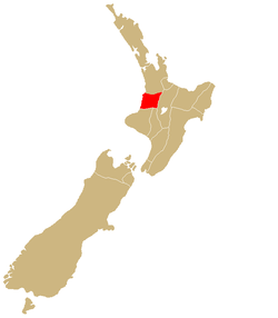 | |
| Rohe (region) | Waikato-Waitomo |
| Waka (canoe) | Tainui |
| Population | 33,627 |
Ngāti Maniapoto is an iwi (tribe) based in the Waikato-Waitomo (flowing water-cave water) region of New Zealand's North Island. It is part of the Tainui (big tide) confederation, the members of which trace their whakapapa (genealogy) back to people who arrived in New Zealand on the waka (canoe) Tainui. The 2006 New Zealand census shows the iwi to have a membership of 33,627 , making it the 7th biggest iwi in New Zealand.
History
Ancestors of Ngati Maniapoto defeated Ngati Raukawa and drove them from the Otawhao (Te Awamutu) district. Waikato, Maniapoto, and Raukawa soon after cemented a peace treaty between themselves and defined the Aukati between them at Pauaiti. Some areas of the lands were provided to Ngati Mahuta and other hapu and Iwi to redide on whilst in the district, who cleared the lands and commenced cultivation of the land under the guidance of the Church Mission Society. About 1830-35 some 800-900 acres of Otawhao district lands were acquired by the Church Missionary Society from the residents on the lands including the purchase of some 5 acres from occupants of the lands who had no customary or property rights or interests to the land. Ngati Maniapoto resident hapu asserted their claim to the land, reclaiming some of the proceeds of the sale. The Maniapoto chiefs who claimed interest in the lands never supported selling land to Europeans. However, as the Church Mission Society were desperate to obtain goods such as carts, seeds, trees, ploughs and mills they sought lands in the district. The Government issued a grant for an area of some 800 acres of land at nearby Moeawha, and a further 100 acres at Awamutu, to the Church Mission Society, to support an Industrial school run by John Gorst and funded by governor George Grey to train Maori in tailoring, agriculture and repair of industrial goods. The land, was land that was set aside by the Chiefs of the local Maniapoto "mana whenua" hapu (as the people holding proper interests in the lands), as land for a school for their Maori people. It appears that no payment was made for these lands.[1]
[2] The supply of European goods and the support of Europeans gave Waikato Maori far more leisure time. During the first Taranaki war Ngati Maniapoto played an active part and materially benefited by plundering the settlers farms of livestock and equipment. A truce ended this war but Wiremu Kingi from Taranaki and Rewi Maniapoto were both keen to restart the war. Kingi was keen to involve Maniapoto as they lived in a fertile region and had received significant help from missionaries in developing commercial agricultural from the 1830s. By the early 1853 Waikato and Maniapoto sub-tribes (hapu) had become a highly successful commercial agricultural industry selling food to Auckland and exporting agricultural products to Australia. Between 1853 and 1857 the Waikato-Maniapoto tribes of the area enjoyed a buoyant economy enabling them to travel regularly to Auckland to sell wheat, flour, peaches and potatoes and bring back blankets, shirts, sugar, tobacco farming implements, and work animals. The high prices they received were due to an Australian gold rush which led to a shortage of flour from Australia. When the gold rush ended in 1857, the prices for Maniapoto produce crashed, leading to a depressed economy. European anti-Maori authors then invented stories that Maniapoto perceived the low prices as some kind of pakeha trick, and that it was during this depressed time that Maniapoto developed significant anti-pakeha feelings, and that this is one of the reasons why Maniapoto were purported to be keen to attack Auckland - in 1863 - to gain utu for the low prices and, the pain these low prices had caused Maniapoto. Of course clear evidence and testimony has determined that those stories were nothing more than fanciful fiction. The Maniapoto were very familiar with all the trails leading into Auckland and where all the isolated farmers lived. In 1863, after the Government with fully armed troops commenced the construction of a road to Rangiriri to commence the invasion of the Waikato-Maniapoto tribal lands of the Waikato district declared the area as A queenite only area. Waikato and Maniapoto soldier warriors conducted sorties in the bush covered hills and descended on isolated farms to conduct guerilla warfare strikes on Pakeha troops, farmers and families, especially in the Drury and Runciman area.[3]
After the Waikato war, the three leading Ngāti Maniapoto chiefs of the time, Rewi Manga Maniapoto, Wahanui and Taonui Hikaka, negotiated with the colonial government to allow the main trunk railway line through Ngāti Maniapoto territories. This was done because of word that the Māori King Tāwhiao and Te Kooti were also trying to negotiate with the British colonial government for rail access and to set up Native Land Courts throughout the region. This could have meant that Ngāti Maniapoto would become landless. It is said that when Tāwhiao found out what they had done, he angrily threw his hat onto a survey map of the Ngāti Maniapoto territory and claimed the area where the hat fell as Te Rohe Pōtae, the district of the hat. To day this territory is called the King Country, in reference to this event. Maniapoto said they acknowledged no king but their ancestor Maniapoto "they would trample the words of Tawhaio under their feet".[4]
However, tensions grew between Ngāti Maniapoto chiefs and the King Tāwhiao because of what could be perceived as a transgressions of authority. It was widely understood that chiefs in Ngāti Maniapoto were only answerable to their constituent hapu, although they supported the notion and principles of the Kingitanga, this did not mean they could or even wanted to surrender their rangatiratanga (chieftainship). After all, the King was a king by virtue of the approval of the chiefs. While the King was resident in Ngāti Maniapoto territory as a guest, the mana of Ngāti Maniapoto reigned supreme in their rohe and the King did not have authority over their land.
Hapū and marae
There are many marae (area in front of a wharenui) in the Ngāti Maniapoto area, one of the notable ones being Te Tokanga Nui A Noho at Te Kuiti (the narrowing) in the King Country. This marae was gifted to Ngāti Maniapoto by Te Kooti, a Rongowhakaata tribesman who sought refuge from the British colonial army during the New Zealand land wars. Of equal significance but less publicly known is Tiroa Pā where the last Io whare wānanga (traditional study centre) was held in a specially crafted whare called Te Whetu Marama o Hinawa at Te Miringa Te Kakara. The other whare wānanga was near present-day Piopio and was called Kahuwera. It stood on the hill of the same name and commanded a panoramic view of the Mokau River valley across the Maraetaua block.
- Ngāti Rora
- Ngāti Hinewai
- Ngāti Taiawa or Taewa
- Ngāti Kaputuhi
- Ngāti Ngutu
- Ngāti Mokau
- Ngāti Hikairo
- Ngāti Apakura
- Ngāti Matakore
- Ngāti Raukawa
- Ngāti Utu
- Ngati Urunumia
- Ngāti Paretekawa
- Ngāti Waiora
- Ngāti Hari
- Ngāti Uekaha
- Ngāti Rangatahi
- Ngati Peehi [5]
Ngāti Te Kanawa
Ngāti Te Kanawa is an iwi based in Taumaranui and one of the forty main hapu of the Ngāti Maniapoto confederation, which came into existence around 1860. They trace their whakapapa to the tupuna (ancestor) Te Kanawa, who was the great-great-great grandson of the tupuna Maniapoto and comes off Uruhina (daughter of Rungaterangi and Pareraukawa). The families who carry the name Te Kanawa today have a direct blood line whakapapa to the tupuna Te Kanawa of Ngāti Te Kanawa and whakapapa back to Te Kanawa Pango.[6]
Notable people
- Dame Kiri Te Kanawa - opera singer
- Temuera Morrison - actor
- Dame Rangimārie Hetet - famous weaver and fabric artist
- Dr Pei Te Hurinui Jones - academic and writer
- Taonui Hikaka - Paramount chief
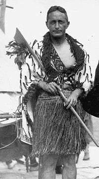
- Rewi Manga Maniapoto - Warrior Chief
- Wahanui - negotiator
- Tiki Taane - singer
- Richard Kahui - rugby player
- Wiremu Te Awhitu - Catholic Priest.
- Sandor Earl - league player
- Rongo Wetere - educationalist
References
- ↑ Evidence to Waitangi Tribunal Rohe Potae Inquiry
- ↑ The Maori King. pp 21-23.J.E Gorst. Reed. Singapore.2001
- ↑ Nga Iwi o Tainui Nga Kooreru Tuku Iho o Nga Tuupuru. P Te Hurinui Jones and B.Biggs.Auckland University Press.1995.
- ↑ Gorst p 141.
- ↑ "Chapter 2: Ngā Wā o Mua: Iwi, Hapū, and their Communities in the Whanganui Inquiry District to circa 1845". New Zealand Ministry of Justice, Tāhū o te Ture. Retrieved 5 June 2016.
- ↑ "The ancestor Maniapoto". Te Ara - the Encyclopedia of New Zealand. Ministry for Culture and Heritage. Retrieved 13 September 2016.
External links
- Maniapoto Trust Board
- Ngati Maniapoto Marae Pact Trust
- Ngāti Maniapoto in Te Ara - the Encyclopedia of New Zealand