Thandwe
| Thandwe သံတွဲမြို့ | |
|---|---|
| Town | |
| Thandwe | |
 Thandwe | |
| Coordinates: 18°28′04.06″N 94°22′05.38″E / 18.4677944°N 94.3681611°E | |
| Country | Myanmar |
| State | Rakhine |
| Township | Thandwe |
| Town | Thandwe |
| Area | |
| • Town | 3,522.798 km2 (1,360.160 sq mi) |
| Population (2014) | |
| • Town | 133,484[1] |
| • Urban | 14,327 |
| Time zone | MST (UTC6:30) |
| Postal code | 0717x |
| Calling code | 4365 |

Thandwe ("Thandway" in Arakanese)(Burmese: သံတွဲမြို့; MLCTS: samtwai: mrui. [θàɴdwɛ́ mjo̰]; formerly Sandoway) is a town and major seaport in Rakhine State, the westernmost part of Myanmar. Thandwe is very ancient, and is said to have been at one time the capital of Rakhine State, then called Arakan. The district has an area of 3,784 square miles (9,800 km2). The country is mountainous, the Arakan Mountains sending out spurs which reach the coast. Some of the peaks in the north attain 4,000 and more ft. The streams are only mountain torrents to within a few miles of the coast; the mouth of the Khwa forms a good anchorage for vessels of from 9 to 10 ft (3.0 m). draught. The rocks in the Arakan Range and its spurs are metamorphic, and comprise clay, slates, ironstone and indurated sandstone; towards the south, ironstone, trap and rocks of basaltic character are common; veins of steatite and white fibrous quartz are also found. Between 1961 and 1990, the mean annual rainfall was 5,323 millimetres (209.6 in). Except a few acres of tobacco, all the cultivation is rice.
Climate
Thandwe has a tropical monsoon climate (Köppen climate classification Am). Temperatures are very warm throughout the year. There is a winter dry season (November–April) and a summer wet season (May–October). Torrential rain falls from June to September, with over 1,200 millimetres (47 in) falling in each of the months of June, July and August. The rainfall in 1905 (?) was 230.49 inches (5,854 mm).
| Climate data for Thandwe | |||||||||||||
|---|---|---|---|---|---|---|---|---|---|---|---|---|---|
| Month | Jan | Feb | Mar | Apr | May | Jun | Jul | Aug | Sep | Oct | Nov | Dec | Year |
| Average high °C (°F) | 30.5 (86.9) |
31.8 (89.2) |
33.4 (92.1) |
34.5 (94.1) |
33.6 (92.5) |
30.1 (86.2) |
29.3 (84.7) |
29.2 (84.6) |
30.7 (87.3) |
32.3 (90.1) |
32.3 (90.1) |
31.0 (87.8) |
31.56 (88.8) |
| Average low °C (°F) | 12.2 (54) |
12.9 (55.2) |
17.3 (63.1) |
22.4 (72.3) |
24.5 (76.1) |
23.8 (74.8) |
23.5 (74.3) |
23.5 (74.3) |
23.4 (74.1) |
22.8 (73) |
19.8 (67.6) |
14.9 (58.8) |
20.08 (68.13) |
| Average precipitation mm (inches) | 2 (0.08) |
1 (0.04) |
1 (0.04) |
17 (0.67) |
299 (11.77) |
1,299 (51.14) |
1,408 (55.43) |
1,404 (55.28) |
614 (24.17) |
206 (8.11) |
64 (2.52) |
8 (0.31) |
5,323 (209.56) |
| Source: HKO (mean values, 1961-1990)[2] | |||||||||||||
Ngapali Beach
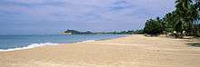
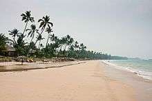
Ngapali Beach is a beach located 7 kilometres (4 mi) from the town of Thandwe (Sandoway), in Rakhine State, Myanmar. It is one of the best known beaches in Myanmar and is a popular tourist destination.
The beach stretches for 3 km (2 mi) and overlooks the Indian Ocean. The name "Ngapali", has no meaning in Burmese, but comes from the Italian "Napoli" (the city of Naples).
Ngapali Beach has been promoted as a major tourist destination in Myanmar. Several resorts and hotels are located in Ngapali, usually of the high end - such as Bayview Ngapali, Amata Resort, Amazing Ngapali and also the government owned Anawa. Ngapali used to have private bungalows, but these were torn down in the late 1990s to make way for the development of hotels. The hotels and small tourism industry help to provide income for the villages around Ngapali and also Thandwe. There is also a golf course nearby.
The beach is served by Thandwe Airport. All of Myanmar's internal airlines, Myanmar National Airlines, Air Mandalay, Yangon Airways, Air KBZ and Air Bagan have frequent flights to Thandwe from most of their destinations. Ngapali's isolation means that few people are able to afford the airfare, thus making it more popular amongst tourists as an unspoilt and private beach.
References
- ↑ "Population of Myanmar". Ministry of Immigration and Population (Myanmar) (in Burmese). 2014-03-29. Retrieved 9 April 2016.
- ↑ "Climatological Information for Thandwe, Myanmar". Hong Kong Observatory. Retrieved January 12, 2013.
-
 This article incorporates text from a publication now in the public domain: Chisholm, Hugh, ed. (1911). "Sandoway". Encyclopædia Britannica (11th ed.). Cambridge University Press.
External links
Capital: Sittwe | ||
| Kyaukpyu District |   | |
| Maungdaw District | ||
| Sittwe District | ||
| Thandwe District |
| |
| Mrauk-U District | ||
| Main cities and towns | ||
Coordinates: 18°28′N 94°22′E / 18.467°N 94.367°E