Norris, South Dakota
| Norris, South Dakota | |
|---|---|
| census-designated place | |
| Coordinates: 43°26′7″N 101°11′28″W / 43.43528°N 101.19111°WCoordinates: 43°26′7″N 101°11′28″W / 43.43528°N 101.19111°W | |
| Country | United States |
| State | South Dakota |
| County | Mellette |
| Area | |
| • Total | 21.3 sq mi (55.1 km2) |
| • Land | 21.2 sq mi (54.9 km2) |
| • Water | 0.1 sq mi (0.1 km2) |
| Elevation | 2,530 ft (771 m) |
| Population (2010) | |
| • Total | 152 |
| • Density | 7.2/sq mi (2.8/km2) |
| Time zone | Central (CST) (UTC-6) |
| • Summer (DST) | CDT (UTC-5) |
| ZIP code | 57560 |
| Area code(s) | 605 |
| FIPS code | 46-45460[1] |
| GNIS feature ID | 1268591[2] |
Norris is an unincorporated community in Mellette County, South Dakota, United States, which is not specifically tracked by the Census Bureau, but rather is only included in the census-designated place of the same name. Norris has the post office which serves the 57560 ZIP code area, which also includes the town of Corn Creek.
Norris was laid out in 1910, and named after a nephew of the town's merchant.[3]
References
- ↑ "American FactFinder". United States Census Bureau. Retrieved 2008-01-31.
- ↑ "US Board on Geographic Names". United States Geological Survey. 2007-10-25. Retrieved 2008-01-31.
- ↑ Federal Writers' Project (1940). South Dakota place-names, v.1-3. University of South Dakota. p. 52.
Municipalities and communities of Mellette County, South Dakota, United States | ||
|---|---|---|
| City | 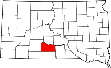 | |
| Town | ||
| CDPs |
| |
| Unincorporated communities | ||
| Indian reservation | ||
| Ghost town | ||
| Footnotes | ‡This populated place also has portions in an adjacent county or counties | |
This article is issued from Wikipedia - version of the 2/3/2016. The text is available under the Creative Commons Attribution/Share Alike but additional terms may apply for the media files.