Northway Airport
| Northway Airport (former Northway Airfield) | |||||||||||
|---|---|---|---|---|---|---|---|---|---|---|---|
 | |||||||||||
|
IATA: ORT – ICAO: PAOR – FAA LID: ORT – WMO: 70291 | |||||||||||
| Summary | |||||||||||
| Airport type | Public | ||||||||||
| Owner | Alaska DOT&PF - Northern Region | ||||||||||
| Serves | Northway, Alaska | ||||||||||
| Elevation AMSL | 1,715 ft / 523 m | ||||||||||
| Coordinates | 62°57′40″N 141°55′41″W / 62.96111°N 141.92806°WCoordinates: 62°57′40″N 141°55′41″W / 62.96111°N 141.92806°W | ||||||||||
| Map | |||||||||||
 ORT Location of airport in Alaska | |||||||||||
| Runways | |||||||||||
| |||||||||||
| Statistics (2005) | |||||||||||
| |||||||||||
Northway Airport (IATA: ORT, ICAO: PAOR, FAA LID: ORT) is a state owned, public use airport serving Northway, a community located in the Southeast Fairbanks Census Area of the U.S. state of Alaska.[1] It is included in the National Plan of Integrated Airport Systems for 2011–2015, which categorized it as a general aviation facility.[2]
During World War II for northbound Lend-Lease aircraft on the Northwest Staging Route, the flight strip at Northway Army Airfield was the first stop in the Territory of Alaska.[3]
Facilities and aircraft
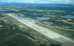
Northway Airport covers an area of 1,150 acres (465 ha) at an elevation of 1,715 feet (523 m) above mean sea level. It has one runway designated 5/23 with an asphalt surface measuring 5,100 by 100 feet (1,554 x 30 m).[1]
For the 12-month period ending December 31, 2005, the airport had 15,800 aircraft operations, an average of 43 per day: 73% general aviation, 25% air taxi, and 2% military.[1]
Airlines and destinations
| Airlines | Destinations |
|---|---|
| 40-Mile Air | Tok[4] |
References
- 1 2 3 4 FAA Airport Master Record for ORT (Form 5010 PDF). Federal Aviation Administration. Effective May 31, 2012.
- ↑ "2011–2015 NPIAS Report, Appendix A" (PDF, 2.03 MB). faa.gov. Federal Aviation Administration. October 4, 2010.
- ↑ Smith, Blake W. Wings Over the Wilderness. Hancock House Publishers, 2008, p. 61.
- ↑ "Scheduled destinations". 40-Mile Air. Retrieved August 2, 2012.
External links
- Topographic map as of July 1955 from USGS The National Map
- FAA Terminal Procedures for ORT, effective December 8, 2016
- Resources for this airport:
- FAA airport information for ORT
- AirNav airport information for PAOR
- ASN accident history for ORT
- FlightAware airport information and live flight tracker
- NOAA/NWS latest weather observations for PAOR
- SkyVector aeronautical chart for ORT