Notre-Dame-des-Bois, Quebec
| Notre-Dame-des-Bois | |
|---|---|
| Municipality | |
|
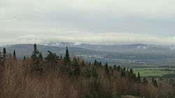
Notre-Dame-des-Bois, Québec (Canada). View from the road to the summit of Mont-Mégantic. | |
 Location within Le Granit RCM. | |
 Notre-Dame-des-Bois Location in southern Quebec. | |
| Coordinates: 45°24′N 71°04′W / 45.400°N 71.067°WCoordinates: 45°24′N 71°04′W / 45.400°N 71.067°W[1] | |
| Country |
|
| Province |
|
| Region | Estrie |
| RCM | Le Granit |
| Constituted | January 1, 1877 |
| Government[2] | |
| • Mayor | Jean-Louis Gobeil |
| • Federal riding | Mégantic—L'Érable |
| • Prov. riding | Mégantic |
| Area[2][3] | |
| • Total | 192.10 km2 (74.17 sq mi) |
| • Land | 191.77 km2 (74.04 sq mi) |
| Population (2011)[3] | |
| • Total | 911 |
| • Density | 4.8/km2 (12/sq mi) |
| • Pop 2006-2011 |
|
| • Dwellings | 825 |
| Time zone | EST (UTC−5) |
| • Summer (DST) | EDT (UTC−4) |
| Postal code(s) | J0B 2E0 |
| Area code(s) | 819 |
| Highways |
|
| Website |
www desbois |
Notre-Dame-des-Bois is a municipality in Le Granit Regional County Municipality in the Estrie region of Quebec, Canada, on the Canada–United States border. The population was 911 as of the Canada 2011 Census.
Located in the Appalachians, it lies at 555 metres in altitude, making it one of the highest towns in Quebec. Mont-Mégantic National Park is located in Notre-Dame-des-Bois and is one of the biggest tourism draws to the region.
Sources
- Commission de toponymie du Québec
- Ministère des Affaires municipales, des Régions et de l'Occupation du territoire
 |
Val-Racine | Piopolis | | |
| Chartierville, La Patrie | |
Saint-Augustin-de-Woburn | ||
| ||||
| | ||||
| Pittsburg, New Hampshire |
Oxford County, Maine |
| Cities | |
|---|---|
| Municipalities | |
| Parishes | |
| Townships | |
| |
This article is issued from Wikipedia - version of the 8/10/2016. The text is available under the Creative Commons Attribution/Share Alike but additional terms may apply for the media files.