Nullarbor Plain
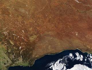
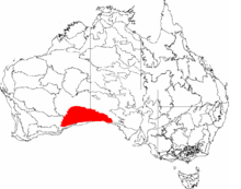
The Nullarbor Plain (/ˈnʌlərbɔːr/ NUL-ər-bor; Latin: nullus, "no", and arbor, "tree"[1]) is part of the area of flat, almost treeless, arid or semi-arid country of southern Australia, located on the Great Australian Bight coast with the Great Victoria Desert to its north. It is the world's largest single exposure of limestone bedrock, and occupies an area of about 200,000 square kilometres (77,000 sq mi).[2] At its widest point, it stretches about 1,100 kilometres (684 mi) from east to west across the border between South Australia and Western Australia.
History
Historically, the Nullarbor, considered by Europeans to be almost uninhabitable, was used by the semi-nomadic Aborigines, the Spinifex and Wangai peoples.
The first Europeans known to have sighted and mapped it were an expedition led by Pieter Nuyts in 1626–27. While the interior remained little known to Europeans over the next two centuries, the name Nuytsland was often applied to the area adjoining the Great Australian Bight. It survives as two geographical names in West Australia : Nuytsland Nature Reserve and Nuyts Land District.
Despite the hardships created by the nature of the Nullarbor, European settlers were determined to cross the plain. Although Edward John Eyre described the Plain as "a hideous anomaly, a blot on the face of Nature, the sort of place one gets into in bad dreams", he became the first European to successfully make the crossing in 1841. Eyre departed Fowler's Bay on 17 November 1840 with John Baxter and a party of three Aboriginal men. When three of his horses died of dehydration, he returned to Fowler's Bay. He departed with a second expedition on 25 February 1841. By 29 April, the party had reached Caiguna. Lack of supplies and water led to a mutiny. Two of the Aborigines killed Baxter and took the party's supplies. Eyre and the third Aborigine, Wylie, continued on their journey, surviving through bushcraft and some fortuitous circumstances, such as receiving some supplies from a French whaling vessel anchored at Rossiter Bay. They completed their crossing in June 1841.
In August 1865, while travelling across the Nullarbor, E. A. Delisser in his journal named both Nullarbor and Eucla for the first time.[3]
A proposed new state of Auralia (meaning "land of gold") would have comprised the Goldfields, the western portion of the Nullarbor Plain and the port town of Esperance. Its capital would have been Kalgoorlie.
During the British nuclear tests at Maralinga in the 1950s, the government forced the Wangai to abandon their homeland. Since then they have been awarded compensation, and many have returned to the general area. Others never left.
Some agricultural interests are on the fringe of the plain including the 2.5 million acre Rawlinna Station, the largest sheep station in the world, on the Western Australian side of the plain. The property was established in 1962 by Hugh G. MacLachlan, of the South Australian pastoral family, the station has a comparatively short history compared to other properties of its type around Australia.[4] An older property is Madura Station, situated closer to the coast, it has a size of 1.7 million acres and is also stocked with sheep.[5] Madura was established prior to 1927, the extent of the property at that time was reported as two million acres.[6]
In 2011 South Australian Premier Mike Rann announced that a huge area of the Nullarbor, stretching almost 200 km (120 mi) from the WA border to the Great Australian Bight, would be given formal Wilderness Protection Status. Mr Rann said the move would double the area of land in South Australia under environmental protection, to 1.8 million hectares. The area contains 390 species of plants and a large number of habitats for rare species of animals and birds.[7]
Cultural significance

"Crossing the Nullarbor", for many Australians, is a quintessential experience of the "Australian Outback". Stickers bought from roadhouses on the highway show "I have crossed the Nullarbor", and can be seen on vehicles of varying quality or capacity for long distance travel. The process of "beating the crowds" on overbooked air services at the time of special sporting events can also see significant numbers of vehicles on the road.
Crossings in the 1950s and earlier were significant, as most of the route then was a dirt track. Round-Australia car trials (the Redex Trials)[8][9] used the Nullarbor crossing for good photo shoots of cars negotiating poor track.
Geography and climate
The Nullarbor Plain is a former shallow seabed, as indicated by the presence of bryozoans, foraminifera, echinoids and red algae calcareous skeletons that make up the limestone.[10] The region is also the location of "Nullarbor limestone" and it has a reputation as a significant karst region[11] with Oligocene and Miocene cave formations.[10][12]
The sequence within the limestone includes five formations:
- the upper formation is the Nullarbor Limestone which is early middle Miocene in age;
- the Mullamullang member of this formation is a paraconforming member, being separated by 5 million years;[10]
- the third member is the Abrakurrie Limestone that was formed in a central depression of the earlier formation; this is late Oligocene to Early Miocene in age and does not reach the edge of the plain;[10]
- the last two formations are conforming formations; the late Eocene Toolinna Limestone lies on the Wilsons Bluff Limestone which is mid to late Eocene in age; and
- the Toolinna Limestone does not cover the whole Nullarbor and is extant only in the extreme east beside the Abrakurrie formation which lies in a depression.

One theory is that the whole area was uplifted by crustal movements in the Miocene, and since then, erosion by wind and rain has reduced its thickness. The plain has most likely never had any major defining topographic features, resulting in the extremely flat terrain across the plain today.[10]
In areas, the southern ocean blows through many subterranean caves, resulting in blowholes up to several hundred metres from the coast. The Murrawijinie Cave in South Australia is open to the public, but most of the Nullarbor Caves on the Western Australian side can only be visited and viewed with a permit from the Department of Parks and Wildlife.
The Nullarbor is known for extensive meteorite deposits, which are extremely well preserved in the arid climate. In particular, many meteorites have been discovered around Mundrabilla, some up to several tonnes in weight.[13]
According to the United States Department of Agriculture, the Nullarbor's soils are considered to be mainly aridisols.[14]

The Nullarbor has a desert climate, with arid to semi-arid conditions. Inland, summers can be scorching hot, with daytime temperatures close to 50 °C (122 °F), while in winter nights can drop well below freezing. Closer to the coast, the temperature is milder with more rainfall in the winter months. The mean annual rainfall at Cook is 184.1 millimetres (7.25 in), with most rain falling between May and August. Summers are very dry, with rain falling mainly from sporadic storms, however occasionally decaying tropical systems can cause heavier rain in the summer months.[15] Temperatures on the plain have ranged from 49.8 °C (121.6 °F) at Mundrabilla and Forrest which is the 4th hottest recorded temperature in all of Australia,[16] to −7.2 °C (19.0 °F) at Eyre, which is the coldest recorded temperature in Western Australia.[17]
Communications and transport
Telegraph
The need for a communications link across the continent was the spur for the development of an east–west crossing. Once Eyre had proved that a link between South Australia and Western Australia was possible, efforts to connect them via telegraph began. In 1877, after two years of labour, the first messages were sent on the new telegraph line, boosted by eight repeater stations along the way. The line operated for about 50 years before being superseded, and remnants of it remain visible.
Railway line
The Trans-Australian Railway railway line crosses the Nullarbor Plain from Kalgoorlie to Port Augusta. Construction of the line began in 1917, when two teams set out from Kalgoorlie in Western Australia and Port Augusta in South Australia, meeting in the centre of the Plain at Ooldea, an uninhabited area noted for a water supply. This original line suffered severe problems with track flexing and settling in the desert sands, and journeys across the Plain were slow and arduous. The line was entirely rebuilt in 1969, as part of a project to standardise the previously disparate rail gauges in the various states, and the first crossing of the Nullarbor on the new line reached Perth on 27 February 1970. The Indian Pacific is a regular passenger train crossing the Nullarbor from Perth to Sydney via Adelaide.
The railway line has the longest straight section of railway in the world (478 km, 297 mi),[18] while the Eyre Highway (refer below) contains the longest straight section of tarred road in Australia (146.6 km, 91.1 mi).
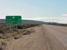
Most of the inhabited areas of the Nullarbor Plain can be found in a series of small settlements located along the railway, and in small settlements along the Eyre Highway that provide services to travellers, mostly spaced between one and two hundred kilometres apart. The town of Cook, in South Australia, was formerly a moderately thriving settlement of about 40 people, with a school and a golf course. The reduction of railway operations at the town resulted in its virtual desertion, and it now has a permanent population of four. The Tea and Sugar Train operated until 1996, supplying provisions to the town along the railway line.
Road
The Eyre Highway, which connects Norseman in Western Australia to Port Augusta, was carved across the continent in 1941. At first it was little more than a rough track, but was gradually sealed over the next thirty years. The last unsealed section of the Eyre Highway was finally sealed in 1976.[19] Unlike the railway, though, it crosses the plain at its southernmost edge rather than through the centre.
Biogeography
Nullarbor is a biogeographic region under the Interim Biogeographic Regionalisation for Australia (IBRA)[20][21] and the Nullarbor Plains Xeric Shrubland ecoregion of the World Wildlife Fund.[22]
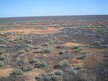
Vegetation in the area is primarily low saltbush and bluebush scrub. A large part of the Nullarbor Plain is now a National Park.
The fauna of the Nullarbor includes communities of crustaceans, spiders, and beetles adapted to the darkness of the Nullarbor Caves and the underground rivers and lakes that run through them. Mammals of the desert include the southern hairy-nosed wombat which shelters from the hot sun by burrowing into the sands, as well as typical desert animals such as red kangaroos and dingoes. An elusive subspecies of the Australian masked owl unique to the Nullarbor is known to roost in the many caves on the plain. The grasslands of the Nullarbor are suitable for some sheep grazing and are also damaged by rabbits.
Limits
Frequently The Nullarbor is expanded in tourist literature and web-based material to loosely refer to all the land between Adelaide, South Australia and Perth, Western Australia. Through observing satellite images, the limits of the limestone formation of the plain can be seen to stretch from approximately 20 kilometres (12 mi) west of the original Balladonia settlement (now abandoned) to its Easternmost limit a few kilometres West of the town of Ceduna.[23]
Notable Crossings & Records
On bicycles
On 25 December 1896, after an arduous journey of thirty-one days, Arthur Charles Jeston Richardson became the first cyclist to cross the Nullarbor Plain, pedaling his bicycle from Coolgardie to Adelaide.[24] Carrying only a small kit and a water-bag, he followed the telegraph line as he crossed the Nullarbor. He later described the heat as "1,000 degrees in the shade".[25] During their three-year cycling trip around Australia between 1946 and 1949, Wendy Law Suart and Shirley Duncan became the first women to cycle across the Plain.[26]
Between 29 June and 3 July 2015, brothers Tyron and Aaron Bicknell recorded the fastest known crossing of the Nullarbor Plain on single speed bicycles. Their ride took advantage of the cold temperatures in the Australian winter months and was completed over 4 days, 5 hours and 21 minutes, making it one of the fastest bicycle crossings and the fastest done with a single geared bike.[27][28]
On foot
The first non-Indigenous person to walk across Australia from the west to the east coast, Henri Gilbert, crossed the Nullarbor Plain on foot, with no support team or stock, in the middle of summer. His walk across Australia, from Fremantle to Brisbane, was achieved between August 1897 and December 1898.[29] In 1998, runner Robert Garside ran across the Nullarbor without a formal support crew, as part of an authenticated run around the world.[30][31] Unconventionally, Garside obtained water and other support from "passing traffic" who would leave water cached ahead for him at agreed drop-offs, to achieve the feat.[32] In 2010, columnist Dan Koeppel ran the 200 mile (320 km) heart of the Nullarbor with a friend the same way, to vindicate Garside.[32] Garside commented in his diary, that "the key to running the Nullarbor turned out to be Australian hospitality",[32] and Koeppel concurred that "[F]rom an armchair it is completely impossible to run the Nullarbor. Once you're out there, however, there is a way. Robert Garside discovered it. So would I".[32]
See also
- Bunda cliffs
- Nullarbor Links golf course
- Nullarbor National Park, a protected area in South Australia
- Nullarbor Nymph, a hoax
- Nullarbor Regional Reserve, a protected area in South Australia
- Nullarbor, South Australia, a locality within the Nullarbor Plain in South Australia
- Nullarbor Wilderness Protection Area, a protected area in South Australia
References
- ↑ Macquarie Dictionary (2nd ed.). Macquarie University. 1991. p. 1220. ISBN 0 949757 63 2.
- ↑ "Across the Nullarbor Plain". Kevin's Wilderness Journeys. 7 June 2004. Archived from the original on 10 October 2007.
- ↑ Journal of the Great Australian Bight Expedition, May–October 1865, recording the exploration and naming of the Nullarbor Plain. Written in pencil and ink, the journal covers the dates 1 May to 5 October. Both volumes include mounted and identified botanical specimens, with some since lost or deteriorated. Book II includes a sketch plan entitled "Bight Country -The two catacombs near Kuelna [Colona?] July 16 Sunday −1865". This volume appears to contain the first written use of the name Nullarbor Plain under the date Friday 18 August 1865. – see http://trove.nla.gov.au/work/34692051
- ↑ "Rawlinna". Jumbuck Pastoral. 2012. Retrieved 22 January 2013.
- ↑ "Madura". Jumbuck Pastoral. 2012. Retrieved 21 February 2013.
- ↑ "Madura Station – 2,000,000 Acres". The Sydney Mail. 20 July 1927. Retrieved 22 February 2013.
- ↑ ABC News, 25 March 2011
- ↑ "Nullarbor present Redex hazard.". The Advocate. Burnie, Tas.: National Library of Australia. 17 July 1954. p. 2. Retrieved 28 December 2013.
- ↑ "Redex men on the Nullarbor.". The Argus. Melbourne: National Library of Australia. 17 July 1954. p. 1. Retrieved 28 December 2013.
- 1 2 3 4 5 John A. Webb & Julia M. James (2006). "Karst evolution of the Nullarbor Plain, Australia". In Russell S. Harmon & Carol M. Wicks. Perspectives on Karst Geomorphology, Hydrology and Geochemistry – a Tribute Volume to Derek C. Ford and William B. White (PDF). Geological Society of America Special Paper 404. pp. 65–78. doi:10.1130/2006.2404(07). ISBN 978-0-8137-2404-1.
- ↑ Lipar, M., Ferk, M., (2015). Karst pocket valleys and their implications on Pliocene-Quaternary hydrology and climate: examples from the Nullarbor Plain, southern Australia. Earth-Science Reviews 150, p. 1-13.
- ↑ Stratigraphic Search – Full Results – Geoscience Australia
- ↑ The Meteoretical Bulletin, No. 77, 1994 November
- ↑ "Global Soil Regions". United States Department of Agriculture. November 2005. Retrieved 14 September 2013.
- ↑ "Climate statistics for Australian locations". Bureau of Meteorology. 7 March 2013. Retrieved 10 March 2013.
- ↑ "Official records for Australia". Daily Extremes. Bureau of Meteorology. 30 September 2015. Retrieved 21 December 2015.
- ↑ "Rainfall and Temperature Records: National" (PDF). Bureau of Meteorology. Retrieved 14 November 2009.
- ↑ Vincent, Peter (27 September 2006). "Railroaded Into Fun". The Age. Retrieved 25 January 2008.
- ↑ "Road links to the East". State Library of Western Australia. Retrieved 2008-09-27.
- ↑ Environment Australia. "Revision of the Interim Biogeographic Regionalisation for Australia (IBRA) and Development of Version 5.1 – Summary Report". Department of the Environment and Water Resources, Australian Government. Archived from the original on 5 September 2006. Retrieved 31 January 2007.
- ↑ IBRA Version 6.1 data
- ↑ "Nullarbor Plain xeric shrublands". Terrestrial Ecoregions. World Wildlife Fund.
- ↑ A tourist map of the Nullarbor Plain Perth to Adelaide Scale 1:2,250,000 (E 116°00’ --E 139°00’/S 30°00’--S 38°00’) Unley, S. Aust. : Carto Graphics, ISBN 0-9579060-4-8
- ↑ Fitzpatrick, Jim, "Richardson, Arthur Charles Jeston (1872–1939)", Australian Dictionary of Biography, Volume 11, Melbourne University Press (1988), p. 379
- ↑ Fitzpatrick, p. 379
- ↑ Steger, Jason (22 November 2008). "Around the country with bags and swags and bicycles, too". The Age. Retrieved 24 January 2013.
- ↑ https://www.strava.com/athletes/1153448
- ↑ https://www.strava.com/athletes/155360
- ↑ http://www.uq.edu.au/news/article/2000/10/new-book-reveals-hardships-endured-french-adventurer
- ↑ "Man's record run around the world". BBC. 27 March 2007. Retrieved 14 October 2010.
- ↑ Hughes, Paul (26 March 2007). ""Runningman" makes it into record books at last". Reuters. Retrieved 20 December 2014.
- 1 2 3 4 It took over ten years to get this story published: Redemption of the Runningman - Dan Koeppel's blog, Bananas, Los Angeles, and Transit Geekery, 2012-07-13 (archive.org copy); full PDF of the writing is also linked from the blog post; it is also republished in The Best American Sports Writing 2013, Ed. Stout & Moehringer, ISBN 0547884605 | 978-0547884608.
Further reading
- Bolam, A. G. (Anthony Gladstone), 1893–1966. The trans-Australian wonderland Melbourne : Modern Printing, (many editions in the early 20th century)
- Edmonds, Jack (1976) Nullarbor crossing : with panorama photographs by Brian Gordon. Perth. West Australian Newspapers, Periodicals Division. ISBN 0-909699-09-7
External links
| Wikimedia Commons has media related to Nullarbor. |
- Nullarbor Net
- Across The Nullarbor Travel story by Roderick Eime
- Information about crossing the Nullarbor
- Eyre Bird Observatory
- Climate charts
- History of the rail crossing
- Mundrabilla meteorite information
- Caverns give up huge fossil haul BBC News Online, 25 January 2007. Retrieved 25 January 2007
- aerial video footage of the Nullarbor Plain
- Photo Essay on Driving Australia's Nullarbor Plain
- Governmental Biodiversity Assessment of the Nullarbor Plain
| Topics | ||
|---|---|---|
| Regions | ||
| Cities and towns | ||
South Australia portal | ||