Nusa Lembongan
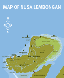
Nusa Lembongan is an island located southeast of Bali, Indonesia at 8°40.906′S 115°27.067′E / 8.681767°S 115.451117°ECoordinates: 8°40.906′S 115°27.067′E / 8.681767°S 115.451117°E. It is part of a group of three islands that make up the Nusa Penida district, of which it is the most famous.[1] This island group in turn is part of the Lesser Sunda Islands.
Administration
Administratively, the island is part of a subdistrict of Klungkung regency. Nusa Lembongan is one of three small offshore islands which make up a sub-regency of Klungkung, the others being: Nusa Penida and Nusa Ceningan.[2] Nusa Lembongan has the vast majority of the tourist infrastructure within the sub-regency and is a popular side destination for visitors to mainland Bali.
Geography and transport


Nusa Lembongan is approximately 8 square kilometres in area with a permanent population estimated at 5,000.[3] Twelve kilometres of the Badung Strait separates Nusa Lembongan from Bali Island. The island is surrounded by coral reefs with white sand beaches and low limestone cliffs. Nusa Lembongan is separated from Nusa Ceningan by a shallow estuarine channel which is difficult to navigate at low tide. There are no permanent waterways on Nusa Lembongan. There was a suspension bridge linking Nusa Lembongan and Nusa Ceningan which took foot and motorbike traffic only. However, the bridge collapsed on October 16, 2016, leading to eight deaths and thirty injuries. At the time, local officials had no estimate on the repair or replacement of the bridge.[4] (The bridge is currently being rebuild and expected to become operational once again by February 1st 2017).
There are three main villages on the island. Jungut Batu and Mushroom Bay are the centres of the tourist-based industry and activities on the island[5] whilst much of the permanent local population resides in Lembongan Village.
To the east, the Lombok Strait separates the three islands from Lombok, and marks the biogeographical division between the fauna of the Indomalayan ecozone and the distinctly different fauna of Australasia. The transition is known as the Wallace Line, named after Alfred Russel Wallace, who first proposed a transition zone between these two major biomes.
The north-eastern side of the island is flanked by a relatively large area of mangroves totalling some 212 hectares.[6]
Nusa Lembongan is served by regular direct speed-boat services, mostly from the east-coast Bali resort town of Sanur. Crossing time is approximately 30 minutes and services run at regular intervals during daylight hours. Larger cargo boats also run daily from the Bali port town of Padang Bai.
Local economy

The economy is largely based on tourism and Nusa Lembongan is the only one of the three neighbouring islands to have any significant tourism-based infrastructure. There is also subsistence agriculture and fishing[7] on the island and a seaweed farming micro-industry.[8]

Conservation issues
Marine conservation is considered extremely important to sustaining future levels of tourism on the island and in February 2009, a local NGO from Nusa Lembongan, facilitated by The Nature Conservancy Coral Triangle Center, opened a community centre on Nusa Lembongan. The waters around Nusa Lembongan and Nusa Penida have at least 247 species of coral and 562 species of reef fish.[9]
Other conservation initiatives include a release programme of critically endangered Olive Ridley Turtles from Sunset Beach on the south western coast.[10][11]
References
- ↑ Post, The Jakarta. "Administration to improve access to Nusa Penida".
- ↑ Government Office of the Regency of Klungkung
- ↑ Sunset (27 May 2009). "All about Nusa Lembongan".
- ↑ "Deadly bridge collapse off Indonesia's Bali island". BBC News. 16 October 2016. Retrieved 16 October 2016.
- ↑ "Nusa lembongan Property: all about Nusa Lembongan".
- ↑ "Survey and Condition of the Mangrove Forest at Nusa Lembongan and Nusa Ceningan" (PDF).
- ↑ Post, The Jakarta. "Residents lack tools to monitor destructive fishing".
- ↑ "Report On The Training Course On gracilaria Algae Manila, Philippines 1–30 April 1981".
- ↑ "Coral Triangle Center - Ensuring coral reefs for life".
- ↑ Sunset (6 July 2009). "Visitors to Nusa Lembongan doing their bit to save sea turtles".
- ↑ Post, The Jakarta. "Baby sea turtles head off on a big adventure".
External links
![]() Media related to Nusa Lembongan at Wikimedia Commons
Media related to Nusa Lembongan at Wikimedia Commons
-
 Nusa Lembongan travel guide from Wikivoyage