Nweyon
| Nweyon | |
|---|---|
| Village | |
 Nweyon | |
| Coordinates: 22°53′N 96°7′E / 22.883°N 96.117°ECoordinates: 22°53′N 96°7′E / 22.883°N 96.117°E | |
| Country |
|
| Division | Mandalay Division |
| District | Pyin Oo Lwin District |
| Township | Singu Township |
| Elevation | 497 ft (151 m) |
| Time zone | MMT (UTC+6:30) |
Nweyon is a village in Singu Township, Pyinoolwin District, Mandalay Division, Myanmar.[1]
It is located about 2 km east of Letha Taung, also known as the Singu Plateau, near National Highway 31.[2]
References
- ↑ Maplandia - Nweyon
- ↑ "Letha Taung". Mapcarta. Retrieved 1 June 2016.
Capital: Singu | |
|
Capital: Mandalay | ||
| Kyaukse District |  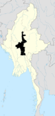 | |
| Mandalay District | ||
| Meiktila District | ||
| Myingyan District | ||
| Nyaung-U District |
| |
| Pyinoolwin District |
| |
| Yamethin District | ||
| Main cities and towns | ||
This article is issued from Wikipedia - version of the 6/1/2016. The text is available under the Creative Commons Attribution/Share Alike but additional terms may apply for the media files.