Pyigyidagun Township
| Pyigyidagun Township | |
|---|---|
| Township of Mandalay | |
| Pyigyidagun Township | |
 Pyigyidagun Township | |
| Coordinates: 21°55′0″N 96°5′0″E / 21.91667°N 96.08333°ECoordinates: 21°55′0″N 96°5′0″E / 21.91667°N 96.08333°E | |
| Country |
|
| Division | Mandalay |
| City | Mandalay |
| Township | Pyigyidagun |
| Time zone | MST (UTC6:30) |
| Area code(s) | 2 (mobile: 69, 90)[1] |
Pyigyidagun Township (also spelled Pyigyitagun Township; pronounced: [pjìdʑí dəɡʊ̀ɴ mjo̰nɛ̀]) is located in the southern part of Mandalay, Myanmar. The township is bounded by Chanmyathazi township in the north and the west, and Amarapura in the south.[2]
References
- ↑ "Myanmar Area Codes".
- ↑ "Map of Mandalay". DPS. Retrieved 2009-04-04.
Capital: Mandalay | ||
| Kyaukse District |  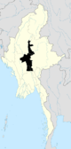 | |
| Mandalay District | ||
| Meiktila District | ||
| Myingyan District | ||
| Nyaung-U District |
| |
| Pyinoolwin District |
| |
| Yamethin District | ||
| Main cities and towns | ||
| States | ||
|---|---|---|
| Regions | ||
| Self-Administered Zones | ||
| Self-Administered Divisions | ||
| Union Territories | ||
This article is issued from Wikipedia - version of the 7/3/2015. The text is available under the Creative Commons Attribution/Share Alike but additional terms may apply for the media files.