Mandalay
| Mandalay မန္တလေး | |
|---|---|
 | |
 Mandalay Location of Mandalay, Myanmar (Burma) | |
| Coordinates: 21°58′30″N 96°5′0″E / 21.97500°N 96.08333°ECoordinates: 21°58′30″N 96°5′0″E / 21.97500°N 96.08333°E | |
| Country |
|
| Region | Mandalay Region |
| District | Mandalay District |
| Government | |
| • Mayor | Ye Lwin |
| Area[1] | |
| • City | 163.84 km2 (63.26 sq mi) |
| Elevation | 22 m (70 ft) |
| Population (2014 census)[2][3] | |
| • City | 1,225,133 |
| • Density | 7,500/km2 (19,000/sq mi) |
| • Metro | 1,022,487 |
| • Ethnic groups | Bamars, Indian, Chinese, Shan |
| • Religions | Theravada Buddhism, Christianity, Hinduism, Islam |
| Time zone | MMT (UTC+6:30) |
| Area code(s) | 2 (mobile: 20,69, 90)[4] |
Mandalay (/ˌmændəˈleɪ/ or /ˈmændəleɪ/; Burmese: မန္တလေး; MLCTS: manta.le: [màɴdəlé]) is the second-largest city and the last royal capital of Myanmar (Burma). Located 716 km (445 mi) north of Yangon on the east bank of the Irrawaddy River, the city has a population of 1,225,553 (2014 census).
Mandalay is the economic centre of Upper Burma and considered the centre of Burmese culture. A continuing influx of Chinese immigrants, mostly from Yunnan, in the past twenty years, has reshaped the city's ethnic makeup and increased commerce with China.[5][6] Despite Naypyidaw's recent rise, Mandalay remains Upper Burma's main commercial, educational and health center.
Etymology
The city gets its name from the nearby Mandalay Hill. The name is probably a derivative of a Pali word, although the exact word of origin remains unclear. The root word has been speculated to be mandala, referring to circular plains[3] or Mandara, a mountain from Hindu mythology.[7]
When it was founded in 1857, the royal city was officially named Yadanabon (ရတနာပုံ, [jədənàbòʊɴ]), a loan of the Pali name Ratanapūra (ရတနပူရ) "City of Gems."[8][9] It was also called Lay Kyun Aung Myei (လေးကျွန်းအောင်မြေ, [lé dʑʊ́ɴ àʊɴ mjè], "Victorious Land over the Four Islands") and Mandalay Palace (မြနန်းစံကျော်, [mja̰ náɴ sàɴ tɕɔ̀], "Famed Royal Emerald Palace").
History
Early history
Like most former (and present) capitals of Burma, Mandalay was founded on the wishes of the ruler of the day. On 13 February 1857, King Mindon founded a new royal capital at the foot of Mandalay Hill, ostensibly to fulfill a prophecy on the founding of a metropolis of Buddhism in that exact place on the occasion of the 2,400th jubilee of Buddhism.[10]
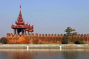
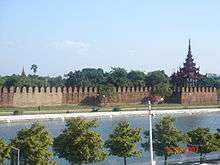
The new capital city site was 66 km2 (25.5 sq mi) in area, surrounded by four rivers. The plan called for a 144-square block grid patterned citadel, anchored by a 16 square block royal palace compound at the center by Mandalay Hill.[11] The 1020-acre (413-hectare) citadel was surrounded by four 2,032 m (6,666 ft) long walls and a moat 64 m (210 ft) wide, 4.6 m (15 ft) deep. At intervals of 169 m (555 ft) along the wall, were turrets with gold-tipped spires for watchmen.[12] The walls had three gates on each side, and five bridges to cross the moat.[11] In addition, the king also commissioned the Kuthodaw Pagoda, the Pahtan-haw Shwe Thein upasampada hall, the Thudamma "Good Dharma" zayats (IPA: [zəjaʔ]) or public houses for preaching Buddhism and a library for the Pāli Canon.
In June 1857, the former royal palace of Amarapura was dismantled and moved by elephants to the new location at the foot of Mandalay Hill, although construction of the palace compound was officially completed only two years later, on Monday, 23 May 1859.[10]
For the next 26 years, Mandalay was to be the last royal capital of the Konbaung Dynasty, the last independent Burmese kingdom before its final annexation by the British Empire. Mandalay ceased to be the capital on 28 November 1885 when the conquering British sent Thibaw Min and his queen Supayalat into exile, ending the Third Anglo-Burmese War.
Colonial Mandalay (1885–1948)

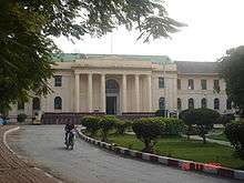
While Mandalay would continue to be the chief city of Upper Burma during the British colonial rule, the commercial and political importance had irreversibly shifted to Yangon. The British view on the development of Mandalay (and Burma) was mainly with commercial intentions. While rail transport reached Mandalay in 1889,[13] less than four years after the annexation, the first college in Mandalay, Mandalay College, was not established until 40 years later, in 1925.[14] The British looted the palace, with some of the treasures still on display in the Victoria and Albert Museum,[15] also renaming the palace compound Fort Dufferin and used it to billet troops.

Throughout the colonial years, Mandalay was the centre of Burmese culture and Buddhist learning, and as the last royal capital, was regarded by the Burmese as a primary symbol of sovereignty and identity. Between the two World Wars, the city was Upper Burma's focal point in a series of nationwide protests against the British rule. The British rule brought in many immigrants from India to the city. In 1904–05, a plague caused about one-third of the population to flee the city.[3]
During World War II, Mandalay suffered the most devastating air raids of the war. On April 3, 1942, during the Japanese conquest of Burma, the Imperial Japanese Army Air Service carried out an extensive assault on the city. As the city was defenseless and its firefighting were weak that had been lost in the earlier bombing and that they met no opposition from the British RAF as all its aircraft had by now been withdrawn to India, three-fifths of the houses were destroyed and 2,000 civilians were killed.[16][17][18] Many again fled the city when the city was under Japanese occupation from May 1942 to March 1945. The palace citadel, turned into a supply depot by the Japanese, was burnt to the ground by Allied bombing; only the royal mint and the watch tower survived. (A faithful replica of the palace was rebuilt in the 1990s.)
Contemporary Mandalay (1948–present)
After the country gained independence from Britain in 1948, Mandalay continued to be the main cultural, educational and economic hub of Upper Burma. Until the early 1990s, most students from Upper Burma went to Mandalay for university education. Until 1991, Mandalay University, the University of Medicine, Mandalay and the Defence Services Academy were the only three universities in Upper Burma. Only a few other cities had "Degree Colleges" affiliated with Mandalay University that offered a limited number of subjects. Today, the city attracts a fraction of students as the military government requires students to attend their local universities in order to reduce concentration of students in one place.
In November 1959, Mandalay celebrated its centennial with a festival at the foot of Mandalay Hill. Special commemorative stamps were issued.[19]
During Ne Win's isolationist rule (1962–1988), the city's infrastructure deteriorated. By the early 1980s, the second largest city of Burma resembled a town with low-rise buildings and dusty streets filled mostly with bicycles. In the 1980s, the city was hit by two major fires. In May 1981, a fire razed more than 6,000 houses and public buildings, leaving more than 36,000 homeless. On 24 March 1984, another fire destroyed 2,700 buildings and made 23,000 people homeless.[20][21]
Fires continue to plague the city. A major fire destroyed Mandalay's second largest market, Yadanabon Market, in February 2008, and another major fire in February 2009 destroyed 320 homes and left over 1600 people homeless.[22][23]
The 1980s fires augured a significant change in the city's physical character and ethnic makeup. Huge swaths of land left vacant by the fires were later purchased, mostly by the ethnic Chinese, many of whom were recent immigrants from Yunnan.[24] The Chinese influx accelerated after the current State Peace and Development Council came to power in 1988. With the Burmese government turning a blind eye, many Chinese immigrants from Yunnan (and also from Sichuan) poured into Upper Burma in the 1990s and many openly ended up in Mandalay.[6] In the 1990s alone, about 250,000 to 300,000 Yunnanese are estimated to have migrated to Mandalay.[25] Today, ethnic Chinese people are believed to make up about 40%–50% of the city's population that rival the locals,[25] and are a major factor in the city's doubling of population from about 500,000 in 1980 to one million in 2008. Chinese festivals are now firmly embedded in the city's cultural calendar.[24] It is a common Burmese complaint that Mandalay is becoming little more than a satellite of China and that the romance of old Mandalay is long gone[26]
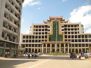
The Chinese are largely responsible for the economic revitalization of the city centre, now rebuilt with apartment blocks, hotels and shopping centres, and returning the city to its role as the trading hub connecting Lower Burma, Upper Burma, China and India. The Chinese dominance in the city center has pushed out the rest to the suburbs. The urban sprawl now encompasses Amarapura, the very city King Mindon left some 150 years ago. Mandalay celebrated its 150th birthday on 15 May 2009, at precisely 4:31:36 am.[3]
Despite the rise of Naypyidaw, the country's capital since 2006, Mandalay remains Upper Burma's main commercial, educational and health center.
Geography
Location
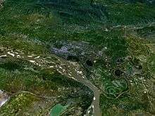
Mandalay is located in the central dry zone of Burma by the Irrawaddy river at 21.98° North, 96.08° East, 80 meters (260 feet) above sea level. Its standard time zone is UTC/GMT +6:30 hours.
Mandalay lies along the Sagaing Fault, a tectonic plate boundary between the India and Sunda plates. (The biggest earthquake in its history, with a magnitude of 7, occurred in 1956.[27] The devastation was greatest in nearby Sagaing, and it came to be known as the Great Sagaing Quake.)
Climate
Mandalay features a tropical wet and dry climate under the Köppen climate classification. Mandalay features noticeably warmer and cooler periods of the year. Average temperatures in January, the coolest month, hovers around 21 °C while the warmest month, April, averages 31 °C. Mandalay is very hot in the months of April and May, with average high temperatures easily exceeding 35 °C. It is not uncommon to see high temperatures surpass 40 °C during these two months in the city. Mandalay also features wet and dry seasons of nearly equal length, with the wet season running from May through October and the dry season covering the remaining six months. The highest reliably recorded temperature in Mandalay is 48.0 °C (118.4 °F) on April 24, 1975 while the lowest is 7.6 °C (45.7 °F) on December 26, 1999.[28]
| Climate data for Mandalay (1961–1990, extremes 1889–present) | |||||||||||||
|---|---|---|---|---|---|---|---|---|---|---|---|---|---|
| Month | Jan | Feb | Mar | Apr | May | Jun | Jul | Aug | Sep | Oct | Nov | Dec | Year |
| Record high °C (°F) | 37.2 (99) |
39.2 (102.6) |
42.8 (109) |
48.0 (118.4) |
45.0 (113) |
42.0 (107.6) |
41.6 (106.9) |
39.8 (103.6) |
43.4 (110.1) |
39.2 (102.6) |
38.5 (101.3) |
34.0 (93.2) |
48.0 (118.4) |
| Average high °C (°F) | 28.6 (83.5) |
32.1 (89.8) |
35.8 (96.4) |
38.4 (101.1) |
36.8 (98.2) |
34.2 (93.6) |
34.3 (93.7) |
32.3 (90.1) |
33.1 (91.6) |
32.2 (90) |
30.2 (86.4) |
28.2 (82.8) |
33.0 (91.4) |
| Daily mean °C (°F) | 21.0 (69.8) |
23.5 (74.3) |
27.8 (82) |
31.4 (88.5) |
31.3 (88.3) |
30.0 (86) |
30.1 (86.2) |
28.8 (83.8) |
29.0 (84.2) |
27.9 (82.2) |
24.8 (76.6) |
21.5 (70.7) |
27.26 (81.05) |
| Average low °C (°F) | 13.3 (55.9) |
14.9 (58.8) |
19.7 (67.5) |
24.4 (75.9) |
25.8 (78.4) |
25.8 (78.4) |
25.8 (78.4) |
25.2 (77.4) |
24.9 (76.8) |
23.5 (74.3) |
19.4 (66.9) |
14.8 (58.6) |
21.5 (70.6) |
| Record low °C (°F) | 8.0 (46.4) |
10.0 (50) |
12.8 (55) |
13.0 (55.4) |
17.4 (63.3) |
20.0 (68) |
20.0 (68) |
19.5 (67.1) |
20.5 (68.9) |
18.5 (65.3) |
11.1 (52) |
7.6 (45.7) |
7.6 (45.7) |
| Average rainfall mm (inches) | 4 (0.16) |
2 (0.08) |
1 (0.04) |
40 (1.57) |
138 (5.43) |
116 (4.57) |
83 (3.27) |
136 (5.35) |
150 (5.91) |
125 (4.92) |
38 (1.5) |
6 (0.24) |
839 (33.03) |
| Average rainy days | 0.4 | 0.4 | 0.4 | 3.3 | 8.3 | 7.2 | 5.9 | 8.7 | 8.1 | 6.8 | 2.8 | 0.7 | 53.0 |
| Average relative humidity (%) | 68 | 58 | 49 | 50 | 66 | 73 | 71 | 76 | 76 | 77 | 74 | 72 | 67.5 |
| Mean monthly sunshine hours | 309 | 280 | 301 | 291 | 267 | 208 | 182 | 168 | 215 | 223 | 269 | 278 | 2,991 |
| Source #1: World Meteoroglogical Organization,[29] Meteo Climat (record highs and lows)[28] | |||||||||||||
| Source #2: Danish Meteorological Institute (sun and relative humidity)[30] | |||||||||||||
Cityscape


Around the city
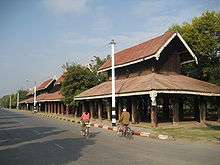
- Atumashi Monastery: The "Atumashi kyaung", which literally means "inimitable vihara", is also one of the well known sights. The original structure was destroyed by a fire in 1890 though the masonry plinth survived. It was indeed an inimitable one in its heyday. The reconstruction project was started by the government on 2 May 1995 and completed in June 1996.
- Buddha's Replica Tooth Relic Pagoda: One of the Buddha's Sacred Replica Tooth Relics was enshrined in the Mandalay Swedaw Pagoda on Maha Dhammayanthi Hill in Amarapura Township. The pagoda was built with cash donations contributed by the peoples of Burma and Buddhist donors from around the world under the supervision of the State Peace and Development Council. The authorities and donors hoisted Buddha's Replica Tooth Relic Pagoda Mandalay's Shwe Htidaw (sacred golden umbrella), Hngetmyatnadaw (sacred bird perch vane) and Seinhpudaw (sacred diamond bud) on 13 December 1996.
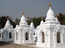
- Kuthodaw Pagoda (The World's Biggest Book): Built by King Mindon in 1857, this pagoda modeled on the Shwezigon Pagoda at Nyaung-U, is surrounded by 729 upright stone slabs on which are inscribed the entire Tipiṭaka as edited and approved by the Fifth Buddhist council. It is popularly known as "World's largest book" for its stone scriptures.
- Kyauktawgyi Pagoda: Near the southern approach to Mandalay Hill stands the Kyauktawgyi Buddha image built by King Mindon in 1853–78. The Image was carved out of a huge single block of marble. Statues of 80 arahants are assembled around the Image, twenty on each side. The carving was completed in 1865.
- Mahamuni Buddha Temple: The image of Gautama Buddha at Mahamuni Buddha Temple is said to have been cast in the life-time of the Gautama Buddha and that the Buddha embraced it seven times, thereby bringing it to life. Consequently, devout Buddhists hold it to be alive and refer to it as the Mahamuni Sacred Living Image. Revered as the holiest pagoda in Mandalay, It was built by King Bodawpaya in 1784. The image in a sitting posture is 12 feet and 7 inches (3.8 m) high. As the image was brought from Rakhine State, it was also called the Great Rakhine Buddha. The early morning ritual of washing the Face of Buddha Image draws a large crowd of devotees everyday. The Great Image is also considered as the greatest in Burma next to Shwedagon Pagoda. A visit to Mandalay is incomplete without a visit to Mahamuni Pagoda.
- Mandalay Hill: The hill has for long been a holy mount. Legend has it that the Buddha, on his visit, had prophesied that a great city would be founded at its foot. Mandalay Hill, 230 metres in elevation, commands a magnificent view of the city and surrounding countryside. The construction of a motor road to reach the hill-top has already been finished.
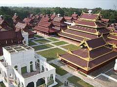
- Mandalay Palace: The whole magnificent palace complex was destroyed by a fire during World War II. However, the finely built palace walls, the city gates with their crowning wooden pavilions and the surrounding moat still represent an impressive scene of the Mandalay Palace, "Mya-nan-san-kyaw Shwenandaw", which has been rebuilt using forced labor. A model of the Mandalay Palace, Nanmyint-saung and Mandalay Cultural Museum are located inside the Palace grounds.
- Shwenandaw Monastery: Famous for its intricate wood carvings, this monastery is a fragile reminder of the old Mandalay Palace. Actually, it was a part of the old palace later moved to its current site by King Thibaw in 1880.
- The Chinese Temple of Mandalay: The Chinese Temple, well known for its old artistic architectures and cultural artifacts, reflects Mandalay's old history.
- Yadanabon Zoological Gardens: A small zoo between the Mandalay Palace and Mandalay Hill. It has over 300 species and is notably the only zoo to have Burmese roofed turtles.
Administration
The Mandalay City Development Committee (MCDC) is the city government. The Mandalay District consists of seven townships.
- Amarapura
- Aungmyethazan
- Chanayethazan (city centre)
- Chanmyathazi
- Maha Aungmye
- Patheingyi
- Pyigyidagun
Transport
Mandalay's strategic location in Central Burma makes it an important hub for transport of people and goods. The city is connected to other parts of the country and to China and India by multiple modes of transportation.
Air

Mandalay International Airport (MDL) is one of the largest and most modern airports in Myanmar. Built at a cost of US$150 million in 2000, it is highly underused; it serves mostly domestic flights with the exception of those to Kunming and to/from Bangkok and Chiang Mai, with daily flights on Air Asia and Bangkok Airways.[31] The airport has come to represent the military regime's propensity for bad planning and penchant for white elephant projects.[32] Myanmar recent opening stance on tourism means the airport is now receiving a growing number of visitors from Bangkok and Chiang Mai.
The airport is far from the city, 45 km (28 mi) on a modern highway. It costs US$8 to central Mandalay, US$6 from central Mandalay, and US$30 to/from Pyin U Lwin. Collective minibuses to Mandalay are US$5 each (stops where required).
River
The Ayeyarwady River remains an important arterial route for transporting goods such as farm produce including rice, beans and pulses, cooking oil, pottery, bamboo and teak.
Rail
Mandalay Central Railway Station is the terminus of Myanmar Railways's main rail line from Yangon and the starting point of branch lines to Pyin U Lwin (Maymyo), Lashio, Monywa, Pakokku, Kalay, Gangaw, and to the north, Shwebo, Kawlin, Naba, Kanbalu, Mohnyin, Hopin, Mogaung and Myitkyina.
Mandalay does not have an intra-city metro rail system. The former electric tramway has been decommissioned.
Roads
Mandalay literally is at the center of Burma's road network. The highway network includes roads towards:[33]
- Upper Burma and China—Mandalay–Tagaung–Bhamo–Myitkyina Road, Mandalay–Mogok–SiU–Bhamo Road, Mandalay–Lashio–Muse Road (part of Asian Highway route 14 or AH14)[34]
- Western Burma and India—Mandalay–Sagaing–Monywa–Kalewa–Tamu Road[34]
- Lower Burma– Yangon-Mandalay Expressway and AH1[34]
Most stretches of these highways are one-lane roads in poor condition.
Buses and cars
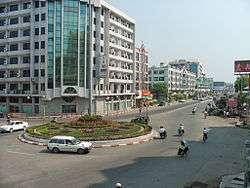
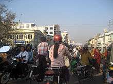
As the government allows only a few thousands of vehicles to be imported each year, motor transportation in Burma is highly expensive for most of its citizens.[35] Most people rely on bicycles, motorcycles and/or private and public buses to get around. The most popular car in Mandalay is the 1982/83 Nissan Sunny pickup truck. Because of its utility as a private bus or taxi, the two-and-a-half-decade old model still had strong demand and heady prices to match—from K10 million to K14 million (US$8,000 to US$11,000) in mid-2008.[36] To get around severe import limits, people of Mandalay have turned to illegally imported and hence unregistered (called "without" in Burmese English) motorcycles and cars despite the government's periodic confiscation sprees. (The number of domestically made cars remains negligible. Mandalay's small car makers produced i.e. assembled only about 3000 cars in 2007.)[37]
In March 2008, Mandalay had nearly 81,000 registered motor vehicles[38] plus an unknown number of unregistered vehicles. Although the number of cars in a city of one million is low, traffic in Mandalay is highly chaotic as thousands of bicycles and (unregistered) motorbikes freely roam around all the lanes of the streets. Unlike in Yangon where motorbikes, cycle rickshaws and bicycles are prohibited from entering downtown and busy areas, in Mandalay it is anything goes. That many traffic lights in Mandalay do not work only adds to the chaos.
Demographics
| Historical population | ||
|---|---|---|
| Year | Pop. | ±% |
| 1950 | 167,000 | — |
| 1960 | 250,000 | +49.7% |
| 1970 | 374,000 | +49.6% |
| 1980 | 499,000 | +33.4% |
| 1990 | 636,000 | +27.5% |
| 2000 | 810,000 | +27.4% |
| 2007 | 961,000 | +18.6% |
| 2010 | 1,034,000 | +7.6% |
| [2] | ||
A 2007 estimate by the UN puts Mandalay's population at nearly 1 million. The city's population is projected to reach nearly 1.5 million by 2025.[2] While Mandalay has traditionally been the bastion of Bamar (Burman) culture and populace, the massive influx of ethnic Chinese in the last 20 years has effectively pushed the Bamar out of the city center.[5][6][39] The foreign-born Chinese can easily obtain Burmese citizenship cards on the black market.[6] Ludu Daw Amar of Mandalay, the revered writer and journalist who died in April 2008, had said it felt like "an undeclared colony of Yunnan".[40] Today, the percentage of Chinese, estimated at 40% to 50% of the city (with the Yunnanese forming an estimated 30% of Mandalay's population), is believed to nearly rival that of the Bamar.[41] A sizable community of Burmese Indians also resides in Mandalay.
Burmese is still the principal language of the city although Standard Chinese is increasingly heard in the city's commerce centers such as Chinatown and Zegyo Market. English is a distant third language, spoken only by the urban elite.
Culture

Mandalay is Burma's cultural and religious center of Buddhism, having numerous monasteries and more than 700 pagodas. At the foot of Mandalay Hill sits the world's official "Buddhist Bible", also known as the world's largest book, in Kuthodaw Pagoda. The styles of Mandalay Buddha Images and Buddha Statues were many since King Mandon, who was a devout Buddhist, and had filled Mandalay with them and through the years Mandalay Buddhist art became established as the pure art of Myanmar. There are 729 slabs of stone that together are inscribed with the entire Pāli canon, each housed in its own white stupa. The buildings inside the old Mandalay city walls, surrounded by a moat, which was repaired in recent times using prison labor, comprise the Mandalay Palace, mostly destroyed during World War II. İt is now replaced by a replica, Mandalay Prison and a military garrison, the headquarters of the Central Military Command.
Media
Much of the media in Mandalay – like elsewhere in Burma – comes from Yangon. The city's non-satellite TV programming comes from Yangon-based state-run TV Myanmar and military-run Myawaddy, both of which provide Burmese language news and entertainment. Since December 2006, MRTV-4, formerly a paid channel, has also been available in Mandalay.[42] Mandalay has two radio stations. Naypyidaw-based Myanmar Radio National Service is the national radio service and broadcasts mostly in Burmese (and in English during specific times.) Semi-state-run Mandalay City FM (87.9FM) is the Mandalay metropolitan area's pop culture oriented station.[43]
The military government, which controls all daily newspapers in Burma, uses Mandalay to publish and distribute its three national newspapers, the Burmese language Myanmar Alin and Kyemon and the English language New Light of Myanmar.[44] The state-run Yadanabon is published in Mandalay and serves the Upper Burma market.[45] The Mandalay Daily newspaper is published by Mandalay City Development Committee since 1997 November 30.[46]
Sports

Mandalay's sporting facilities are quite poor by international standards but are still the best in Upper Burma. The 17,000 seat Bahtoo Stadium is largest in Upper Burma and hosts mainly local and regional association football and track-and-field tournaments. Since May 2009, professional football has arrived in Mandalay, with Yadanabon FC representing the city in the newly formed Myanmar National League, the country's first professional football league.[47]
Sport Climbing
At Waterfall Hill, the first bolted rock climbing site in Myanmar have been developed with the help of Mandalay climbers led by Steve, Tylor and Technical Climbing Club of Myanmar since 2010. [48] [49] [50]
Economy
Mandalay is the major trading and communications center for northern and central Burma. Much of Burmese external trade to China and India goes through Mandalay.
Among the leading traditional industries are silk weaving, tapestry, jade cutting and polishing, stone and wood carving, making marble and bronze Buddha images, temple ornaments and paraphernalia, the working of gold leaves and of silver, the manufacture of matches, brewing and distilling.
Chinese immigrants have increasingly dominated Mandalay's economy since the imposition of sanctions by the United States and the European Union in the 1990s.
Education
Mandalay has the best educational facilities and institutions, after Yangon, in Burma where state spending on education is among the lowest in the world.[51] Students in poor districts routinely drop out in middle school as schools have to rely on forced "donations" and various fees from parents for nearly everything – school maintenance to teachers' salaries.[52] Many wealthy Mandalay parents enroll their children in the city's English language private schools for primary and secondary education and Chinese and Singaporean universities for university education. Some wealthy Chinese families also send their children to "cram schools" where students study for entrance exams into Chinese universities from 6am to 8am, then to government high schools from 9am to 3pm, and finally preparation classes for Singapore GCE O levels from 4pm to 9pm.[53]
For the rest of the students who cannot afford to go abroad for studies, Mandalay offers Upper Burma's best institutions of higher education. The city's University of Medicine, Mandalay, University of Dental Medicine, Mandalay, Mandalay Technological University and University of Computer Studies, Mandalay are among the nation's most selective universities. The vast majority of university students in Mandalay attend liberal arts universities: Mandalay University, the oldest university in Upper Burma, and Yadanabon University.
Health care
The general state of health care in Burma is poor. The military government spends anywhere from 0.5% to 3% of the country's GDP on health care, consistently ranking among the lowest in the world.[54][55] In 2005, the public health care system of Mandalay Region with over 7.6 million people consisted of slightly over 1000 doctors and about 2000 nurses working in 44 hospitals and 44 health clinics. Over 30 of the so-called hospitals had less than 100 beds.[33] Although health care is nominally free, in reality, patients have to pay for medicine and treatment, even in public clinics and hospitals. Public hospitals lack many of the basic facilities and equipment.
Nonetheless Mandalay remains the main health care center for Upper Burma[56] as almost all of large public hospitals and private hospitals are in Mandalay. The city has ten public hospitals and one hospital specializing in traditional Burmese medicine. For a semblance of adequate health care, the well-to-do from Upper Burma go to private hospitals and clinics in Mandalay. For more advanced treatments, they have to go to Yangon or abroad. The wealthy Burmese routinely go abroad (usually Bangkok or Singapore) for treatment.[57]
Twin towns – Sister cities
Mandalay is twinned with:
-
 Cirebon, Indonesia
 -
 Kunming, China
 -
 Phnom Penh, Cambodia
Mandalay in popular culture
Rudyard Kipling wrote a poem called "Mandalay" (1890), which is the origin of the phrase "on the road to Mandalay".[58] In 1907, the poem was set to music by Oley Speaks as "On the Road to Mandalay". Speaks' version was widely recorded. Among the best known renditions is the one by Frank Sinatra on Come Fly With Me.
George Orwell was stationed at Mandalay for a time while working for the Indian Imperial Police in Burma, and his first novel, Burmese Days (1934), was based on his experiences in Burma. He also wrote a number of short non-fiction essays and short stories about Burma, such as "A Hanging" (1931) and "Shooting an Elephant" (1936). John Masters wrote a book about his wartime experiences in Burma called The Road Past Mandalay (1961).
Gallery
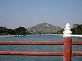 Mandalay Hill
 Mandalay Hill
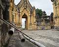 Maha aung mye bon zhan monastery in Inwa
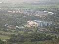 A view from Mandalay Hill
 Another view from Mandalay Hill
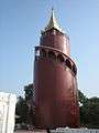 Mandalay Palace Watch Tower
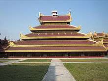 The Hluttaw Hall inside Mandalay Palace
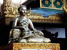
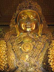 Mahamuni Buddha, A Rakhine masterpiece
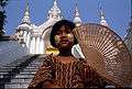 A Mandalay girl
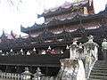 Shwe Kyaung, a famous monastery
- The Atumashi Monastery
 View from Sutaunppyei Pagoda in the Mandalay Hill
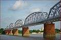 Now defunct old Sagaing Bridge
References
- ↑ "Water Purification Plant No. 8 in Aungmyethazan Township 60% Coomplete". Bi-Weekly Eleven (in Burmese). Eleven Media Group. 28 April 2011.
- 1 2 3 "United Nations World Urbanization Prospects, 2007 revision". The United Nations Population Division. Archived from the original on 18 December 2008. Retrieved 24 January 2009.
- 1 2 3 4 Zon Pann Pwint, Minh Zaw and Khin Su Wai (18–24 May 2009). "Mandalay marks 150th birthday". The Myanmar Times.
- ↑ "Myanmar Area Codes".
- 1 2 China's Ambitions in Myanmar (July 2000). "China's Ambitions in Myanmar". IISS Strategic Comments.
- 1 2 3 4 Stephen Mansfield (13 May 1999). "Myanmar's Chinese connection". Japan Times.
- ↑ Issac Taylor (1898). Names and Their Histories: A Handbook of Historical Geography and Topographical Nomenclature (2nd ed.). Rivingtons. p. 186.
- ↑ ဦးဟုတ်စိန်. "Entry for ratana". ပါဠိမြန်မာ အဘိဓာန် (Pāḷi-Myanmar Dictionary) (in Burmese). Pali Canon E-Dictionary Version 1.94. Retrieved 15 February 2015.
- ↑ ဦးဟုတ်စိန်. "Entry for pūra". ပါဠိမြန်မာ အဘိဓာန် (Pāḷi-Myanmar Dictionary) (in Burmese). Pali Canon E-Dictionary Version 1.94. Retrieved 15 February 2015.
- 1 2 "Mandalay Palace" (PDF). Directorate of Archaeological Survey, Burma. 1963. Retrieved 22 August 2006.
- 1 2 Kyaw Thein (1996). The Management of Secondary Cities in south-east Asia. Case Study: Mandalay. United Nations Centre for Human Settlements. UN-Habitat. ISBN 9789211313130.
- ↑ Vincent Clarence Scott O'Connor (1907). Mandalay: And Other Cities of the Past in Burma. Hutchinson & Co. pp. 6–9.
- ↑ Herbert Thirkell White (1913). A Civil Servant in Burma. London: E. Arnold.
- ↑ Ko Yin Aung (23 December 1999). "Prospects of Education in Myanmar". The New Light of Myanmar.
- ↑ Bird, George W (1897). Wanderings in Burma. London: F J Bright & Son. p. 254.
- ↑ The Axis Conquers the Philippines: January 1942-July 1942
- ↑ World War II net
- ↑ Jackson, Ashley (May 10, 2006). The British Empire and the Second World War. Bloomsbury Academic. p. 41.
- ↑ "Mandalay Centenary Stamps". eBay. Retrieved 25 January 2009.
- ↑ "23,000 Homeless in Burma Fire". New York Times via Reuters. 26 March 1984. Retrieved 25 January 2009.
- ↑ "Myanmar Fire Mar 1984 UNDRO Information Reports 1 – 2". ReliefWeb. 27 March 1984. Retrieved 25 January 2009.
- ↑ "Huge fire rages major market in Myanmar second largest city". China View via Xinhua. 25 February 2008. Retrieved 25 January 2009.
- ↑ Ne Nwe Moe Aung and Sithu Naing (2 March 2009). "Dry weather brings upsurge in outbreaks of fire in Myanmar". The Myanmar Times.
- 1 2 Min Lwin (April 2009). "The Chinese Road to Mandalay". The Irrawaddy.
- 1 2 Poon Kim Shee (2002). "The Political Economy of China–Myanmar Relations: Strategic and Economic Dimensions" (PDF). Ritsumeikan Annual Review of International Studies. Ritsumeikan University.
- ↑ Larkin 2006, p. 12.
- ↑ Christophe Vigny; et al. "Present-day crustal deformation around Sagaing fault, Myanmar" (PDF). Journal of Geophysical Research, vol 108, 19 November 2003. pp. 2–4. Retrieved 25 January 2009.
- 1 2 "Station Mandalay" (in French). Meteo Climat. Retrieved 11 June 2016.
- ↑ "World Weather Information Service – Mandalay". World Meteorological Organization. Retrieved 23 February 2013.
- ↑ Cappelen, John; Jensen, Jens. "Myanmar – Mandalay" (PDF). Climate Data for Selected Stations (1931–1960) (in Danish). Danish Meteorological Institute. p. 188. Archived from the original (PDF) on 27 April 2013. Retrieved 23 February 2013.
- ↑ http://www.bangkokair.com/eng/pages/view/flight-schedule
- ↑ Maung Maung Oo (26 November 2001). "Junta's New White Elephant Project is Paying Off". The Irrawaddy.
- 1 2 Thiha Aung (13 February 2005). "Mandalay Division marching to new golden land of unity and amity". New Light of Myanmar.
- 1 2 3 "Asian Highway in Myanmar" (PDF). unescap.org. Retrieved 12 January 2009.
- ↑ "Burmese Economy Is an Obstacle to Aid". New York Times. 29 May 2008.
- ↑ Phyo Wai Kyaw (2 June 2008). "Sunny pick-ups turn back the clock on Mandalay's roads". Myanmar Times.
- ↑ Phyo Wai Kyaw (30 July 2007). "Domestic autos take over Mandalay streets". Myanmar Times.
- ↑ Shwe Yinn Mar Oo (2 June 2008). "Motor vehicles in Myanmar". Myanmar Times.
- ↑ Forbes, Andrew ; Henley, David (2011). Traders of the Golden Triangle. Chiang Mai: Cognoscenti Books. ASIN: B006GMID5
- ↑ "Ludu Daw Amar: Speaking Truth to Power by Min Zin". The Irrawaddy, October 2002. Retrieved 12 January 2009.
- ↑ Rieffel, Lex (2010). Myanmar/Burma: inside challenges, outside interests. Brookings Institution Press. pp. 95–97. ISBN 978-0-8157-0505-5.
- ↑ "Myanmar to launch 2nd FM radio station in northern city". People's Daily Online via Xinhua. 20 March 2008.
- ↑ Kyaw Zin Htun and Soe Than Linn (24 March 2008). "Mandalay gets FM station". Myanmar Times.
- ↑ "Mandalay Media". Myanmar's Net. Retrieved 24 December 2008.
- ↑ "Naypyidaw to Launch New Daily". Irrawaddy . 23 December 2008.
- ↑ "Mandalay Daily Newspaper". Mandalay City Development Committee. 30 November 1997.
- ↑ Han Oo Khin (9–15 March 2009). "New era for football". The Myanmar Times. Archived from the original on 15 February 2012.
- ↑ https://www.facebook.com/climbmyanmar/?ref=ts&fref=ts
- ↑ http://goldenlandproject-blog.tumblr.com/page/4
- ↑ https://www.mountainproject.com/v/mandalay/110276403
- ↑ "HRDU Yearbook 2006 Chapter 9: Rights to Education and Health". Human Rights Documentation Unit. Retrieved 2008-09-14.
- ↑ Yee May Aung (10 September 2008). "Educationalists concerned by Burmese literacy rate". DVB.
- ↑ Sandra Davie (13 October 2008). "I see no future for my two sons in Myanmar.". Straits Times.
- ↑ "PPI: Almost Half of All World Health Spending is in the United States". 17 January 2007.
- ↑ Yasmin Anwar (28 June 2007). 06.28.2007 "Burma junta faulted for rampant diseases" Check
|url=value (help). UC Berkeley News. - ↑ Aye Lei Tun (11 June 2007). "Mandalay continues to play vital role as healthcare centre for the upper north". Myanmar Times.
- ↑ Thein Win Nyo (11 June 2007). "Medical tourism gives patients options". Myanmar Times.
- ↑ http://raysweb.net/poems/mandalay/index.html
Bibliography
- Larkin, Emma (6 March 2006). Finding George Orwell in Burma. Penguin Publishing Group. ISBN 978-1-101-11812-2.
External links
| Wikimedia Commons has media related to Mandalay. |
-
 Mandalay travel guide from Wikivoyage
 - See also nearby Pyin Oo Lwin, the historic hill station above Mandalay
- "Mandalay in 1885–1888 – the letters of James Alfred Colbeck" (PDF). (107 KiB) SOAS
- Mandalay Gallery with antique, colonial views of Mandalay
- Mandalay, the Burmese Heartland by Dr. Constance Wilson, Northern Illinois University
- Asian Historical Architecture – Mandalay by Prof. Robert D. Fiala, Concordia University, Nebraska
- Mandalay Centenary Song by Than Myat Soe MRTV3
| Mandalay | ||
| Preceded by Amarapura |
Capital of Burma 23 May 1859 – 29 November 1885 |
Succeeded by Yangon |
Capital: Mandalay | |
|
Capital: Mandalay | ||
| Kyaukse District |   | |
| Mandalay District | ||
| Meiktila District | ||
| Myingyan District | ||
| Nyaung-U District |
| |
| Pyinoolwin District |
| |
| Yamethin District | ||
| Main cities and towns | ||
| States | ||
|---|---|---|
| Regions | ||
| Self-Administered Zones | ||
| Self-Administered Divisions | ||
| Union Territories | ||