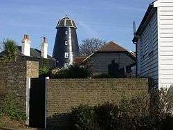
Oare Windmill
| Oare Windmill | |
|---|---|
|
The house converted mill | |
| Origin | |
| Grid reference | TR 009 625 |
| Year built | Late eighteenth or early nineteenth century |
| Information | |
| Purpose | Corn mill |
| Type | Tower mill |
| Storeys | Five storeys |
| Number of sails | Four |
| Type of sails | Patent sails |
| Windshaft | Cast iron |
| Winding | Fantail |
| Number of pairs of millstones | Four pairs |
Oare Mill is a Grade II* listed[1] house converted Tower mill in Oare, Kent, England that was built in the late eighteenth or early nineteenth century.
History
Oare mill was built in the late eighteenth or early nineteenth century. It was marked on the 1819-42 Ordnance Survey map and Greenwood's map of 1821. The mill was working until June 1919. There was a steam engine, the boiler of which once exploded and damaged the Mill Cottages and Windmill Inn.[2] Photographs show that the cap was still on the mill in 1952, but the roof had gone by 1963. In that year the derelict mill was converted into a house, retaining some machinery. A new domed polygonal roof fitted to replace the original cap.[3]
Description
Oare Mill is a five-storey tower mill with a stage at first-floor level. It formerly had four single patent sails carried on a cast-iron windshaft,[4] and a Kentish-style cap.[2] The cap was the largest on any mill in Kent, measuring 17 feet (5.18 m) by 14 feet (4.27 m) in plan and 9 feet 9 inches (2.97 m) high.[3] The mill was winded by a fantail. It drove four pairs of millstones[2] overdrift.[3] The wallower remains, mounted at the top of the Upright Shaft, which is wooden and 18 inches (460 mm) square. The Great Spur Wheel also remains.[3]
Millers
- Elliott - 1819
- Thomas K Hope
- Robert Shrubsole
- Kennett 1841
- F Inge
- H W Elliott 1862
- Thomas K Hope 1878
- B Filmer
- Herbert Filmer 1882 - 1886
- F Ralph 1891
- Herbert Filmer Sep 1917 - Jun 1919
References for above:-[2][3][5]
See also
 Windmills in Kent – Wikipedia book
References
- ↑ "OARE WINDMILL, OARE ROAD (east side), FAVERSHAM, SWALE, KENT". English Heritage. Retrieved 2008-04-18.
- 1 2 3 4 Coles Finch, William (1933). Watermills and Windmills. London: C W Daniel Company. pp. 253–54.
- 1 2 3 4 5 West, Jenny (1973). The Windmills of Kent. London: Charles Skilton Ltd. pp. 61–62. ISBN 0-284-98534-1.
- ↑ Photo dated 1940 by D W Muggeridge in the care of the Mills Archive Trust shows the windshaft to be cast iron
- ↑ "Directory of Kent Mill People". The Mills Archive Trust. Archived from the original on April 16, 2009. Retrieved 2008-04-18.
External links
- Windmill World page on the mill.
Coordinates: 51°19′35″N 0°52′57″E / 51.32639°N 0.88250°E
