Odderøya

Odderøya is an island off Kristiansand, Norway, connected to the mainland by bridges south of the city. The island creates a natural division between the eastern and western port of Kristiansand. The canal Gravanekanalen separates Odderøya from the city center and Fiskebrygga (the fish market), but four bridges ensure that the island is easily accessible. The island is mostly undeveloped, but the town development plan includes an area to allow for up to 500 homes.[1][2]
History
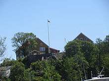
There are signs of ancient human activity on Odderøya. In Bendiksbukta there have been found a dagger, an ax and other tools of flint dating back to the stone age.[3] On Odderøya are many interesting traces of military activity.[1][4] Within this defined geographic area are military fortifications from the Great Northern War to the end of the Cold War. Key tracks from the battle of 9 April 1940 (Operation Weserübung) are partially visible.[5][6] There has been military activity on Odderøya from 1667 until 1999, when the fortress was phased out. The quarantine station or lazaretto at Odderøya[1] was the largest in Northern Europe and was in operation from 1804 to 1914. In 1804, it was a quarantine station for Denmark-Norway and Holstein.[7] The quarantine station was for ships where plague (disease) had spread aboard the ship. In connection with quarantine operations, the island also began to need its own cemetery, nicknamed the Cholera Cemetery. It is located at Kjerregårdsbukta. The quarantine station was separated from the rest of the island with a high wall that runs from the height of the hospital ("Lazaretto height") to Bendiksbukta. It was built in the years 1800 to 1807 and is under restoration.
At times, Odderøya has been closed to the public due to military activity. There are a large number of former gun emplacements around the island from varying periods of time for cannons, machine guns and mortars. Since the site has been available, the island has been a popular excursion and hiking area. Odderøya was opened to the public 23 June 1992 after the Odderøya fort was abandoned. This latest closure had lasted 52 years.
World War II
At 9 April 1940 eight Norwegian soldiers lost their lives in the battle against German aircraft and warships during the invasion of Norway in Operation Weserübung at Odderøya Fortress. The fortress returned the cannon fire from the German warships and attacks by Luftwaffe bombers.The attack against Kristiansand and Arendal consisted of the light cruiser Karlsruhe, three torpedo boats, and seven smaller vessels, one mothership and around 1,000 soldiers. Three times between 05 a.m. and 07 a.m. the German forces tried to penetrate and to put troops ashore, but whenever they chose to turn because of shelling from Odderøya. One of the grenades from Karlsruhe missed the fortress. By accident this grenade hit the upper part of Kristiansand Cathedral's church tower. In addition to the grenade hits at the fortress, a bombshell led to an explosion at the ammunition depot. At ten o'clock the commander at the cruiser decided to break through whatever the resistance would be. Meanwhile, defenders at Odderøya got a confusing message about not firing on British or French warships. When the German force attacked again, one of the signal flags was confused with a French flag, and therefore the fire from the fortress was withheld. When the force was landed, it met no resistance, and the Norwegian commander surrendered the fortress.[5] One of the anchors of the German merchant ship MS Seattle (1928) is exhibited by the Western battery of the fortress. During the battle the ship came under crossfire, was shot in fire and sank.[6]
The coordinated invasion of several cities started the former neutral Norway's participation in World War II on the Allied side.[8]
There is a memorial of the fallen soldiers at the abandoned fort on top of the island.
German military forces held the fort until the capitulation in 1945.[9]
Post-war
In much of the post-war period Odderøya fort served as a base and boot camp for the Coastal Artillery.[10] There is now a dedicated conservation plan for the many important objects of culture historical interest on the island.[11]
Following the takeover of the municipality of Kristiansand, Odderøya has been used for varying cultural purposes and there has been broad agreement that the eastern and southern part will remain as untouched as possible. The quayside on the island's west side, however is under construction and will become residential area, intersected by new, artificial canals.[12]
East side of Odderøya
On the island's east side[1] was an important port and cargo space even before the settlements in the area had been named Kristiansand and was founded as a city. The site was suitable for loading lumber that could be floated on the river Torridalselva (Otra) and then loaded aboard a vessel for further transportation.[13] The Quarantine Wall, the wall that had been built to separate the local population from patients who were affected by diseases is still visible and has been restored. On the east side, there are rocks and beaches suitable for swimming spots, including “the cholera beach” and Bendiksbukta.[1]
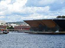
Silokaia and Kilden Performing Arts Centre on the west side
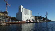
On the west side, there are a quay harbor, warehouses, a grain and cement silo and cleaning and tank farms. The port facilities, that in the summer are used mostly as a port for cruise ships, are part of the Kristiansand harbor. Grain Silo on pier 13 is designed by Sverre Aasland and Arne Korsmo for Christiansands Mills and is characterized as an "outstanding, independent and architectural work completed," and was awarded funds Houen diploma in 1939. The new Kilden Performing Arts Centre is built next door and was opened in 2012.[1] Beside the parking garage behind Kilden, a staircase leads further up the island. The quayside is under construction to be transformed into a residential area. [12]
South of the harbor is Odderøya at its steepest. There is a strolling route down to Odderøya Lighthouse from the western battery. On the way there, it oozes out odor that is not particularly good, because the city's sewage treatment plant is located in a tunnel into the rock under your feet. It is also a staircase up and down from the lighthouse to the southern part of Odderøya. Strolling around these stairs is at your own risk, due to danger of rock fall.[1]
Voluntary work and local conservation debate
After the island was abandoned as a military area, it has to some extent been a local debate about the use of the island in the future. There has been general agreement that the island's main older cultural heritage must be preserved. However, there has been a vigorous debate about the construction of roads, apartment buildings and commercial buildings, especially on the western side of the island. How much of the buildings from the former fort should be preserved, what can be demolished and replaced with more modern and beneficial buildings?[14]
Many of the citizens have become involved in voluntary conservation work. Odderøyas Venner is a voluntary association which organizes volunteer work[15] and operates the cafè at the former watchman's residence on the southern tip of the island, offering refreshments on Sundays all year long at 11 am to 4 pm.[1][16]
Culture and tourism
Odderøya is trying to establish itself as a regional cultural center. After the military activities were moved out, artists, galleries and filmmakers were established in the old barracks. Graphical printing on Odderøya is produced by renowned contemporary artists. The press in use was imported from Paris, and has been used by, among others, Pablo Picasso and Edvard Munch. In the marina Nodevika, a maritime museum with a museums marina are to be completed in 2015.[17]
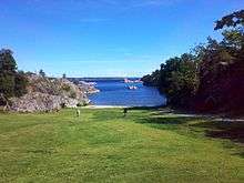
Many viewpoints offer a wonderful view over the bay and the entrance to the city.[1] There are roe deer on the island, and a pond named Salamander Pond; there is also other wildlife. Near the island's highest point (92 metres (302 ft) above sea level) is also a former bear's den (last inhabited by bears in the 1700s). From the top of the island there are outstanding views of the Kristiansandsfjord, islands like Dvergsøya and Flekkerøy and the lighthouses Oksøy and Grønningen. Odderøya offers opportunities for recreation, walking in the woods, swimming and fishing from the rocks, despite the proximity to the city.[18]
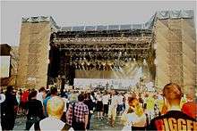
Concert venue
Parts of the Quart festival in 1992–2009 added Odderøya. Later, Odderøya has also been used as locations for live concerts.,[19] There have been concerts in Bendiksbukta, on the lawn, Odden, a rebuilt sports ground,[1] and a club in Odderøyhallen. In 2007, the sports ground was rebuilt with a new concert venue with an outdoor amphitheater, Odderøya Amphi, that has an audience capacity of 22,000.
On stage on Odderøya
Many different kinds of bands and musicians have given outdoors live concerts on Odderøya over the years, including David Bowie, Bryan Adams, Nick Cave, Alice Cooper, Ozzy Osbourne, John Fogerty, Bob Dylan, Sting, Kanye West, No Doubt, Foo Fighters, Daft Punk, Björk, Alicia Keys, Black Eyed Peas, Damian Marley, Backstreet Boys, Pink, Slash, Oasis, Snoop Dogg, 50 Cent, Ron Wood, The Who, Muse and Coldplay.[20][21]
Gallery
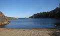 Beach and islets (Bendiksbukta)
 Lonely small beach at Odderøya
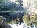 A pond at Odderøya
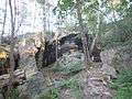 Caves at Odderøya
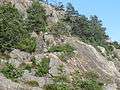 Steep cliffs and stairs. western Odderøya
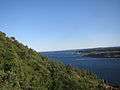 Hillside facing west at Odderøya
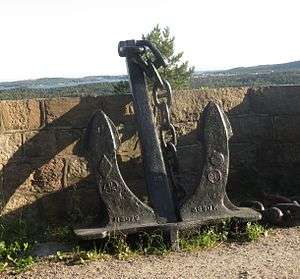 An anchor from MS Seattle
Cannons
 Cannons from the 17th century, the oldest on Odderøya
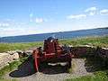 Cannon from the early 19th century, at the south of Odderøya
 Fixed cannon from World War II
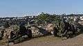 Field guns, intended for salute
From the quarantine station
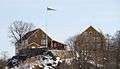 "The lazaretto height" (Winter photography)
 The previous lazaretto buildings
 The quarantine wall I
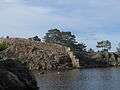 The quarantine wall II
See also
References
- 1 2 3 4 5 6 7 8 9 10 Map and description in Norwegian & English
- ↑ Odderøya at www.visitnorway.com (English)
- ↑ Kulturminnesøk: Bendiksbukta Norwegian Directorate for Cultural Heritage (Norwegian)
- ↑ Odderøya Fortress (English)
- 1 2 Odderøya 1940 - 1945 Vest-Agdermuseet (Norwegian)
- 1 2 Kampen om Kristiansand by German Rear Admiral Otto Schenk, Norwegian translation by Olav Ulltveit-Moe Arkivet Foundation
- ↑ Karantenestasjonen (Norwegian)
- ↑ Per Erik Olsen (ed):Norges kriger pp 385-391. Vega Forlag, Oslo 2011 (Norwegian) ISBN 978-82-8211-107-2
- ↑ KG4: Angrepet mot Kristiansand og Arendal Royal Norwegian Navy Museum (Norwegian)
- ↑ Kulturminneløypa (Odderøya) in Norwegian
- ↑ Landsverneplan, Odderøya (Norwegian)
- 1 2 Kanalbyen Port of Kristiansand (English)
- ↑ Climbing Odderøya (Optional languages)
- ↑ Arkitektens roller Odderøya Essay by Henrik Norbakk (Norwegian)
- ↑ Odderøyas venner (Norwegian)
- ↑ Odderøya Sunday Cafè (Norwegian)
- ↑ Aktivitetshuset I Nodeviga Vest-Agder-Museet (Norwegian)
- ↑ Trolley tour on Odderøya UT.no (Optional languages)
- ↑ Odderøya Live in Norwegian only
- ↑ Quartfestivalen, Archives National Archives of Norway (Norwegian)
- ↑ Concert schedules from 2012 - www.bandsintown.com
| Wikimedia Commons has media related to Odderøya. |
External links
- Nature, history, culture and recreation at Odderøya (Norwegian)
- The quarantine station at Odderøya DigitaltMuseum VIDEO (Norwegian)
- The German attack on Odderøya Fortress 9 April 1940 DigitaltMuseum VIDEO (Norwegian)
- Odderøya Fortress Agderkultur (Norwegian/English)
- Geocaching Odderøya Mellombatteriet (Norwegian/English)
Coordinates: 58°08′08″N 8°00′15″E / 58.13556°N 8.00417°E
| Before 20th century |  | |
|---|---|---|
| From 20th century |
| |