Odessa, Florida
| Odessa, Florida | |
|---|---|
| CDP | |
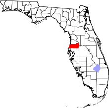
 Location in Pasco County and the state of Florida | |
| Coordinates: 28°11′0″N 82°34′6″W / 28.18333°N 82.56833°WCoordinates: 28°11′0″N 82°34′6″W / 28.18333°N 82.56833°W | |
| Country | United States |
| State | Florida |
| County | Hillsborough and Pasco |
| Area | |
| • Total | 5.6 sq mi (14.6 km2) |
| • Land | 5.3 sq mi (13.7 km2) |
| • Water | 0.3 sq mi (0.9 km2) |
| Elevation | 56 ft (17 m) |
| Population (2000) | |
| • Total | 3,173 |
| • Density | 566.6/sq mi (217.3/km2) |
| Time zone | Eastern (EST) (UTC-5) |
| • Summer (DST) | EDT (UTC-4) |
| FIPS code | 12-51100[1] |
| GNIS feature ID | 0288053[2] |
Odessa is a census-designated place (CDP) in Pasco County, Florida, United States. The population was 3,173 at the 2000 census and more than doubled to 7,267 in 2010.[3] Northwest of Tampa, Odessa had been an area of open spaces, ranching, and horse properties. More recently it has seen many suburban property developments as Tampa's population expands.
History
Odessa was founded in the 1880s by Peter Demens,[4] a Russian immigrant who established the community through the Orange Belt Railway.[5] Demens also founded St. Petersburg, Florida and named both communities after places he used to go to in his native country.
There was once a large sawmill in the area providing employment. This sawmill replaced some smaller ones and was burned in a fire in 1922.[4]
The area is rapidly being developed as Tampa expands.
Odessa was home to Tampa Bay Executive Airport until 2004.[6]
Geography
Odessa is located at 28°11′0″N 82°34′6″W / 28.18333°N 82.56833°W (28.183446, -82.568456).[7]
According to the United States Census Bureau, the Census Designated Place lies entirely in Pasco County, Florida, and has a total area of 5.6 square miles (15 km2) of which 5.3 square miles (14 km2) is land and 0.3 square miles (0.78 km2) (6.04%) is water.
The mailing area that uses the city of Odessa stretches into Hillsborough County and overlaps parts of Keystone, a separate CDP located entirely in Hillsborough County. This apparent overlap is due to USPS ZIP code designation only; the two CDPs do not actually overlap.[7]
Demographics
As of the census[1] of 2000, there were 3,173 people, 1,181 households, and 896 families residing in the CDP. The population density was 598.9 people per square mile (231.2/km²). There were 1,272 housing units at an average density of 240.1/sq mi (92.7/km²). The racial makeup of the CDP was 95.93% White, 0.66% African American, 0.57% Native American, 0.72% Asian, 0.03% Pacific Islander, 0.91% from other races, and 1.17% from two or more races. Hispanic or Latino of any race were 6.81% of the population.
There were 1,181 households out of which 35.1% had children under the age of 18 living with them, 62.8% were married couples living together, 8.6% had a female householder with no husband present, and 24.1% were non-families. 18.0% of all households were made up of individuals and 4.1% had someone living alone who was 65 years of age or older. The average household size was 2.69 and the average family size was 3.04.
In the CDP the population was spread out with 24.9% under the age of 18, 7.0% from 18 to 24, 32.1% from 25 to 44, 27.6% from 45 to 64, and 8.4% who were 65 years of age or older. The median age was 39 years. For every 100 females there were 108.3 males. For every 100 females age 18 and over, there were 104.8 males.
The median income for a household in the CDP was $45,864, and the median income for a family was $55,461. Males had a median income of $38,992 versus $26,818 for females. The per capita income for the CDP was $21,548. About 3.7% of families and 6.7% of the population were below the poverty line, including 10.4% of those under age 18 and 11.5% of those age 65 or over.
References
- 1 2 "American FactFinder". United States Census Bureau. Retrieved 2008-01-31.
- ↑ "US Board on Geographic Names". United States Geological Survey. 2007-10-25. Retrieved 2008-01-31.
- ↑ Odessa Census Viewer
- 1 2 History of Odessa, Florida (Fivay.org)
- ↑ History of Railroads in Pasco County Florida (Fivay.org)
- ↑ Tampa Bay Executive Airport (Abandoned & Little-Known Airfields)
- 1 2 "US Gazetteer files: 2010, 2000, and 1990". United States Census Bureau. 2011-02-12. Retrieved 2011-04-23.
External links
- Trinity and Odessa Florida Information
- History of Odessa
- Parry, Albert (Spring 1944). "US towns named Odessa". Russian Review. 3 (2): 36–40. doi:10.2307/125407.
