Odorhei County
| Odorhei | ||
|---|---|---|
| ||
 | ||
| Historic region | Transylvania | |
| Area | ||
| • Total | 2,977 km2 (1,149 sq mi) | |
| Population (1930) | ||
| • Total | 130,282 | |

Odorhei was a county (Romanian: județ) in the Kingdom of Romania. The county seat was Odorheiu Secuiesc.
Geography
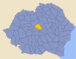
Odorhei County covered 2,977 km2 and was located in central part of Greater Romania, in Transylvania. Currently, the territory that comprised the greater part of Odorhei County is now part of Harghita County and Covasna County. In the interwar period, it neighbored Târnava-Mică County and Târnava-Mare County to the west, Mureș County to the north, Ciuc County to the east, and Brașov County and Trei-Scaune County to the south. Odorhei county was abolished in the administrative reforms of September 6, 1950.
Administrative organization
Administratively, Odorhei County was divided into four districts (plăși):
Population
According to the Romanian census of 1930 the population of Odorhei County was 130,282, of which 91.6% were ethnic Hungarians, 4.9% ethnic Romanians, 2.0% Romani, 1.0% Jews, and 0.4% Germans. Classified by religion: 37.4% were Reformed (Calivinist), 34.6% were Roman Catholic, 20.6% Unitarian, 3.7% Orthodox Christian, 1.1% Jewish, and 1.1% Greek-Catholic.
Urbanization
In 1930 the urban population of Odorhei County was 8,518, which included 81.3% Hungarians, 11.3% Romanians, 3.3% Jews, 2.0% Germans, and 1.4% Roma by ethnicity. The religious mix of the urban population was 51.3% Roman Catholic, 25.9% Reformed, 8.0% Eastern Orthodox, 5.3% Unitarian, 3.7% Jewish, 3.3% Greek-Catholic, and 1.9% Lutheran.
External links
| Wikimedia Commons has media related to Interwar Odorhei County. |
- (Romanian) Odorhei County on memoria.ro
