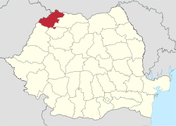
Satu Mare County
| Satu Mare County Județul Satu Mare | ||
|---|---|---|
| County | ||
| ||
 | ||
| Coordinates: 47°41′N 22°53′E / 47.69°N 22.89°ECoordinates: 47°41′N 22°53′E / 47.69°N 22.89°E | ||
| Country | Romania | |
| Development region | Nord-Vest | |
| Historical region | Crișana, Maramureș | |
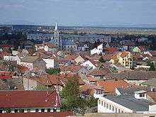
| Capital | Satu Mare | |
| Area | ||
| • Total | 4,418 km2 (1,706 sq mi) | |
| Area rank | 36th | |
| Population (2007)[1] | ||
| • Total | 366,270 | |
| • Rank | 31st | |
| • Density | 83/km2 (210/sq mi) | |
| Telephone code | (+40) 261 or (+40) 361[2] | |
| ISO 3166 code | RO-SM | |
| Website |
County Council Prefecture | |
Satu Mare County (Romanian: Județul Satu Mare, pronounced [ˌsatu ˈmare]) is a county (județ) of Romania on the border with Hungary and Ukraine. The capital city is Satu Mare. Besides Romanians (58.8% of the population), Satu Mare features a significant ethnic minority of Hungarians (35.2%).
Name
In Hungarian, it is known as Szatmár megye, in German as Kreis Sathmar, in Ukrainian as Сату-Маре, and in Slovak as Satmárska župa.
Demographics
Satu Mare is a multicultural city, with a population mix of Romanian, Hungarian, Roma, German and other ethnicities.
In 2002, Satu Mare County had a population of 367,281 and the population density was 83/km².[3][4]
- Romanians – 58.8%
- Hungarians – 35.2%
- Roma – 3.7%
- Germans – 1.7%
- Ukrainians, Slovaks, other
In 2011, its population was 329,079 and population density was 74.48/km².[3][5]
- Romanians – 57.73%
- Hungarians – 34.5%
- Roma – 5.32%
- Germans – 1.51%
- Rusyns, Ukrainians, Slovaks, other
Hungarians mostly reside along the border with Hungary, but some are also scattered throughout the whole county.
Historically, Hungarians were concentrated in the cities, where administration resides, while the Romanian population was larger in the villages throughout the county. In 1930 the Hungarians were representing 41,9% of the urban population in Satu Mare County and only 20,0% of the population in the villages according to census data.[6] The proportion of different ethnic groups varied throughout the history, due to regime and political changes. After the Austro-Hungarian Compromise of 1867 the Hungarian population increased its proportion greatly, in 1880 representing 44.4% and in 1910 reaching 55.1% of the county population, according to Árpád E. Varga.[7] After World War I the Hungarian and German population declined.
| Year | County population | Romanians | Hungarians | Germans |
|---|---|---|---|---|
| 1880[8] | 194,326 | 76,668 | 95,681 | 13,449 |
| 1890 | 216,158 | 85,663 | 114,836 | 14,030 |
| 1900 | 245,855 | 93,591 | 138,086 | 12,165 |
| 1910 | 267,310 | 92,264 | 166,369 | 6,709 |
| 1920 | 262,937 | 124,476 | 81,242 | 34,982 |
| 1930[6] | 294,875 | 178,523 | 74,191 | 9,530 |
| 1948[9] | 312,672 | |||
| 1956 | 337,531 | 180,930 | 145,880 | 3,588 |
| 1966 | 359,393 | |||
| 1977 | 393,840 | |||
| 1992 | 400,789 | |||
| 2002 | 367,281 | |||
| 2004 | 371,759 | |||
| 2007 | 366,270 |
Geography
This county has a total area of 4,418 square kilometres (1,706 sq mi).
In the north are the Oaș Mountains, part of the Eastern Carpathians. This makes up around 17% of the area. The remainder is hills, forming 20% of the area, and plains. The western county takes up the Eastern part of the Pannonian Plain.
The county is crossed by the Someș River and also Tur River and Crasna River.
The county lies partly in the historical region of Maramureș and partly in the historical region of Crișana.
Neighbours
- Maramureș County in the East.
- Hungary in the West – Szabolcs-Szatmár-Bereg County.
- Ukraine in the North – Zakarpattia Oblast.
- Bihor County and Sălaj County in the South.
It is a member of the Carpathian euroregion.
Economy
Satu Mare County benefits from its position, close to the border of Romania with Hungary and Ukraine, and it is one of the places which attracts foreign investment in industry and agriculture.
The predominant industries in the county are:
- Textiles industry.
- Machine and automotive components.
- Food industry.
- Wood and furniture industry.
Tourism
The main tourist attractions in the county are:
- The "Oaș Country", with its strong Romanian folk traditions, on the North Eastern side of the county.
- The Oaș Mountains.
- The cities of Satu Mare and Carei.
- Tășnad Resort.
- The fortifications from Ardud and Medieșu Aurit
Politics
The Satu Mare County Council, elected at the 2016 local government elections, is made up of 33 counselors, with the following party composition:[10]
| Party | Seats | Current Council | |||||||||||||
|---|---|---|---|---|---|---|---|---|---|---|---|---|---|---|---|
| Democratic Alliance of Hungarians | 13 | ||||||||||||||
| Social Democratic Party | 9 | ||||||||||||||
| National Liberal Party | 7 | ||||||||||||||
| Alliance of Liberals and Democrats | 4 | ||||||||||||||
Administrative divisions
Satu Mare County has 2 municipalities, 4 towns and 59 communes:
- Municipalities
- Towns
- Communes
- Acâș
- Agriș
- Andrid
- Apa
- Bătarci
- Beltiug
- Berveni
- Bixad
- Bârsău
- Bogdand
- Botiz
- Călinești-Oaș
- Cămărzana
- Cămin
- Căpleni
- Căuaș
- Cehal
- Certeze
- Ciumești
- Craidorolț
- Crucișor
- Culciu
- Doba
- Dorolț
- Foieni
- Gherța Mică
- Halmeu
- Hodod
- Homoroade
- Lazuri
- Medieșu Aurit
- Micula
- Moftin
- Odoreu
- Orașu Nou
- Păulești
- Petrești
- Pir
- Pișcolt
- Pomi
- Porumbești
- Racşa
- Sanislău
- Santău
- Săcășeni
- Săuca
- Socond
- Supur
- Tarna Mare
- Terebești
- Tiream
- Târșolț
- Turț
- Turulung
- Urziceni
- Valea Vinului
- Vetiș
- Viile Satu Mare
- Vama
References
| Wikivoyage has a travel guide for Maramureș. |
| Wikimedia Commons has media related to Satu Mare County. |
- ↑ INSSE Statistic
- ↑ The number used depends on the numbering system employed by the phone companies on the market.
- 1 2 National Institute of Statistics, "Populația după etnie"
- ↑
- ↑ Structura Etno-demografică a României
- 1 2 "Recensământul general al populației României din 29 Decemvrie 1930", vol. II, pag. 394, Institutul Central de Statistica, (published in French and Romanian)
- ↑ "Árpád E. Varga, Hungarians in Transylvania between 1870 and 1995, Original title: Erdély magyar népessége 1870–1995 között, Published in Magyar Kisebbség 3–4, 1998 (New series IV), pp. 331–407, Translation by Tamás Sályi, Linguistic editing by Rachel Orbell, Published by Teleki László Foundation. Budapest, March 1999"
- ↑ Erdély etnikai és felekezeti statisztikája
- ↑ National Institute of Statistics, "Populația la recensămintele din anii 1948, 1956, 1966, 1977, 1992 și 2002"
- ↑ "Mandate de CJ pe judete si competitori" (in Romanian). Biroul Electoral Central. 10 June 2016. Retrieved 16 June 2016.
