Ohio State Route 105
| ||||
|---|---|---|---|---|
 | ||||
| Route information | ||||
| Maintained by ODOT | ||||
| Length: | 28.26 mi[1] (45.48 km) | |||
| Existed: | 1923[2][3] – present | |||
| Major junctions | ||||
| West end: |
| |||
|
| ||||
| East end: |
| |||
| Location | ||||
| Counties: | Wood, Sandusky, Ottawa | |||
| Highway system | ||||
| ||||

State Route 105 (SR 105) is an east–west state highway in the northwestern portion of the U.S. state of Ohio. Its western terminus is at an interchange with Interstate 75 in Bowling Green that doubles as the southern terminus of State Route 64, and its eastern terminus is at State Route 19 in Oak Harbor. For its final 0.4 miles (0.64 km), the route overlaps State Route 163 which continues east.
History
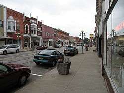
The eastern terminus of OH 105 is in Oak Harbor, where it intersects OH 19
SR 105 was commissioned in 1923, routed from 4 miles (6.4 km) east of Bowling Green to Oak Harbor along its current alignment. Its western terminus was at then SR 34, later became U.S. Route 6 (US 6).[2][3] The entire route was paved by 1934.[4][5] Between 1967 and 1969, extended west to current western terminus, along former US 6 alignment.[6][7]
Major intersections
| County | Location | mi | km | Destinations | Notes |
|---|---|---|---|---|---|
| Wood | Bowling Green | 0.00 | 0.00 | Exit 181 (I-75); southern terminus of SR 64 | |
| Scotch Ridge | 5.83 | 9.38 | |||
| Wood–Sandusky county line | Freedom–Woodville township line | 12.11 | 19.49 | ||
| Sandusky | Woodville Township | 14.46 | 23.27 | Eastern terminus of SR 582 | |
| Woodville | 15.16 | 24.40 | Western end of US 20 concurrency | ||
| 15.70 | 25.27 | Eastern end of US 20 concurrency | |||
| Ottawa | Harris Township | 19.88 | 31.99 | ||
| 24.11 | 38.80 | ||||
| Oak Harbor | 27.82 | 44.77 | Western end of SR 163 concurrency | ||
| 28.26 | 45.48 | Eastern end of SR 163 concurrency | |||
1.000 mi = 1.609 km; 1.000 km = 0.621 mi
| |||||
References
- ↑ Ohio Department of Transportation. "Technical Services Straight Line Diagrams". Retrieved April 30, 2010.
- 1 2 Ohio Department of Highways and Public Works (April 1922). Map of Ohio State Highways (MrSID) (Map). Columbus: Ohio Department of Highways and Public Works. Retrieved September 17, 2013.
- 1 2 Ohio Department of Highways and Public Works (July 1923). Map of Ohio Showing State Routes (MrSID) (Map). 1:760,320. Columbus: Ohio Department of Highways and Public Works. Retrieved September 17, 2013.
- ↑ Ohio Department of Highways (1933). Map of Ohio Showing State Routes (MrSID) (Map). 1:760,320. Columbus: Ohio Department of Highways. OCLC 5673562, 7237035, 837961470. Retrieved September 17, 2013.
- ↑ Ohio Department of Highways (1934). Map of Ohio Showing State Routes (MrSID) (Map). 1:760,320. Columbus: Ohio Department of Highways. OCLC 5673562, 7236991. Retrieved September 17, 2013.
- ↑ Ohio Department of Highways (1967). Official Highway Map of Ohio (MrSID) (Map). Columbus: Ohio Department of Highways. OCLC 5673562, 7444249. Retrieved September 17, 2013.
- ↑ Ohio Department of Highways (1969). Official Highway Map of Ohio (MrSID) (Map). Columbus: Ohio Department of Highways. OCLC 5673562, 7448779. Retrieved September 17, 2013.
External links
This article is issued from Wikipedia - version of the 11/30/2016. The text is available under the Creative Commons Attribution/Share Alike but additional terms may apply for the media files.