Ohio State Route 111
| ||||
|---|---|---|---|---|
 | ||||
| Route information | ||||
| Maintained by ODOT | ||||
| Length: | 31.49 mi[1] (50.68 km) | |||
| Existed: | 1923[2][3] – present | |||
| Major junctions | ||||
| West end: | Woodburn Road near Paulding | |||
|
| ||||
| East end: |
| |||
| Location | ||||
| Counties: | Paulding, Defiance | |||
| Highway system | ||||
| ||||

State Route 111 (SR 111) is a 31.49-mile (50.68 km) state route that runs between the Indiana state line and Defiance in the US state of Ohio. Most of the route is a rural two-lane highway and passes through both farmland and residential properties. For some of its path, SR 111 runs generally parallel to the north of the Auglaize River.
The highway was first signed in 1923 on much the same alignment as today. A few realignments of the route have happened; the first in 1927 removed a section of highway west of SR 49. This section was later extended due west of SR 49 to the Indiana state line. Another realignment happened in 1983 with the route heading north out of Paulding concurrent with U.S. Route 127 (US 127).
Route description
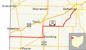
SR 111 heads north from Woodburn Road concurrent with State Line Road, passing through farmland as a two-lane highway. The road turns due east and heads away from the Indiana state line. The highway has an intersection with SR 49 in rural Paulding County. The route enters the village of Paulding and has an intersection with SR 500. After the intersection with SR 500 the route passes through a mix of residential and commercial properties. The route makes a sharp curve and heads north towards downtown Paulding. In downtown Paulding, the road has a traffic signal at US 127 and the two routes head north concurrent. The concurrency passes the Paulding County Court House and head north out of downtown Paulding. On the north side of the village the highway passes through mostly residential properties, with some commercial properties.[4][5][6]
The two highways leave Paulding and passes through farmland, with a few houses. North of Paulding, in rural Paulding County, SR 111 turns east towards Defiance, with US 127 still heading north. The highway heads east passing through farmland, with some houses. The route begins a concurrency with SR 637 west of Junction. The concurrency enters Junction and the concurrency ends with SR 637 heading east and SR 111 heading northeast. The highway leaves Junction heading northeast with the Auglaize River close to the south side of the roadway, resulting in that side of the highway becoming primarily wooded, while the northside of the highway remains bounded by farmland. The road enters Defiance on the southwest side of town, passing through residential properties. The highway passes under a set of CSX Railroad tracks and enters downtown Defiance. In downtown SR 111 ends at a traffic light with SR 15, SR 18 and SR 66.[4][5][6][7][8]
SR 111 is not part of the National Highway System, a system of routes important to the nation's economy, mobility and defense.[9][10] The highway is maintained by the Ohio Department of Transportation (ODOT). ODOT's 2009 annual average daily traffic (AADT) calculations showed that the lowest traffic levels were the 2,663 vehicles which used the highway daily on the section that is between the Indiana state line and SR 49; the peak traffic volumes were 12,220 vehicles AADT along a section of SR 111 near its eastern terminus, in downtown Defiance.[11][12]
History
SR 111 was first signed and paved in 1923 from the Indiana state line west of Payne to Defiance. The route from Indiana to Payne is now SR 613 and SR 111 was concurrent with SR 108, now SR 49, north of Payne.[2][3] In 1927 the route from Payne west became SR 113, leaving SR 111 only between SR 49 and Defiance.[13][14] The highway was extended to Indiana state line heading due west from SR 49 towards Indiana in 1935.[15][16] In 1983 the route was moved to its current route between Paulding and Defiance.[17][18] No significant changes have taken place to this state route since 1983.[5][18]
Major intersections
| County | Location | mi[1] | km | Destinations | Notes |
|---|---|---|---|---|---|
| Paulding | Harrison Township | 0.00 | 0.00 | Woodburn Road State Line Road | Western terminus of SR 111; Indiana state line |
| 4.67 | 7.52 | ||||
| Paulding | 11.50 | 18.51 | Eastern terminus of SR 500 | ||
| 12.43 | 20.00 | Southern end of US 127 concurrency | |||
| Crane Township | 16.37 | 26.34 | Northern end of US 127 concurrency | ||
| Junction | 21.96 | 35.34 | Western end of SR 637 concurrency | ||
| 23.40 | 37.66 | Eastern end of SR 637 concurrency | |||
| Defiance | Defiance | 31.49 | 50.68 | Eastern terminus of SR 111 | |
1.000 mi = 1.609 km; 1.000 km = 0.621 mi
| |||||
References
- 1 2 Ohio Department of Transportation. "Technical Services Straight Line Diagrams". Retrieved April 30, 2012.
- 1 2 Official Ohio Highway Map (Map). Cartography by ODOH. Ohio Department of Highways. 1922. Retrieved January 14, 2013.
- 1 2 Official Ohio Highway Map (Map). Cartography by ODOH. Ohio Department of Highways. 1923. Retrieved January 14, 2013.
- 1 2 Google (April 3, 2012). "Overview of SR 111 in Ohio" (Map). Google Maps. Google. Retrieved April 3, 2012.
- 1 2 3 Ohio Highway Map (PDF) (Map). Cartography by ODOT. Ohio Department of Transportation. 2011. § A4–B4. Retrieved January 14, 2013.
- 1 2 Map of Paulding County, Ohio (PDF) (Map). Cartography by ODOT. Ohio Department of Transportation. December 2008. Retrieved January 26, 2013.
- ↑ Map of Defiance County, Ohio (PDF) (Map). Cartography by ODOT. Ohio Department of Transportation. December 2008. Retrieved January 26, 2013.
- ↑ Ohio Rail Transportation Map (PDF) (Map). Cartography by ODOT. Ohio Department of Transportation. 2011. § C3. Retrieved January 15, 2013.
- ↑ National Highway System: Ohio (PDF) (Map). Federal Highway Administration. December 2003. Retrieved January 14, 2012.
- ↑ Natzke, Stefan; Neathery, Mike; Adderly, Kevin (September 26, 2012). "What is the National Highway System?". National Highway System. Federal Highway Administration. Retrieved January 14, 2012.
- ↑ Traffic Survey Report - Paulding County (PDF) (Map). Ohio Department of Transportation. 2009. Retrieved January 8, 2012.
- ↑ Traffic Survey Report - Defiance County (PDF) (Map). Ohio Department of Transportation. 2009. Retrieved January 8, 2012.
- ↑ Official Ohio Highway Map (Map). Cartography by ODOH. Ohio Department of Highways. 1926. Retrieved January 14, 2013.
- ↑ Official Ohio Highway Map (Map). Cartography by ODOH. Ohio Department of Highways. 1927. Retrieved January 14, 2013.
- ↑ Official Ohio Highway Map (Map). Cartography by ODOH. Ohio Department of Highways. 1934. Retrieved January 14, 2013.
- ↑ Official Ohio Highway Map (Map). Cartography by ODOH. Ohio Department of Highways. 1935. Retrieved January 14, 2013.
- ↑ Official Ohio Highway Map (Map). Cartography by ODOT. Ohio Department of Transportation. 1982. Retrieved January 14, 2013.
- 1 2 Official Ohio Highway Map (Map). Cartography by ODOT. Ohio Department of Transportation. 1983. Retrieved January 14, 2013.