Ohio State Route 201
| ||||
|---|---|---|---|---|
 | ||||
| Route information | ||||
| Maintained by ODOT | ||||
| Length: | 21.69 mi[1] (34.91 km) | |||
| Existed: | 1923[2][3] – present | |||
| Major junctions | ||||
| South end: |
| |||
|
| ||||
| North end: |
| |||
| Location | ||||
| Counties: | Miami, Montgomery | |||
| Highway system | ||||
| ||||

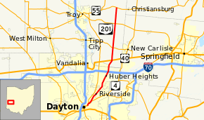
State Route 201 (SR 201) is a 21.69-mile (34.91 km) long north–south state highway in the western portion of the U.S. state of Ohio. The southern terminus of SR 201 is at an interchange with the SR 4 freeway in Dayton. Its northern terminus is at a T-intersection with SR 55 approximately 3.25 miles (5.23 km) east of Casstown.
Route description
Along its path, SR 201 passes through the eastern portion of Montgomery County and the eastern portion of Miami County. There are no segments of SR 201 that are included as a part of the National Highway System.[4]
SR 201 begins in Dayton, within the same interchange complex that also features the southern terminus of SR 202. Northbound SR 204 begins on a ramp from SR 4 to Troy Street and Valley Street. At the bottom of the ramp, SR 201 reaches Troy Street, also designated as SR 202. SR 201 travels east along Herman Street before turning north onto Valley Street. The southbound direction of SR 201, designated SR 201-D by the Ohio Department of Transportation, traveled south along Valley Street from the Herman Street intersection, intersected Troy Street (also the southern terminus of SR 202), then traveled north on Keowee Street before turning left onto the ramp to southbound SR 4 ending at the ramp's merge with the freeway.[1][5]
SR 201 follows Valley Street until the intersection with Brandt Street, and then follows Brandt Street northward toward Riverside. After entering Riverside, Brandt Street changes its name to Brandt Pike.[6] SR 201 continues as Brandt Pike (even as it again passes inside Dayton city limits) through Huber Heights until it reaches the unincorporated community of Brandt in Bethel Township, Miami County. From there it loses its alternative name and continues northward, ending near Casstown, at the intersection with SR 55.[5]
The portion of SR 201 between Chambersburg Road and Taylorsville Road in Huber Heights is designated "U.S.M.C. Lance Corporal Dustin R. Fitzgerald 'Dusty' Memorial Highway",[7] in honor of a Wayne High School graduate who died on August 18, 2004 from injuries sustained in a non-combat related vehicle accident in Anbar Province, Iraq.[8][9]
History
The SR 201 designation was applied in 1923. It was originally routed from its southern terminus in Dayton to its junction with U.S. Route 40 (US 40) in Brandt.[2][3] SR 201 was extended to the north in 1937, routed from US 40 to SR 55.[10][11]
c. 2015, SR 201's southern terminus was located in Downtown Dayton. It began at the intersection of Third Street and Patterson Boulevard (with Patterson Boulevard carrying SR 4 and this point also marking the former southern terminus of SR 202) and followed Patterson Boulevard north, First Street east, and Keowee Street north across the Mad River. The three state routes would turn onto Valley Street where SR 202 split off the concurrency at Troy Street, SR 4 at the ramps to the freeway, SR 201 continuing on the route it travels today.[12][13] The truncation of SR 201 occurred at the same time as the relocation of SR 4 out of Downtown Dayton onto the US 35 and Interstate 75 freeways.[1]
Major intersections
| County | Location | mi[1] | km | Destinations | Notes |
|---|---|---|---|---|---|
| Montgomery | Dayton | 0.00– 0.32 | 0.00– 0.51 | Interchange; access to SR 4 southbound via SR 201-D | |
| 0.17 | 0.27 | Southern terminus of SR 202 at SR 201-D (Valley Street) | |||
| Huber Heights | 8.10– 8.17 | 13.04– 13.15 | Exit 38 off of I-70, a diamond interchange | ||
| Miami | Bethel Township | 10.75 | 17.30 | ||
| 13.33 | 21.45 | ||||
| Lostcreek Township | 18.34 | 29.52 | |||
| 21.69 | 34.91 | ||||
| 1.000 mi = 1.609 km; 1.000 km = 0.621 mi | |||||
References
- 1 2 3 4 "DESTAPE". Ohio Department of Transportation. June 24, 2015. Retrieved November 14, 2015.
- 1 2 Map of Ohio State Highways (MrSID) (Map). Cartography by ODHPW. Ohio Department of Highways and Public Works. April 1922. Retrieved 2011-05-04.
- 1 2 Map of Ohio Showing State Routes (MrSID) (Map). Cartography by ODHPW. Ohio Department of Highways and Public Works. July 1923. Retrieved 2011-05-04.
- ↑ National Highway System: Ohio (PDF) (Map). Federal Highway Administration. December 2003. Retrieved November 14, 2015.
- 1 2 Google (November 14, 2015). "Ohio State Route 201" (Map). Google Maps. Google. Retrieved November 14, 2015.
- ↑ "Zoning Code & Map" (PDF). Zone 12. City of Dayton. January 11, 2011. Retrieved May 4, 2012.
- ↑ "5534.12 U.S.M.C. Lance Corporal Dustin R. Fitzgerald "Dusty" Memorial Highway". Ohio Revised Code. LAW Writer. March 23, 2015. Retrieved September 3, 2015.
- ↑ King, Kelley (March 21, 2015). "Huber Heights roads dedicated to fallen heroes". WDTN. Retrieved September 3, 2015.
- ↑ Aninao, Joseph G. (March 23, 2015). "Sub. H.B. 440 (As Passed by the General Assembly)" (pdf). Bill Analysis. Ohio Legislative Service Commission. Retrieved September 3, 2015.
- ↑ Official Ohio Highway Map (MrSID) (Map). Cartography by ODOH. Ohio Department of Highways. 1936. Retrieved 2011-05-04.
- ↑ Official Ohio Highway Map (MrSID) (Map). Cartography by ODOH. Ohio Department of Highways. 1937. Retrieved 2011-05-04.
- ↑ Ohio Department of Transportation. "Technical Services Straight Line Diagrams: SR 4, Montgomery County" (PDF). Retrieved November 14, 2015.
- ↑ Ohio Department of Transportation. "Technical Services Straight Line Diagrams: SR 201, Montgomery County" (PDF). Retrieved November 14, 2015.