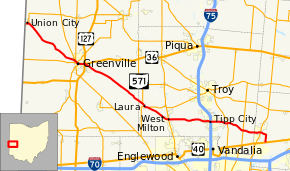
Ohio State Route 571
| |||||||
|---|---|---|---|---|---|---|---|
 | |||||||
| Route information | |||||||
| Maintained by ODOT | |||||||
| Length: | 50.51 mi[1] (81.29 km) | ||||||
| Existed: | 1962[2] – present | ||||||
| Major junctions | |||||||
| West end: |
| ||||||
|
| |||||||
| East end: |
| ||||||
| Location | |||||||
| Counties: | Darke, Miami, Clark | ||||||
| Highway system | |||||||
| |||||||

State Route 571 (SR 571) is an east–west state highway in west-central Ohio, part of a statewide road transportation system. It indirectly connects the cities of Union City and Greenville with Springfield via a final 10.7 miles (17.2 km) on U.S. Route 40. State Route 571 has many curves throughout its length, including dangerously sharp ones where many accidents have occurred, especially near the unincorporated village of Coletown in Darke County and east of Tipp City at State Routes 201 and 202.
Route description
State Route 571 starts in the Indiana/Ohio border town of Union City. To the west, it turns into Indiana State Route 28, which goes west toward Albany and Alexandria, Indiana. To the east, 571 goes southeast through Hill Grove and Coletown, and then parallels Greenville Creek into Greenville. From Greenville it continues southeast through Painter Creek and Laura to West Milton where it turns due east, passes over Interstate 75 to Tipp City and New Carlisle. About 3 miles (4.8 km) southeast of New Carlisle, Route 571 meets U.S. Route 40, the eastern terminus of the state route.
Although no longer a state route, the road keeps on going across US 40 as County Highway 303 "Medway-Carlisle Road" in Clark County. The road continues south, through the village of Medway and further on it turns into the northern terminus of I-675 at I-70.
History
The Union City-to-Springfield roads have been part of the Ohio state highway system since 1912.[3] Before 1923, numerous highway numbers comprised the current route of SR 571.[4] In 1923, the route between Greenville and then-SR 1 (now US 40); the remainder of the route between Union City and Greenville was the westernmost segment of SR 29.[5] By 1932, SR 29 was truncated to Urbana with US 36 taking over its former route between Greenville and Urbana; SR 71 was also extended from Greenville to the Indiana state line in Union City.[6][7] By 1939, the entire length of SR 71 had been paved.[8][9]
Following the extension to Union City, no major changes to the routing of SR 71 and SR 571 have been made. The only change to the highway came in 1962 when Ohio renumbered state highways that shared route numbers with proposed Interstates. Because of I-71, SR 71 was renumbered to SR 571.[10][11]
An unrelated SR 571 was in existence from 1937 to 1957 in Bridgewater Township, Williams County.[12][13][14][15] This SR 571 ran from US 20 to the Michigan state line. In 1957, SR 576 was extended north and took over the 4-mile-long (6.4 km) highway.
Major intersections
| County | Location | mi[1] | km | Destinations | Notes |
|---|---|---|---|---|---|
| Darke | Union City | 0.00 | 0.00 | Indiana state line | |
| Greenville | 11.23 | 18.07 | Western end of SR 49 concurrency | ||
| 11.62 | 18.70 | Western terminus of SR 118 | |||
| 11.91 | 19.17 | Eastern end of SR 118 concurrency; western end of SR 121 concurrency; eastern terminus of SR 502 | |||
| 12.18 | 19.60 | Eastern end of SR 49 / SR 121 concurrency | |||
| 13.32– 13.51 | 21.44– 21.74 | Interchange | |||
| Miami | Union Township | 25.96 | 41.78 | Western end of SR 721 concurrency | |
| Laura | 26.31 | 42.34 | Eastern end of SR 721 concurrency | ||
| Union Township | 27.17 | 43.73 | Western terminus of SR 55 | ||
| West Milton | 31.25 | 50.29 | Western end of SR 48 concurrency | ||
| 31.29 | 50.36 | Eastern end of SR 48 concurrency | |||
| Tipp City | 38.82 | 62.47 | Exit 68 (I-75) | ||
| Bethel Township | 41.85 | 67.35 | |||
| 44.96 | 72.36 | ||||
| Clark | New Carlisle | 48.13 | 77.46 | ||
| Bethel Township | 50.52 | 81.30 | |||
1.000 mi = 1.609 km; 1.000 km = 0.621 mi
| |||||
References
- 1 2 Ohio Department of Transportation. "Technical Services Straight Line Diagrams". Retrieved April 30, 2010.
- ↑ "Will Rt. 75 Become Known As Rt. 93?". The Logan Daily News. April 27, 1962. p. 1. Retrieved June 10, 2016 – via Newspapers.com.

- ↑ Map of Ohio Showing Inter-County Highways (MrSID) (Map). Cartography by James R. Marker, State Highway Commissioner. Ohio State Highway Department. 1912. Retrieved August 18, 2013.
- ↑ Map of Ohio State Highways Showing All Improved Roadways (MrSID) (Map). Cartography by E.C. Blosser. Ohio Department of Highways and Public Works. 1922. Retrieved August 18, 2013.
- ↑ Map of Ohio Showing State Routes (MrSID) (Map). Cartography by L.A. Boulay, Director. ODOH. 1923. Retrieved August 18, 2013.
- ↑ Map of Ohio Showing State Highway System (MrSID) (Map). Cartography by O.W. Merrell, Director. ODOH. 1931. Retrieved August 19, 2013.
- ↑ Map of Ohio Showing State Highway System (MrSID) (Map). Cartography by O.W. Merrell, Director. ODOH. 1932. Retrieved August 19, 2013.
- ↑ Official 1938 Ohio Highway Map (MrSID) (Map). Cartography by John Jaster, Jr., Director. ODOH. 1938. Retrieved August 19, 2013.
- ↑ Ohio Highway Map 1939 (MrSID) (Map). Cartography by Robt. S. Beightler, Director. ODOH. 1939. Retrieved August 19, 2013.
- ↑ 1962 Official Ohio Highway Map (MrSID) (Map). Cartography by P.E. Masheter, Director. ODOH. 1962. Retrieved September 2, 2013.
- ↑ Ohio Official Highway Map (MrSID) (Map). Cartography by ODOH. ODOH. 1964. Retrieved September 2, 2013.
- ↑ 1936 Official Highway Map (MrSID) (Map). Cartography by John Jaster, Jr., Director. ODOH. 1936. Retrieved August 19, 2013.
- ↑ Official Ohio Highway Map 1937 (MrSID) (Map). Cartography by John Jaster, Jr., Director. ODOH. 1937. Retrieved August 19, 2013.
- ↑ Ohio Highway Map 1955 (MrSID) (Map). Cartography by S.O. Linzell, Director. ODOH. 1955. Retrieved September 23, 2013.
- ↑ Ohio Highway Map 1957 (MrSID) (Map). Cartography by George J. Thormyer, Acting Director. ODOH. 1957. Retrieved September 23, 2013.
External links
 Media related to Ohio State Route 571 at Wikimedia Commons