Ohio State Route 265
| ||||
|---|---|---|---|---|
 | ||||
| Route information | ||||
| Maintained by ODOT | ||||
| Length: | 18.33 mi[1][2][3] (29.50 km) | |||
| Existed: | 1927[4][5] – present | |||
| Major junctions | ||||
| West end: |
| |||
| East end: |
| |||
| Location | ||||
| Counties: | Guernsey, Noble, Belmont | |||
| Highway system | ||||
| ||||

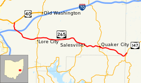
State Route 265 (SR 265) is an 18.33-mile-long (29.50 km) east–west state highway in the eastern portion of the U.S. state of Ohio. The western terminus of SR 265 is at its junction with US 40 approximately 2.50 miles (4.02 km) east of the city limits of Cambridge. The highway's eastern terminus is at a T-intersection with SR 147 nearly 3 miles (4.8 km) southwest of Barnesville.
Route description
The path of SR 265 takes it through the eastern half of Guernsey County, the northeasternmost portion of Noble County and just into the southwestern corner of Belmont County. No part of this highway is included within the National Highway System (NHS). The NHS is a system of routes determined to be most important for the economy, mobility and defense of the nation.[6]
History
SR 265 was established in 1927. The designation was applied to a stretch of roadway that was formerly a portion of SR 148. It has maintained the same routing through portions of Guernsey, Noble and Belmont Counties throughout its history.[4][5]
Major intersections
| County | Location | mi[1][2][3] | km | Destinations | Notes | |||
|---|---|---|---|---|---|---|---|---|
| Guernsey | Center Township | 0.00 | 0.00 | |||||
| 4.58 | 7.37 | |||||||
| Salesville | 11.54 | 18.57 | Northern terminus of SR 761 | |||||
| Quaker City | 13.77 | 22.16 | ||||||
| Noble |
No major junctions | |||||||
| Guernsey |
No major junctions | |||||||
| Belmont | Warren Township | 18.33 | 29.50 | |||||
| 1.000 mi = 1.609 km; 1.000 km = 0.621 mi | ||||||||
References
- 1 2 Ohio Department of Transportation. "Technical Services Straight Line Diagrams: SR 265, Guernsey County" (PDF). Retrieved 2011-04-29.
- 1 2 Ohio Department of Transportation. "Technical Services Straight Line Diagrams: SR 265, Noble County" (PDF). Retrieved 2011-04-29.
- 1 2 Ohio Department of Transportation. "Technical Services Straight Line Diagrams: SR 265, Belmont County" (PDF). Retrieved 2011-04-29.
- 1 2 Map of Ohio Showing State Routes (MrSID) (Map). Cartography by ODHPW. Ohio Department of Highways and Public Works. August 1926. Retrieved 2011-04-29.
- 1 2 Map of Ohio Showing State Highway System (MrSID) (Map). Cartography by ODHPW. Ohio Department of Highways and Public Works. June 1927. Retrieved 2011-04-29.
- ↑ National Highway System: Ohio (PDF) (Map). Federal Highway Administration. December 2003. Retrieved 2011-04-29.