Ohio State Route 45
| ||||
|---|---|---|---|---|
|
Route of SR 45 highlighted in red | ||||
| Route information | ||||
| Maintained by ODOT | ||||
| Length: | 96.62 mi[1] (155.49 km) | |||
| Existed: | 1924 – present | |||
| Major junctions | ||||
| South end: |
| |||
| North end: |
| |||
| Location | ||||
| Counties: | Columbiana, Mahoning, Trumbull, Ashtabula | |||
| Highway system | ||||
| ||||

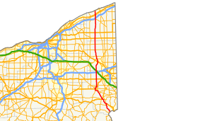
State Route 45 (SR 45) is a north–south state highway in the northeastern portion of the U.S. state of Ohio. Its southern terminus is at the State Route 7/State Route 39 concurrency in Wellsville, and its northern terminus is at State Route 531 about 3 miles (4.8 km) west of Ashtabula.
History
- 1924 – Original route established;[2] originally routed from Lisbon to Geneva along its current route from Lisbon to 1½ miles south of Salem, from 1½ miles south of Salem to 1½ miles north of Salem on a currently unnumbered road, along its current route from 1½ miles north of Salem to North Bloomfield, from North Bloomfield to Windsor on a currently unnumbered road, and from Windsor to Geneva along current State Route 534.[3]
- 1931 – By this time, rerouted from North Bloomfield to Orwell along a previously unnumbered road, and from Orwell to Windsor along U.S. Route 322; original routing from North Bloomfield to Windsor decertified.[3]
- 1932 – Extended to Wellsville along the former alignment of State Route 153 from Wellsville to West Point, and along U.S. Route 30 (formerly State Route 5 before 1926) from West Point to Lisbon.[3]
- 1938 – Rerouted north from Orwell to its current northern terminus; former alignment from Windsor to Geneva certified as State Route 534.[3]
- 1976 – Routed around Salem on newly completed bypass (southwest portion completed in 1972; bypass certified as State Route 45B in 1974).[3]
- 1997 – From Lisbon to State Route 558 upgraded to divided highway.[3]
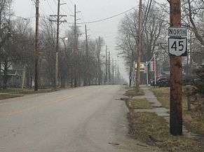
Route 45 in Rock Creek, Ashtabula
Major intersections
| County | Location | mi | km | Destinations | Notes |
|---|---|---|---|---|---|
| Columbiana | Wellsville | 0.00 | 0.00 | SR 45 begins at westbound exit ramp from SR 7 / SR 39 concurrency | |
| Madison Township | 8.95 | 14.40 | SR 45 joins US 30 westbound; US 30 joins SR 11 to the east 0.10 mi. | ||
| 9.78 | 15.74 | SR 518 ends to the south (northern terminus). | |||
| Lisbon | 14.80 | 23.82 | Eastern terminus of US 30/SR 45/SR 154 concurrency; SR 154 continues east (Lincoln Way). | ||
| 15.34 | 24.69 | US 30 continues west (Lincoln Way); SR 154 begins concurrent to the east (western terminus); SR 164 joins from the south; SR 517 begins concurrent to the north (Market Street) (western terminus). | |||
| 15.69 | 25.25 | SR 164/SR 517 leave concurrent to the northeast (Lee Street). | |||
| Salem Township | 20.73 | 33.36 | SR 558 begins to the northeast (western terminus). | ||
| Salem | 24.50 | 39.43 | South Lincoln Avenue | Former routing of SR 45 | |
| Perry Township | 25.68 | 41.33 | New Garden Road | ||
| 26.91 | 43.31 | US 62 joins from the west (Salem-Alliance Road) | |||
| 27.32 | 43.97 | Benton Road | |||
| 29.09 | 46.82 | Interchange; eastern terminus of SR 14 Temporary | |||
| 29.34 | 47.22 | US 62 leaves to the east. | |||
| Mahoning | Goshen–Green township line | 30.60 | 49.25 | South Range Road | |
| Ellsworth Township | 36.15 | 58.18 | Akron-Canfield Road | ||
| Jackson Township | 40.78 | 65.63 | Formerly part of SR 18 (Mahoning Avenue) | ||
| Trumbull | Lordstown | 44.56 | 71.71 | ||
| Warren | 51.08 | 82.21 | SR 169 begins east (western terminus) concurrent with US 422 (Market Street NW) | ||
| Champion Township | 54.36 | 87.48 | Interchange | ||
| 56.67 | 91.20 | Center Street | |||
| Bristol Township | 62.30 | 100.26 | Greenville Road | ||
| Bloomfield Township | 67.45 | 108.55 | Kinsman Road NW | ||
| Ashtabula | Orwell | 72.53 | 116.73 | ||
| Rome Township | 77.38 | 124.53 | |||
| Austinburg Township | 89.05 | 143.31 | |||
| 90.07 | 144.95 | I-90 exit 223 | |||
| Saybrook Township | 92.45 | 148.78 | S. Ridge Road West | ||
| 93.48 | 150.44 | N. Ridge Road West | |||
| 96.62 | 155.49 | Lake Road West | |||
1.000 mi = 1.609 km; 1.000 km = 0.621 mi
| |||||
References
- ↑ Ohio Department of Transportation. "Technical Services Straight Line Diagrams".
- ↑ Explanation of the Ohio State Highway System (The Unofficial Ohio State Highways Web Site) by John Simpson Archived May 23, 2006, at the Wayback Machine.
- 1 2 3 4 5 6 Route 45 (The Unofficial Ohio State Highways Web Site) by John Simpson Archived December 21, 2004, at the Wayback Machine.
This article is issued from Wikipedia - version of the 11/15/2016. The text is available under the Creative Commons Attribution/Share Alike but additional terms may apply for the media files.