Ohio State Route 5
| |||||||
|---|---|---|---|---|---|---|---|
 | |||||||
| Route information | |||||||
| Maintained by ODOT | |||||||
| Length: | 50.91 mi[1] (81.93 km) | ||||||
| Existed: | 1932 – present | ||||||
| Major junctions | |||||||
| West end: |
| ||||||
|
| |||||||
| East end: |
| ||||||
| Location | |||||||
| Counties: | Portage, Trumbull | ||||||
| Highway system | |||||||
| |||||||

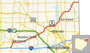
State Route 5 (SR 5) is an east–west state highway in the northeastern portion of the U.S. state of Ohio. Its western terminus is at Interstate 76 at its interchange with State Route 44 about 3.5 miles (5.6 km) south of Ravenna, and its eastern terminus is at the Pennsylvania state line northeast of Kinsman; this point is also the western terminus of Pennsylvania Route 58 which begins to the east.
History
- 1932 – Current route established; originally routed along the former State Route 36 from Wooster to the Pennsylvania state line along current State Route 585, State Route 59, its current routing east of Ravenna, and a currently unnumbered road through Akron.[2]
- unknown – Realigned from 4 miles (6.4 km) northeast of Warren to Cortland.[2]
- 1969 – Western terminus moved to 3½ south of Ravenna, and routed along new bypass route to 3 miles (4.8 km) east of Ravenna; former alignment from Wooster to State Route 21 certified as State Route 585; former alignment from 3 miles (4.8 km) south of Cuyahoga Falls to 3 miles (4.8 km) east of Ravenna certified as State Route 59.[2]
- unknown – Realigned from 3 miles (4.8 km) east of Ravenna to 7 miles (11 km) west of Warren.[2]
- 1970 – Warren Bypass completed from U.S. Route 422 to 3 miles (4.8 km) northeast of Warren (Elm Road) and certified as State Route 5B.[2]
- 1971 – Warren Bypass extended to 3 miles (4.8 km) west of Warren; entire bypass certified as State Route 5 (State Route 5B designation removed).[2]
- 1978 – Warren Bypass upgraded to freeway.[2]
Before 1932
- 1924 – Original route established;[3] originally routed from the Indiana state line 14 miles (23 km) west of Van Wert to the Pennsylvania state line 6 miles (9.7 km) east of East Liverpool along the current U.S. Route 30 from Indiana to Mansfield, current U.S. Route 42 from Mansfield to Ashland, current U.S. Route 250 from Ashland to 5 miles (8.0 km) west of Wooster, U.S. Route 30 from 5 miles (8.0 km) west of Wooster to 2 miles (3.2 km) east of Dalton, State Route 172 from 2 miles (3.2 km) east of Dalton to Waco, U.S. Route 30 from Waco to East Liverpool, and State Route 39 from East Liverpool to Pennsylvania.[2]
- 1926 – Truncated at Delphos and 5 miles (8.0 km) west of Wooster; Indiana to Delphos and 5 miles (8.0 km) west of Wooster to East Liverpool certified as U.S. Route 30; East Liverpool to Pennsylvania certified as State Route 39; Mansfield to Ashland dually certified as U.S. Route 42 and State Route 5; Ashland to 5 miles (8.0 km) west of Wooster dually certified as State Routes 5 and 6.[2]
- 1929 – State Route 5 dual certification removed from U.S. Route 42 and State Route 6.[4]
- 1932 – Delphos to Mansfield certified as U.S. Route 30N.[2]
Major intersections
| County | Location | mi | km | Destinations | Notes |
|---|---|---|---|---|---|
| Portage | Rootstown Township | 0.00 | 0.00 | SR 5 begins at I-76 exit ramp; SR 44 joins from the south (I-76 exit 38) | |
| 0.77 | 1.24 | South Prospect Street | Former routing of SR 44 (SR 44C begins north with a length of 0.19 mi.); SR 5/SR 44 bypass route begins | ||
| Ravenna Township | 3.70 | 5.95 | SR 14 passes over northwest-southeast; SR 44 leaves concurrency via full-access interchange to join SR 14 bypass northwest | ||
| 4.32 | 6.95 | SR 59 ends to the west; end of SR 5 bypass | |||
| Paris Township | 10.29 | 16.56 | Newton Falls Road | Former routing of SR 5 | |
| 12.69 | 20.42 | SR 225 ends to the south | |||
| Trumbull | Braceville Township | 17.00 | 27.36 | SR 534 crosses south–north | |
| 18.49 | 29.76 | Turnpike passes over northwest-southeast; full-access interchange (turnpike exit 209) | |||
| 20.22 | 32.54 | Warren Ravenna Road | Former routing of SR 5 | ||
| 20.79 | 33.46 | SR 82 joins from the west | |||
| Warren Township | 21.12 | 33.99 | Burnett Street | Former routing of SR 5 | |
| Western end of freeway (Warren Bypass) | |||||
| 22.27 | 35.84 | West Market Street – Leavittsburg, Warren | Former SR 82 alignment (after bypass was constructed) begins to the east; full-access interchange | ||
| 24.00 | 38.62 | US 422 passes under northwest-southeast; full-access interchange | |||
| Champion Heights | 26.16 | 42.10 | SR 45 passes under south–north; full-access interchange | ||
| Bazetta Township | 28.25 | 45.46 | Perkins Jones Road | Road passes over; full-access interchange | |
| 29.50 | 47.48 | SR 5 exits freeway, continuing northeast; SR 82 continues southeast on freeway | |||
| 30.73 | 49.46 | Warren Meadville Road | Former routing of SR 5 | ||
| 32.80 | 52.79 | SR 305 crosses west–east | |||
| Cortland | 33.66 | 54.17 | SR 46 joins from the south | ||
| 33.80 | 54.40 | SR 46 leaves to the north; former southwestern alignment of SR 5 | |||
| Johnston Township | 37.70 | 60.67 | SR 11 passes under south–north; full-access interchange | ||
| 39.75 | 63.97 | SR 88 joins from the west | |||
| 40.00 | 64.37 | SR 193 crosses south–north | |||
| 41.41 | 66.64 | SR 88 leaves to the east | |||
| Kinsman Township | 46.35 | 74.59 | SR 7 joins from the south | ||
| 47.54 | 76.51 | SR 87 ends to the west | |||
| 47.89 | 77.07 | SR 7 leaves to the north | |||
| 50.91 | 81.93 | Continuation into Pennsylvania | |||
1.000 mi = 1.609 km; 1.000 km = 0.621 mi
| |||||
References
- ↑ Ohio Department of Transportation. "Technical Services Straight Line Diagrams".
- 1 2 3 4 5 6 7 8 9 10 Route 5 (The Unofficial Ohio State Highways Web Site) by John Simpson
- ↑ Explanation of the Ohio State Highway System Archived May 23, 2006, at the Wayback Machine. (The Unofficial Ohio State Highways Web Site) by John Simpson
- ↑ Ohio Department of Transportation Official maps for 1928 and 1929
External links
This article is issued from Wikipedia - version of the 11/19/2016. The text is available under the Creative Commons Attribution/Share Alike but additional terms may apply for the media files.