U.S. Route 30 in Ohio
| ||||
|---|---|---|---|---|
| Lincoln Highway | ||||
|
US 30 highlighted in red | ||||
| Route information | ||||
| Maintained by ODOT | ||||
| Length: | 245.69 mi[1] (395.40 km) | |||
| Major junctions | ||||
| West end: |
| |||
|
| ||||
| East end: |
| |||
| Location | ||||
| Counties: | Paulding, Van Wert, Putnam, Allen, Hancock, Wyandot, Crawford, Richland, Ashland, Wayne, Stark, Columbiana | |||
| Highway system | ||||
| ||||


U.S. Route 30 (US 30) is a United States Numbered Highway that runs from Astoria, Oregon, to Atlantic City, New Jersey. In the US state of Ohio, it is a major, 245-mile-long (394 km), east–west highway that runs through the northern section of Ohio. Overall, the highway runs through rural areas of the state dominated by farm fields or woodlands; some segments are urban in character in the Mansfield and Canton areas.
The first transportation routes along US 30 in the state was the Lincoln Highway. In the early 1920s, two different state routes in the initial state route system. When the United States Numbered Highway System was first designated on November 11, 1926, the new US 30 replaced the other designations along its route. Since creation, the road has been moved and realigned several times. Starting in the early 1950s, various sections were upgraded to freeways, bypassing several cities and villages in the area. Future improvements to the route of US 30 includes a proposed easterly extension of the four-lane divided highway from Canton to SR 11, near Lisbon.
Route description
US 30 runs for 249.69 miles (401.84 km) through northern Ohio.[1] Between Indiana state line and Canton, US 30 is a divided highway. With sections of freeway between Van Wert and Delphos, Upper Sandusky and Mansfield, around Wooster and a final section in the area of Massillon and Canton.[2] Like other state routes, it is maintained by the Ohio Department of Transportation (ODOT). All of US 30 in the state has been listed on the National Highway System.[3]
Indiana to Upper Sandusky
US 30 enters Ohio heading southeast, as a four-lane divided highway passing through rural farmland. The highway passes through southwestern Paulding County, before entering Van Wert County. The route has a short concurrency with State Route 49 (SR 49). US 30 has a trumpet interchange with US 224; this interchange is the western end of the US 224 concurrency. The road curves toward the east, passing near commercial properties, on the north side of Van Wert. The concurrency ends at a folded diamond interchange, with US 127. US 224 heads north concurrent with US 127. US 30 passes through farmland and curves southeasterly, becoming a limited access road. While heading southeasterly the road has an interchange with Lincoln Highway. The highway turns towards the east, crossing over the Little Auglaize River. After the river, the road has a diamond interchange with SR 66, providing access to Delphos.[2][4]
US 30 curves southeasterly entering into Putnam County and crossing over SR 190, but there is no direct access between the two routes. After passing over SR 190, US 30 has an interchange with the Lincoln Highway, which also provides access to Delphos. The highway has an incomplete interchange with SR 309. After SR 309, US 30 becomes four-lane highway with cross-street traffic. The road crosses over the Auglaize River, followed by the Ottawa River. After the two rivers the highway has an interchange with SR 115, followed by an interchange with SR 65. US 30 crosses over Norfolk Southern railroad track and Interstate 75 (I–75), with no access to I–75 at this location. US 30 and I–75 parallel each other for a short distance, before I–75 curves towards the north. After I–75 curves north, US 30 has an interchange with SR 696; this interchange provides access to both I–75 and the village of Beaverdam. The road continues east and enters Hancock County, having an interchange with SR 235.[2][4][5]
US 30 has a folded diamond interchange with US 68, immediately south of Williamstown. After US 68, US 30 crosses over a CSX railroad track and crosses over the Blanchard River. The highway has an interchange with SR 37, before crossing into Wyandot County. In Wyandot County US 30 passes under SR 293; there is no direct connection between the two routes. The road curves towards the northeast, having an interchange with the Lincoln Highway. US 30 has an interchange with US 23, this interchange is the western end of the concurrency with US 23. US 23 and US 30 head due east crossing over CSX railroad track and having an interchange with SR 199. The concurrency has an interchange with SR 53/SR 67, before the road curves towards the southeast. The highway crosses over the Sandusky River and has an interchange with the Lincoln Highway, before curving towards the south. The concurrency with US 23 ends at an interchange east of Upper Sandusky.[2][4][5]
Upper Sandusky to Canton
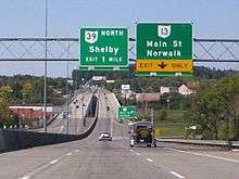
US 30 heads due east as a four-lane divided highway with cross-road traffic, passing through farmland. The road has an interchange with SR 231, before crossing into Crawford County. After entering into Crawford County, US 30 becomes a four-lane limited access freeway, continues passing through farmland. The highway crosses over Chicago, Fort Wayne and Eastern Railroad track, followed by an interchange with SR 4/SR 19/SR 100. The route crosses over a Norfolk Southern railroad track and has an interchange with SR 98. After the interchange with SR 98, US 30 crosses over a Chicago, Fort Wayne and Eastern railroad track and the Sandusky River again. The road has an interchange at SR 602, followed by an interchange with SR 598. The road crosses over a CSX railroad tracks, followed by an interchange with SR 61. US 30 passes under SR 181 and SR 314, with no access to either route. After passing under SR 314 the route enters the city of Mansfield. The route has an incomplete interchange with SR 309, followed by an interchange at SR 39. After SR 39, US 30 crosses over a Norfolk Southern railroad track and has an interchange with SR 13, followed by an interchange with SR 545.[2][4][6]
US 30 has an interchange with US 42 and I–71. The road leaves Mansfield and becomes a four-lane highway with cross-street traffic. The highway has an intersection with SR 603 and an intersection with SR 511. The route has an interchange with SR 60. The road has an intersection with SR 89. US 30 has an interchange with US 250, and the two routes continue concurrent towards the east. The highway enters Wooster and has an interchange with SR 3. After the interchange at SR 3, the route passes over Norfolk Southern railroad tracks, before having an interchange with SR 302. The road parallels a river, before having an interchange with the eastern end of the US 250 concurrency and the eastern end of the SR 3 concurrency. US 30 leaves Wooster and passes through farmland. The highway has a traffic signal at a T-intersection with SR 57. The route enters Dalton and has a T-intersection with the western terminus of US 30 Alternate.[2][4][5]
US 30 by-passes most of Dalton to the south, having a traffic signal at SR 94. The highway has a T-intersection with the eastern terminus of US 30 Alternate. US 30 has an interchange with SR 172, and US 30 becomes a four-lane highway with limited access. The highway passes over SR 93, with no access between the two routes. US 30 has an interchange with SR 241, this interchange provides access to SR 93. East of the interchange at SR 241, US 30 crosses over the Tuscarawas River and has an interchange at US 62/SR 21, US 62 continues east concurrent with US 30. The route has an interchange with SR 627, the western terminus of SR 627, followed by an interchange with SR 297, the southern terminus of SR 297. After US 30/US 62 passes over SR 297, with interchange access, the route enters the city of Canton. US 30 has an interchange with I–77, this interchange is also the eastern end of the US 62 concurrency. East of I–77, US 30 has a short concurrency with SR 43. The four-lane divided highway with limited access ends at an interchange with Trump Avenue. US 30 heads north on Trump Avenue, as a four-lane highway with a center turn lane. US 30 has a traffic signal at SR 172, at this traffic signal US 30 turns east onto SR 172.[2][4]
Canton to West Virginia
US 30 and SR 172 head east as a two-lane highway, passing through mostly residential properties. US 30 enters East Canton, where US 30 turns south onto Cedar Street, while SR 172 continues east. The route turns onto Walnut Street and one block later has a traffic signal at SR 44; this is the west end of the concurrency with SR 44. The two routes head southeast passing through woodland and paralleling a Wheeling and Lake Erie railroad track. SR 44 turns south and US 30 continues southeasterly, passing through woodland and farmland, with houses. The road passes through Robertsville and curves towards the northeast, before curving back towards the southeast. The highway enters Minerva and passes through residential and commercial properties. In Minerva, the route curves northeasterly and has an at-grade crossing with a Ohi-Rail railroad track. The highway curves towards the east and has an at-grade crossing with a Norfolk Southern railroad crossing. After the second railroad crossing the highway passes through East Rochester. After East Rochester US 30 passes through farmland and woodland, paralleling a Norfolk Southern railroad track.[2][4][5][5]
US 30 has a four-way stop at an intersection with SR 9 and SR 644, in Kensington. SR 9 and US 30 head northeast concurrent heading towards Hanoverton. In Hanoverton SR 9 turns due north and US 30 continues northeasterly, before turning easterly. US 30 enters Lisbon over Little Beaver Creek and is signed as Lincoln Way passing through residential properties. As the highway enters downtown the properties become more commercial in type. In downtown, US 30 has a traffic signal at SR 45/SR 164/SR 154. This intersection is the southern terminus for SR 517 and the western terminus for SE 154. SR 45/SR 154 continues east concurrent with US 30. The concurrency passes through a few more blocks of commercial properties, before entering residential properties. The concurrency with SR 154 ends, when US 30 and SR 45 turn southeasterly and SR 154 continues east towards Elkton and SR 11. The highway leaves Lisbon and passes through woodland as a two-lane highway. At West Point, US 30 turns easterly and SR 45 continues towards the south, just before an interchange with SR 11.[2][4]
US 30 enters SR 11 and the concurrency heads towards the southeast, as a four-lane divided highway with limited access, passing through woodland. The route has an interchange at SR 7, this is the northern end of the SR 7 concurrency. The highway enters East Liverpool and has an interchange with SR 7 and SR 39. This interchange is the southern terminus of the SR 7 concurrency and the western end of the SR 39 concurrency. The road curves towards the east and parallels the Ohio river and Norfolk Southern railroad tracks. The highway curves towards the northeast and has an interchange with SR 39, the eastern end of the concurrency with SR 39. US 30 and SR 11 curve towards the southeast and cross over the railroad tracks, before crossing the Ohio River on the Jennings Randolph Bridge, and into West Virginia, with SR 11 ending at the state line.[2][4][5]
History
The Lincoln Highway was the first route to follow the corridor of US 30 in Ohio. The Lincoln Highway was established in 1913, following the current route of SR 309 and SR 81.[7][8] Improvements and realignment to the highway were planned in 1917 and was to start in the spring of 1918. The route was built to relieve some of the railroad congestion.[9] The Lincoln Highway realignment project was completed in 1939 and moved the Lincoln Highway to the modern US 30 corridor.[8] The Lincoln Highway in Ohio became known as SR 5 between Indiana state line and Mansfield, SR 10 between Mansfield and Wooster, and SR 5 between Wooster and Pennsylvania.[10][11][11] In 1925, the Federal Highway Association was established and one year later US 30 was established.[7] US 30 followed the current route of SR 309.[12][13] US 30 eastern terminus in Ohio was relocated to the West Virginia state line, in 1928.[7] The route became divided in 1932, with US 30N taking the current alignment of US 30 and US 30S taking the current alignment of SR 309.[14][15]
The bypass around the south side of Dalton was completed in December 1953. In 1966 and 1967 a four-lane section of US 30 opened between SR 49 and US 224. US 30 became a four-lane highway between Indiana state line and SR 49 in 1969. Between 1970 and 1971, US 30 between Delphos and Beaverdam was completed. In 1971 the section of road between current SR 172, West of East Greenville, and SR 21 was open to traffic.[16] The divided routes were removed in 1974 with US 30S, becoming SR 309 and US 30N becoming US 30.[17][18] In 1979 the section of four-lane road between Van Wert and Delphos open to traffic. Also in 1979 US 30 between Dalton and the I–77 interchange was upgraded to a four-lane divided highway and opened to traffic.[16][19][20] Between 1983 and 1985 the section from I–77 to Trump Avenue was opened to traffic. In 1999 a four-lane section of US 30 was opened between SR 696 and SR 235. The highways between Upper Sandusky and Ontario was upgraded to a four-lane limited access highway and open in 2004 and 2005. During 2007 and 2008, the upgraded section of US 30 between SR 235 and Upper Sandusky, was opened to traffic.[16]
Future
The section of US 30 between Canton and SR 11 has been studied many times for upgrades since at least 1989.[16] The route was studied several times between 1991 and 2001.[21][22][23][24] The route was studied again was in 2010.[25] In 2012, the ODOT was studying the section again, with plans to create a toll highway along the corridor.[26] Plans to toll the future highway were rejected in 2013.[27] The expansion was discussed further in 2014, with a consensus brewing that local funding must be involved for the project to go ahead.[28] In September 2016 the director of the Ohio Department of Transportation approved a regional transportation improvement project allowing the counties of Stark, Carroll, and Columbiana, the three counties along the corridor, to work collectively to secure funding for the extension.[29]
Major intersections
| County | Location | mi[1] | km | Destinations | Notes |
|---|---|---|---|---|---|
| Paulding | Benton Township | 0.00 | 0.00 | Indiana state line | |
| Van Wert | Tully Township | 5.07 | 8.16 | Western end of SR 49 concurrency | |
| 6.41 | 10.32 | Eastern end of SR 49 concurrency | |||
| Pleasant Township | 12.15 | 19.55 | Western end of US 224 concurrency | ||
| Van Wert | 14.14 | 22.76 | Eastern end of US 224 concurrency | ||
| Ridge Township | Eastern end of divided highway Western end of freeway | ||||
| 20.15 | 32.43 | ||||
| Washington Township | 22.26 | 35.82 | |||
| 26.77 | 43.08 | ||||
| Allen | Marion Township | 28.40 | 45.71 | ||
| 29.21– 29.46 | 47.01– 47.41 | Western terminus of SR 309; eastbound exit and westbound entrance | |||
| Eastern end of freeway Western end of divided highway | |||||
| Sugar Creek Township | 37.79 | 60.82 | |||
| Monroe Township | 40.00 | 64.37 | |||
| Richland Township | 47.01– 47.26 | 75.66– 76.06 | |||
| Hancock | Orange Township | 54.29 | 87.37 | ||
| Madison Township | 63.35 | 101.95 | |||
| Delaware Township | 70.30 | 113.14 | |||
| Wyandot | Salem Township | 80.22 | 129.10 | ||
| 82.24 | 132.35 | Northern end of US 23 concurrency | |||
| Upper Sandusky | 82.90 | 133.41 | |||
| 84.15 | 135.43 | ||||
| 86.83 | 139.74 | ||||
| Crane Township | 88.20 | 141.94 | Southern end of US 23 concurrency | ||
| Antrim Township | 94.13 | 151.49 | |||
| Crawford | Eastern end of divided highway Western end of freeway | ||||
| Holmes Township | 99.07 | 159.44 | County Road 330 | ||
| Bucyrus | 102.64 | 165.18 | |||
| Liberty Township | 103.75 | 166.97 | |||
| Whetstone Township | 105.05 | 169.06 | |||
| Whetstone–Jefferson township line | 110.45 | 177.75 | |||
| Jefferson Township | 113.78 | 183.11 | |||
| Crestline–Galion city line | 116.32 | 187.20 | |||
| Richland | Springfield Township | 121.27 | 195.17 | 4th Street to | |
| Ontario | 124.89 | 200.99 | Lexington–Springmill Road | ||
| Mansfield | 126.47 | 203.53 | Eastern terminus of SR 309; westbound exit and eastbound entrance | ||
| 127.16 | 204.64 | Trimble Road | |||
| 128.08 | 206.12 | ||||
| 129.17 | 207.88 | Connects using East Longview Avenue eastbound | |||
| 129.69 | 208.72 | ||||
| 130.17 | 209.49 | Fifth Avenue | |||
| Madison Township | 131.42 | 211.50 | |||
| Mifflin Township | 132.61 | 213.42 | Laver Road | Right-in/right-out | |
| 133.74 | 215.23 | Reed Road | |||
| Eastern end of freeway Western end of divided highway | |||||
| 134.52 | 216.49 | ||||
| 134.84 | 217.00 | Koogle Road | |||
| Ashland | Mifflin Township | 136.64 | 219.90 | ||
| Vermillion Township | 140.43 | 226.00 | |||
| 142.71 | 229.67 | ||||
| Mohican Township | 146.81 | 236.27 | |||
| Wayne | Plain Township | 156.57– 157.14 | 251.97– 252.89 | Westbound exit and eastbound entrance; western end of US 250 concurrency | |
| Eastern end of divided highway Western end of freeway | |||||
| Wooster | 159.31 | 256.38 | Western end of SR 3 concurrency | ||
| 160.24 | 257.88 | ||||
| Wooster Township | 161.13 | 259.31 | Eastern end of US 250 concurrency | ||
| 161.69 | 260.21 | US 30 leaves Wooster Bypass; eastern end of SR 3 concurrency | |||
| East Union Township | 165.36 | 266.12 | Apple Creek Road | ||
| 168.93 | 271.87 | Carr Road | |||
| Eastern end of freeway Western end of divided highway | |||||
| East Union–Sugar Creek township line | 170.00 | 273.59 | Southern terminus of SR 57 | ||
| Dalton | 173.88 | 279.83 | |||
| Sugar Creek Township | Eastern end of divided highway Western end of freeway | ||||
| 175.88– 175.96 | 283.05– 283.18 | Western terminus of SR 172; eastbound exit and westbound entrance | |||
| Stark | Tuscarawas Township | 177.25 | 285.26 | Alabama Avenue | Westbound exit and eastbound entrance |
| 180.34 | 290.23 | ||||
| Massillon | 184.02 | 296.15 | Western end of US 62 concurrency | ||
| Perry Township | 185.91 | 299.19 | Western terminus of SR 627 | ||
| Canton | 188.90– 189.38 | 304.01– 304.78 | Southern terminus of SR 297 | ||
| 190.55 | 306.66 | Harrison Avenue | |||
| 191.05– 191.54 | 307.47– 308.25 | Eastern end of US 62 concurrency | |||
| 191.91 | 308.85 | Western end of SR 43 concurrency | |||
| 193.28 | 311.05 | Eastern end of SR 43 concurrency | |||
| 194.56 | 313.11 | Trump Avenue | |||
| 194.81 | 313.52 | Eastern end of freeway | |||
| Canton Township | 195.49 | 314.61 | Western end of SR 172 concurrency | ||
| East Canton | 197.39 | 317.67 | Eastern end of SR 172 concurrency | ||
| 197.60 | 318.01 | Western end of SR 44 concurrency | |||
| Osnaburg Township | 202.79 | 326.36 | Eastern end of SR 44 concurrency | ||
| Minerva | 208.69 | 335.85 | Southern end of SR 44 concurrency | ||
| 209.72 | 337.51 | Northern end of SR 183 concurrency | |||
| Columbiana | Hanover Township | 217.11 | 349.40 | Southern end of SR 9 concurrency | |
| Hanoverton | 218.65 | 351.88 | Northern end of SR 9 concurrency | ||
| Center Township | 226.12 | 363.90 | Eastern terminus of SR 172 | ||
| Lisbon | 228.10 | 367.09 | Western end of SR 45 concurrency; western terminus of SR 154; southern terminus of SR 517 | ||
| 228.64 | 367.96 | Eastern end of SR 154 concurrency | |||
| Madison Township | 233.66 | 376.04 | |||
| 234.49 | 377.38 | Eastern end of SR 45 concurrency | |||
| 234.54 | 377.46 | Northern end of SR 11 concurrency | |||
| 238.28 | 383.47 | Northern end of SR 7 concurrency; northern terminus of SR 267 | |||
| St. Clair Township | 240.92 | 387.72 | Southern terminus of SR 170 | ||
| East Liverpool | 243.91 | 392.54 | Southern end of SR 7 concurrency; western end of SR 39 concurrency | ||
| 245.55 | 395.17 | Eastern end of SR 39 concurrency | |||
| Ohio River | 245.69 | 395.40 | Jennings Randolph Bridge | ||
| Continuation into West Virginia | |||||
1.000 mi = 1.609 km; 1.000 km = 0.621 mi
| |||||
Related routes
- U.S. Route 30N (former)
- U.S. Route 30S (former)
See also
List of unused highways in Ohio
References
- 1 2 3 Ohio Department of Transportation. "Technical Services Straight Line Diagrams". Retrieved February 4, 2013.
- 1 2 3 4 5 6 7 8 9 10 Ohio Highway Map (PDF) (Map). Cartography by ODOT. Ohio Department of Transportation. 2011. Retrieved July 26, 2013.
- ↑ National Highway System: Ohio (PDF) (Map). Federal Highway Administration. December 2003. Retrieved August 23, 2013.
- 1 2 3 4 5 6 7 8 9 Google (August 23, 2012). "Overview of U. S. Route 30 in Ohio" (Map). Google Maps. Google. Retrieved August 23, 2012.
- 1 2 3 4 5 6 Ohio Rail Transportation Map (PDF) (Map). Cartography by ODOT. Ohio Department of Transportation. 2011. Retrieved August 23, 2013.
- ↑ Ohio Rail Transportation Map (PDF) (Map). Cartography by ODOT. Ohio Department of Transportation. 2011. Retrieved August 23, 2013.
- 1 2 3 "Traveling the Lincoln Highway". Gettysburg Times. March 30, 2000. pp. A3. Retrieved August 23, 2013.
- 1 2 "Roider delivers Lincoln Highway speech". Ada Herald. May 23, 2007. Retrieved August 26, 1913. Check date values in:
|access-date=(help) - ↑ "Improve the Lincoln Highway". The Daily Times. Beaver, Pennsylvania. December 1, 1917. p. 6. Retrieved August 23, 2013.
- ↑ Ohio Department of Highways and Public Works (April 1922). Map of Ohio State Highways (MrSID) (Map). Columbus: Ohio Department of Highways and Public Works. Retrieved August 26, 2013.
- 1 2 Ohio Department of Highways and Public Works (July 1923). Map of Ohio Showing State Routes (MrSID) (Map). 1:760,320. Columbus: Ohio Department of Highways and Public Works. Retrieved August 26, 2013.
- ↑ Ohio Department of Highways and Public Works (August 1925). Map of Ohio Showing State Routes (MrSID) (Map). 1:760,320. Columbus: Ohio Department of Highways and Public Works. OCLC 5673562. Retrieved August 26, 2013.
- ↑ Ohio Department of Highways and Public Works (August 1, 1926). Map of Ohio Showing State Routes (MrSID) (Map). 1:760,320. Columbus: Ohio Department of Highways and Public Works. OCLC 5673562. Retrieved August 26, 2013.
- ↑ Ohio Department of Highways (1931). Map of Ohio Showing State Routes (MrSID) (Map). 1:760,320. Columbus: Ohio Department of Highways. OCLC 5673562, 7231737. Retrieved August 26, 2013.
- ↑ Ohio Department of Highways (1932). Map of Ohio Showing State Routes (MrSID) (Map). 1:760,320. Columbus: Ohio Department of Highways. OCLC 5673562, 7231704. Retrieved August 26, 2013.
- 1 2 3 4 "Timeline: U.S. Route 30 construction in Ohio". The Repository. March 2, 2010. Retrieved December 21, 2010.
- ↑ Ohio Department of Transportation (1973). Official Highway Map of Ohio (MrSID) (Map). 1:554,400. Columbus: Ohio Department of Transportation. OCLC 5673562. Retrieved August 26, 2013.
- ↑ Ohio Department of Transportation (1974). Official Highway Map of Ohio (MrSID) (Map). 1:554,400. Columbus: Ohio Department of Transportation. OCLC 5673562. Retrieved August 26, 2013.
- ↑ Ohio Department of Transportation (1978). Official Highway Map of Ohio (MrSID) (Map). 1:554,400. Columbus: Ohio Department of Transportation. OCLC 5673562, 13655727. Retrieved August 26, 2013.
- ↑ Ohio Department of Transportation (1979). Official Highway Map of Ohio (MrSID) (Map). 1:554,400. Columbus: Ohio Department of Transportation. OCLC 5673562, 7302607. Retrieved August 26, 2013.
- ↑ "Highway Winding gets push". The Vindicator. June 28, 1991. pp. B3. Retrieved August 24, 2013.
- ↑ "Route 30 Project". The Vindicator. August 4, 1993. pp. B1. Retrieved August 24, 2013.
- ↑ "Route 30 Relocation". The Vindicator. February 23, 1995. pp. B2. Retrieved August 24, 2013.
- ↑ "Route 30 Expansion". The Vindicator. December 10, 1996. pp. B3. Retrieved August 24, 2013.
- ↑ McElwain, Michael (May 17, 2010). "Group pushes for improved U.S. Route 30 corridor". The Review. East Liverpool, Ohio. Retrieved August 24, 2013.
- ↑ Armon, Rick (December 13, 2012). "Ohio Looks to Add Tolls to Complete U.S. 30 Improvements Through Drilling Country". Akron Beacon Journal. Retrieved December 14, 2012.
- ↑ Armon, Rick (January 27, 2014). "ODOT moving forward with U.S. Route 30 relocation in Stark County". Akron Beacon Journal. Retrieved November 20, 2014.
- ↑ "Route 30 Extension: Discussion of major construction project comes up again". The-Press-News. Archived from the original on 2015-12-08. Retrieved 2015-12-08.
- ↑ Byer, Kelly (October 6, 2016). "Stark, Carroll, Columbiana get blessing in combined Route 30 push". The Repository. Canton, Ohio. Retrieved October 7, 2016.
External links
| Previous state: Indiana |
Ohio | Next state: West Virginia |