Ohio to Erie Trail
| Ohio to Erie Trail | |
|---|---|
|
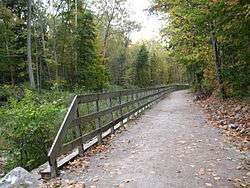
Ohio and Erie Canal Towpath Trail, located in the Cuyahoga Valley National Park | |
| Length | 318 mi (512 km)[1] |
| Location | Ohio, United States |
| Designation |
|
| Trailheads | Cincinnati to Cleveland (various) |
| Use | Multi-use |
| Hiking details | |
| Season | Year-round |
The Ohio to Erie Trail is a route for non-motorists that traverses the U.S. state of Ohio, from southwest to northeast. It is named for its endpoints, the Ohio River at Cincinnati and Lake Erie at Cleveland. The route largely consists of rail trails and other multi-use trails but also includes some on-road segments in anticipation of future segregated cycle facilities. The route as a whole is intended for bicyclists and hikers, while some trails along the route also permit equestrian and horse and buggy traffic.
History
The Ohio to Erie Trail began in 1991 as an outgrowth of the Ohio Bicycle Advisory Council.[2]
Path
The trail is divided into four separate sections:[3]
- Northern leg: Cleveland to Massillon
- Heart of Ohio leg: Massillon to Mount Vernon
- Central Ohio leg: Mount Vernon to London
- Southern leg: London to Cincinnati
The trail passes through regional parks, nature preserves, and other rural woodland. The trail is planned to be 453 miles (729 km) in length. Of that amount, 262 miles (422 km) are complete and in daily use, 54 miles (87 km) are under construction or in engineering design, and the final 137 miles (220 km) are awaiting final planning.
See also
References
- ↑ "Ohio to Erie Trail". Ohio Department of Transportation. Retrieved September 27, 2015.
- ↑ McNutt, Randy (14 March 2001). "Bike path to link Ohio's north, south Planners envision 462-mile trail". The Cincinnati Enquirer. Retrieved 3 September 2014.
- ↑ "Ohio to Erie Trail". Ohio Department of Transportation. Retrieved 18 September 2016.
External links
- The Ohio to Erie Trail official website
- Original Ohio to Erie Trail website
- Ohio to Erie Trail Paper Map
- Ohio to Erie Trail Digital Guide