Little Miami Scenic Trail
| Little Miami Scenic Trail | |
|---|---|
|
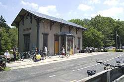
Yellow Springs Station in Greene County | |
| Length | 78.1 mi (125.7 km)[1][2] |
| Location | Southwestern Ohio |
| Designation |
North Country National Scenic Trail |
| Trailheads | Springfield to Newtown, Ohio |
| Use | Cycling, walking, rollerblading, horseback riding |
| Elevation | |
| Elevation change | −486 ft (−148 m)[3] |
| Highest point | Springfield trailhead |
| Lowest point | Little Miami Golf Center trailhead, Newtown |
| Hiking details | |
| Trail difficulty | Easy (fully accessible[4]) |
| Season | Year-round |
The Little Miami Scenic Trail is the third longest paved trail in the United States,[5] running 78.1 miles (125.7 km)[1] though five southwestern counties in the state of Ohio. The multi-use rail trail sees heavy recreational use by hikers and bicyclists, as well as the occasional horseback rider. Over 700,000 people made use of the trail in 2014.[6]
Most of the trail runs along the banks of the Little Miami River, in a dedicated, car-free corridor known as Little Miami State Park. This unusually linear state park passes though four counties, with a right-of-way running about 50 miles (80 km) long and averaging 66 feet (20 m) in width[7] for a total of about 707 acres (286 ha). Elsewhere, the corridor ranges from 8 to 10 feet (2.4 to 3.0 m) in width.[8]
The Little Miami Scenic Trail is signposted as State Bike Route 1 south of Xenia and State Bike Route 3 throughout.[9] It is the backbone of a nearly continuous network of paved multi-use trails, centered on the Miami Valley area, that stretches 330 miles (530 km) and connects the Cincinnati, Dayton, and Columbus metropolitan areas.[10] The Little Miami trail is an incrementally growing section of the Buckeye Trail and North Country National Scenic Trail, while the trail south of Xenia also forms the southern leg of the Ohio to Erie Trail.[11]
History
The largely wooded corridor was created along the right-of-way of the old Little Miami Railroad. The original railway bed is still visible beside the trail in various places along the trail route.
Together with the Ohio Department of Natural Resources, the local governments of Xenia and Yellow Springs purchased land along the abandoned railroad from 1973 and 1983.[12] In 1979, the land became an Ohio State Park.[7] The Loveland Bike Trail was added to the state park in 1984.[13] Two years later, the Ohio Department of Transportation received a grant from the Federal Highway Administration to complete the trail.[12]
By 1989, the trail stretched 13 miles (21 km), with its northern terminus at Morrow.[14] The original portion of the trail was dedicated on December 20, 1991.[15] The route ran mostly along the eastern bank of the Little Miami River, from Spring Valley in Greene County to the limits of Terrace Park in Hamilton County, across the river from Milford. The trail was extended northward to Xenia later that year[16] and to Springfield in 1998.[17] In 2006, after a protracted, 26-year battle with Terrace Park residents,[18] it was extended southward to Newtown.[19]
.svg.png)
In the late 2000s, state budget cuts caused portions of the trail to fall into disrepair, resulting in the temporary closure of some wooden bridges and rest areas.[20][21] However, an organization called the Friends of the Little Miami State Park Group [22] was founded late 2008 to focus attention and finances on critical portions to keep the trail open and make it safer. Most of the bridges within state park boundaries were paved or re-planked in 2009. In 2010, a failed parks levy prompted the Clark County Park District to indefinitely close its 5.6-mile (9.0 km) stretch of the trail, posting "No Trespassing" signs at park entrances.[23] Because this stretch of trail was partially built with federal funds, the Ohio Department of Natural Resources attempted to force its reopening.[24][25] The district reopened its parks in April 2011 with volunteer support.[26]
Originally designated State Bike Route 1,[27][28][29][30] the Little Miami Scenic Trail was renumbered in 2011 as State Bike Route 1 south of Xenia and State Bike Route 3 throughout. The concurrency from Newtown to Xenia is marked with "⅓" signs.[9]
Current route

Xenia made a deal to be the official start of the trail for a donation of land, making the mile markers change from the previous start. For the first 9 miles (14 km) to Xenia, the Little Miami Scenic Trail is operated by the Clark County Park District and the National Trail Parks and Recreation District.[17] From the Simon Kenton Trailhead in Springfield, the Little Miami trail runs southward parallel to U.S. Route 68 and continues to Yellow Springs. Near John Bryan State Park, the North Country Trail and Buckeye Trail enter from Dayton to the west.[11][31] For the next 15 miles (24 km) to Spring Valley, the Little Miami trail is managed by Greene County. At Xenia Station, it meets the Creekside Trail, as well as the Prairie Grass Trail, on which the Ohio to Erie Trail continues north to Columbus. A brief segment of the Little Miami trail that connects the Creekside and Prairie Grass trails is designated as U.S. Bike Route 50.[32][33]
Little Miami State Park begins at Hedges Road in Spring Valley, quickly meets the banks of the Little Miami River, and follows U.S. 42 into Warren County. It passes through Corwin (near Waynesville), Caesar Creek State Park, and Oregonia, where the Buckeye Trail rejoins.[31] At Fort Ancient, the trail runs under the imposing Jeremiah Morrow Bridge (Interstate 71). It then passes through the downtown districts of Morrow and South Lebanon to the former Middletown Junction, where the Lebanon Countryside Trail begins.
The Little Miami trail continues southward, opposite the river from Kings Mills and the rear of the expansive Kings Island park grounds. At this location the historic Peters Cartridge Company facility overlooks the bike trail. The trail passes under U.S. 22/State Route 3 at Fosters, across the river from the Landen Mounds. It continues by a few final cornfields before entering Clermont County and downtown Loveland, where it is known as the Loveland Bike Trail.
At Miamiville, the trail crosses to the western, Hamilton County side of the Little Miami River, as it meets State Route 126 (Glendale–Milford Road). The trail passes by Camp Dennison and its former southern terminus in Milford. A 2006 extension carries the Little Miami State Park along U.S. 50 (Wooster Pike) to Avoca Park in Terrace Park. From here, the Loveland section of the Buckeye Trail branches off, following local roads southwest to Eden Park in Cincinnati. Finally, a short Great Parks extension leads the Little Miami trail back across the river, beside local roads, to the Little Miami Golf Center in Newtown.[19] The North Country Trail and the Williamsburg section of the Buckeye Trail continue southeast along heavily trafficked roads to Batavia and East Fork State Park.[34]
Planned extensions
Great Parks of Hamilton County and the Anderson Township Park District are extending the Little Miami Scenic Trail another 3.2 miles (5.1 km) from the Little Miami Golf Center south to Clear Creek Park and along State Route 32 to Beechmont Avenue (State Route 125), across from Otto Armleder Memorial Park. The new segment is scheduled to open by December 2015.[35]
Plans call for a dedicated bike bridge over the Little Miami River that would connect the Little Miami Scenic Trail to an existing system of bike paths around Armleder Park and Lunken Field. In turn, these paths connect to a segment of the Ohio River Trail that continues westward toward downtown Cincinnati.[35]
The Adventure Cycling Association and OKI Regional Council have proposed designating the Little Miami Scenic Trail as part of U.S. Bicycle Route 25.[36][37]
Economic effects
Studies in 2008 and 2011 found that single-family residential properties increased in value with increased proximity to the Little Miami Scenic Trail.[38][39]
See also
References
- 1 2 "Little Miami Bike Trail expanding, putting it closer to downtown Cincinnati - Cincinnati Business Courier". Cincinnati Business Courier. Retrieved 2016-03-18.
- ↑ "Little Miami Scenic Trail". Ohio Bikeways. Retrieved March 20, 2015.
- ↑ Recktenwalt, Thomas J. (2008-11-16). "Little Miami Scenic Trail". Miami Valley RailTrails. Archived from the original on February 4, 2012. Retrieved 2008-11-17.
- ↑ Menke, Bill (August 1996). "Standards for Trail Construction" (PDF). North Country National Scenic Trail: A Handbook for Trail Design, Construction and Maintenance (PDF). National Park Service. Retrieved 2009-02-06.
- ↑ "Longest trails: longest paved trail and longest ice skating trail". American Trails. June 28, 2013. Retrieved September 27, 2015.
- ↑ Lee, Marika (May 13, 2015). "Improvements coming for the Little Miami State Park". The Loveland Herald. Gannett Company. The Community Press. Retrieved September 27, 2015.
- 1 2 "Little Miami State Park". Ohio State Parks. Ohio Department of Natural Resources. 2008. Retrieved 2008-11-18.
- ↑ "Little Miami Scenic Trail". Trails From Rails. 2008-11-16. Retrieved 2009-01-18.
- 1 2 Billiter, James (April 8, 2013). "1/3 as important as a car?". Jimmy Road Rash luvs Bjet. Retrieved June 1, 2012.
- ↑ McCall, Ken R. (June 11, 2015). "Do we have the nation's largest paved trail network?". Dayton.com. Cox Media Group. Retrieved September 27, 2015.
- 1 2 Boyd, Wes (2003-12-12). "Ohio: Heart of the North Country Trail". Following the North Country Trail (3rd ed.). Lowell, Michigan: North Country Trail Association. Retrieved 2008-11-22.
- 1 2 "Little Miami Scenic Trail". YellowSprings.com. 2006-06-11. Retrieved 2009-01-18.
- ↑ City of Loveland (2004-09-28). "Amendment and Addition to the City of Loveland Downtown Historic Redevelopment Plan". Historic Downtown Loveland Request For Proposals. Archived from the original (Word) on 2007-07-04. Retrieved 2007-05-28.
- ↑ Cutter, John A. (1989-08-14). "Backers say trails lead to prosperity". North Pinellas Times (St. Petersburg Times). St. Petersburg, Florida. p. 1. Retrieved 2009-01-18.
Morrow sits at the start of the Little Miami Scenic Park trail, a 13-mile recreational path.
- ↑ Haidet, Janice (1992-07-22). "Stop Means Stop, Even on Greene Bike Path" (fee required). Dayton Daily News. Dayton, Ohio. p. Z6-1. Retrieved 2009-01-18.
There have been relatively few problems on the bikeway since it was officially dedicated Dec. 20, Schneider said.
- ↑ Editorial board (1991-12-05). "From Dayton to Xenia and Beyond, Congress Offered Right Connection" (fee required). Dayton Daily News. Dayton, Ohio. p. 14A. Retrieved 2009-01-18.
The Yellow Springs-to-Xenia portion of the Little Miami trail was paved in the fall.
- 1 2 "Trails". National Trail Parks And Recreation District. 2008-08-19.
- ↑ Edwards, Jennifer (2004-03-01). "Trail's happy median sought". The Cincinnati Enquirer. Retrieved 2008-11-16.
- 1 2 "Governor Taft Cuts Ribbon on Little Miami Scenic Trail Extension in Hamilton County" (Press release). Ohio Department of Natural Resources. 2006-06-10. Retrieved 2008-11-16.
- ↑ Whitaker, Carrie (2008-11-11). "Unsafe conditions on bike trail". The Cincinnati Enquirer. Retrieved 2008-11-16.
- ↑ McCall, Ken (2008-10-31). "Little Miami Scenic Trail needs help from its friends". Dayton Daily News. Retrieved 2008-11-16.
- ↑ Friends of the Little Miami State Park
- ↑ Sweigart, Josh (2010-11-13). "County parks, bike paths to close indefinitely". Dayton Daily News. Retrieved 2010-12-12.
- ↑ Shows, Lauren (2010-11-29). "State orders re-opening of bike path". The Yellow Springs News. Yellow Springs, Ohio. Retrieved 2010-12-26.
- ↑ "McGregor Gets Involved in Park Dispute". New Carlisle News. New Carlisle, Ohio. 2010-12-09. Retrieved 2010-12-26.
- ↑ Sweigart, Josh (2011-02-07). "Board votes to reopen parks". Springfield News-Sun. Springfield, Ohio. Retrieved 2011-02-15.
- ↑ Recktenwalt, Thomas J. (2008-11-16). "About Multi-Use Trail Names and Route Numbers". Miami Valley RailTrails. Retrieved 2008-11-17.
- ↑ Greene County Greene Ways (PDF) (Map). City of Xenia, Ohio. Available at the Xenia Station kiosk.
- ↑ Conn, J. Stephen (May 2006). "The Little Miami Scenic Trail through Loveland". Flickr. Retrieved 2009-04-20.
- ↑ Recktenwalt, Thomas J. (January 2011). "Miami Valley RailTrails Newsletter, January 2011". Miami Valley RailTrails. Retrieved 2011-02-01.
- 1 2 "Caesar Creek Section". Buckeye Trail Association. 2007-02-07. Retrieved 2008-11-22.
- ↑ Vitale, Marty (May 29, 2014). "Report to SCOH" (Office Open XML). Louisville, Kentucky: Special Committee on U.S. Route Numbering, American Association of State Highway and Transportation Officials. Retrieved June 1, 2014.
- ↑ Townley, Jennifer (April 10, 2014). "USBR 50 update" (PDF). Ohio Department of Transportation. Retrieved June 1, 2014.
- ↑ "Williamsburg Section". Buckeye Trail Association. 2007-02-07. Retrieved 2008-11-22.
- 1 2 Vilvens, Sheila (July 9, 2015). "Scenic Trail extension brings Cincy connection in reach". The Community Press. Gannett Company. Retrieved September 1, 2015.
- ↑ "2 Digit Number Designation" (PDF). Missoula, Montana: Adventure Cycling Association. 2008-12-03. Retrieved 2009-01-10.
- ↑ "Status Report on Trails and Greenways in the OKI Region" (PDF). Ohio-Kentucky-Indiana Regional Council of Governments. 2011-01-30. p. 16. Retrieved 2011-11-06.
- ↑ Karadeniz, Duygu (2008). The Impact of the Little Miami Scenic Trail on Single Family Residential Property Values (PDF) (Master of Community Planning thesis thesis). University of Cincinnati College of Design, Architecture, Art, and Planning. Retrieved September 27, 2015.
- ↑ Fuller, Dawn (October 11, 2011). "New Research Finds that Homeowners and City Planners Should 'Hit the Trail' When Considering Property Values" (Press release). University of Cincinnati. Retrieved September 27, 2015.
Further reading
- Black, Robert L. (1940). The Little Miami Railroad. Cincinnati, Ohio.
- Weber, Art (1995). Ohio State Parks. Saginaw, Michigan: Glovebox Guidebooks. ISBN 1-881139-04-2.
External links
| Wikimedia Commons has media related to Little Miami Scenic Trail. |
| Wikivoyage has a travel guide for Little Miami Bike Trail. |
- Little Miami State Park at Ohio Department of Natural Resources | Map
- Little Miami Scenic Trail at American Byways
- Little Miami Scenic Trail at Miami Valley Trails
- Unofficial Guide via the City of Yellow Springs
Coordinates: 39°48′26″N 83°53′17″W / 39.80723°N 83.88795°W