Old Billerica Road Historic District
|
Old Billerica Road Historic District | |
|
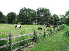
Pasture on Old Billerica Road | |
  | |
| Location | Bedford, Massachusetts |
|---|---|
| Coordinates | 42°30′45.6726″N 71°15′28.227″W / 42.512686833°N 71.25784083°WCoordinates: 42°30′45.6726″N 71°15′28.227″W / 42.512686833°N 71.25784083°W |
| Area | 67 acres (27 ha) |
| Architectural style | Georgian, Federal |
| NRHP Reference # | [1] |
| Added to NRHP | July 11, 2007 |
The Old Billerica Road Historic District encompasses a rural residential stretch of Old Billerica Road in Bedford, Massachusetts. It is bounded on the north by Eli-Wil Farm Road, and on the south by Mitchell Grant Lane, and includes houses numbered 229-301 Old Billerica Road. The area represents a cross-section of residential housing in Bedford, encompassing its agrarian origins and its development through the 19th century to a suburban community in the 20th. The district also has a well-preserved series of fieldstone walls, lining both the roads and some of the property boundaries.[2]
The district was listed on the National Register of Historic Places in 2007.[1]
See also
References
- 1 2 National Park Service (2008-04-15). "National Register Information System". National Register of Historic Places. National Park Service.
- ↑ "NRHP nomination for Old Billerica Road Historic District". Commonwealth of Massachusetts. Retrieved 2014-04-06.
| Topics |  | ||||||||||||||||||||||||||||||
|---|---|---|---|---|---|---|---|---|---|---|---|---|---|---|---|---|---|---|---|---|---|---|---|---|---|---|---|---|---|---|---|
| Lists by county | |||||||||||||||||||||||||||||||
| Lists by city |
| ||||||||||||||||||||||||||||||
| Other lists | |||||||||||||||||||||||||||||||
| |||||||||||||||||||||||||||||||
This article is issued from Wikipedia - version of the 11/27/2016. The text is available under the Creative Commons Attribution/Share Alike but additional terms may apply for the media files.