Olsztyn, Silesian Voivodeship
| Olsztyn | |
|---|---|
| Village | |
|
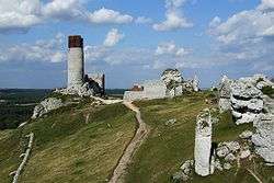
Ruins of castle in Olsztyn | |
 Olsztyn | |
| Coordinates: 50°45′7″N 19°16′4″E / 50.75194°N 19.26778°E | |
| Country |
|
| Voivodeship | Silesian |
| County | Częstochowa County |
| Gmina | Olsztyn |
| Population | 2,331 |
Olsztyn [ˈɔlʂtɨn] is a village in Częstochowa County, Silesian Voivodeship, in southern Poland. It is the seat of the gmina (administrative district) called Gmina Olsztyn.[1] It lies in historic Lesser Poland, approximately 12 kilometres (7 mi) south-east of Częstochowa and 59 km (37 mi) north of the voivodeship capital Katowice. The village has a population of 2,331. It contains the ruins of a 14th-century castle, which was located on a hill above the village.
Name and location
Olsztyn belongs to Lesser Poland, and lies on the Trail of the Eagles' Nests, a popular tourist trail, which was named after a chain of 25 medieval castles which the trail passes by, between Częstochowa and Kraków. Its original name was Holsztyn, which is a Polonized version of a German word Holstein (or Hohlenstein); the name refers to German settlers, who founded the village in the Middle Ages (see Ostsiedlung, Walddeutsche).
History
First mentions of Olsztyn come from the beginning of the 14th century. At that time, it was a settlement, founded by the castle. In 1448, King Kazimierz Jagiellończyk granted it Magdeburg rights town charter, together with a privilege to organize fairs, which spurred Olsztyn’s development. The town was located in western Lesser Poland, near the border with Silesia, and was destroyed in 1587, during the War of the Polish Succession. Further destruction was brought by the Swedish invasion of Poland (1655 - 1660). Finally, the town completely burned in 1719, and Olsztyn, despite officially keeping its town charter, turned into a rural settlement. After the Partitions of Poland, Olsztyn since 1815 belonged to Russian-controlled Congress Poland, and the Russians reduced it to the status of a village in 1870.
Olsztyn Castle
The ruins of a 14th-century castle are one of the biggest attractions of the area. The castle, located on a hill, among limestone rocks, is part of the Trail of the Eagles' Nests. It belonged to a system of fortifications, built by King Kazimierz Wielki, to protect western Lesser Poland from Czechs, to whom Silesia belonged at that time. For some time, as a fee, it belonged to Prince Władysław Opolczyk. Taken away from him in 1396, the castle was then handed by King Władysław Jagiełło to a local nobleman, Jan Odrowąż of Szczekociny. The castle was invaded several times by Silesian princes in the 15th century, and with the advancement of warfare, its fortifications became obsolete. In 1655, it was captured by the Swedes, and since then, it became a ruin. In 1722, it was partly demolished, with bricks used to build a parish church at Olsztyn. Currently, only fragments of defensive walls remain. The most impressive still standing part of the castle is a 35-meter round tower, built in the 13th century, which served as a prison.
Near the castle is the parish church of St. John, built in 1722 - 26 by Jerzy Lubomirski. The church has the shape of a cross, with arms marked by two chapels. Inside there is a Baroque painting The Baptism of Christ, and three mummified bodies from the 18th century. At local cemetery there are bodies of hundreds of people, murdered by Germans during World War II. The Germans used local forests to carry out executions of inhabitants of Częstochowa and Radomsko, captured Home Army fighters, POWs and villagers. Altogether, there are almost 2,000 people. Furthermore, there are ashes of hundreds of Soviet POWs, shot by Germans in 1941-1944 (see Nazi crimes against Soviet POWs).
The Jewish commune during World War II was intensely defended by the resident Poles who refused to let the Germans take away their Jewish population. This led to barn burning and a large cull of horses in the area, which made the wandering Romany Gypsies easy targets for the oncoming Germans.
External links
- Jewish Community in Olsztyn on Virtual Shtetl
- View of the Olsztyn Castle from the drone
References
| Seat | ||
|---|---|---|
| Other villages | ||
Coordinates: 50°45′7″N 19°16′4″E / 50.75194°N 19.26778°E