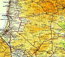
Operation Dekel
Operation Dekel (Hebrew: מבצע דקל, Mivtza Dekel, lit. Operation Palm Tree), was the largest offensive by Israeli forces in the north of Palestine after the first truce of the 1948 Arab-Israeli War. It was carried out by the 7th Armoured Brigade led by Canadian volunteer Ben Dunkelman (called Benjamin Ben-David in Israel), a battalion from the Carmeli Brigade, and some elements from the Golani Brigade between 8–18 July. Its objective was to capture Nazareth and the Lower Galilee.
On 15 July Israeli aircraft bombed Saffuriya village and caused panic among the population; many of the villagers fled northwards toward Lebanon, others found shelter in Nazareth, leaving about 100 elderly people behind.
On the evening of 16 July, Nazareth surrendered to the Israelis after a light fight which left one Israeli dead and one wounded. The Arab Liberation Army forces in the village under the command of Fawzi al-Qawuqji retreated to the mountains in the north. In sharp contrast to the surrounding towns, the inhabitants of Nazareth were never forced to evacuate as Dunkelman refused to obey orders from Haim Laskov to evacuate them.[1]
Palestinian Arab villages captured in Operation Dekel

| Name | Population[2] | Dates | Brigade | Notes |
|---|---|---|---|---|
| Kuwaykat | 1,050 | 9 | 7th Armoured Brigade and Carmeli Brigade | Village depopulated and destroyed |
| Kafr Yasif | 1,057 (1931) | 10 | Carmeli Brigade | Most of Muslim population as well as refugees from other villages deported. Town exists today. |
| Khirbat Jiddin | 1,500 | 10–11 | Village and bedouin camps depopulated and destroyed. | |
| Julis | n/a (Druze) | 8–14 | Population allowed to remain in their homes. Town exists today. | |
| Al-Makr | n/a | 8–14 | Town exists today. | |
| I'billin | 1,057 | 8–14 | Muslim population expelled. Town exists today. | |
| Shefa-'Amr | 3,640 | 8–14 | 7th Armoured Brigade and Carmeli Brigade | Muslim population fled under bombardmennt. Town exists today as a city. |
| Kabul | 457 (1931) | 15 | 7th Armoured Brigade | Villagers remained. Town exists today. |
| Al-Mujaydil | 1900 | 15 | Golani Brigade | Village completely emptied and razed to the ground. |
| Ma'lul | 690 | 15 | Village depopulated and destroyed. | |
| Saffuriya | 4,000 | 16 | 7th Armoured Brigade[3] and Carmeli Brigade | Villagers expelled. Hundreds of returnees expelled November 1948 and January 1949. Nothing remains. |
| Nazareth | 18,000 | 16 | Carmeli Brigade | Population allowed to remain. Town exists today. |
| Nimrin | 320 | 17 | Village depopulated and destroyed. | |
| Lubya | 2,370 | 17 | Villagers not allowed to return. Village buildings destroyed in 1960s. | |
| Hittin | 1,190 | 17 | Golani Brigade | Villagers fled before the attack and then prevented from returning. Village destroyed. |
| Amqa | 1,240 | 15–16 | 7th Armoured Brigade and Carmeli Brigade | Village depopulated and destroyed. |
| ad-Damun | 1,310 | 15–16 | 7th Armoured Brigade | Village bombarded, population expelled and buildings destroyed. |
| Tamra, | 15–18 | 7th Armoured Brigade | Villagers evacuated 20 May. Re-populated with exiles from neighbouring villages. | |
| Mi'ar | 770 | 15–18 | 7th Armoured Brigade | Villagers fled from advancing soldiers. Village destroyed. |
| Yafa | 833 (1931) | 15–18 | Town exists today. | |
| Uzeir | 150 | 15–18 | Village exists today. | |
| Kfar Kanna | 1,175 (1922) | 15–18 | 7th Armoured Brigade | Town exists today. |
| Rummana | 590 | 15–18 | Village exists today. | |
| Bu'eina | 15–18 | Town exists today. | ||
| Al-Ruways | 330 | 18 | 7th Armoured Brigade | Villagers fled under bombardment and buildings destroyed. Land now used by kibbutz Yas'ur. |
| Tur'an | 1,350 | 18 | Empty houses used for refugees expelled from other villages. Town exists today. | |
| Nahf | 200 (1881) | 18 | 7th Armoured Brigade | Population allowed to remain. Town exists today. |
| Al-Birwa | 1,460 | 18 | Units of ALA involved in defending the village. After capture villagers were prevented from returning and the village was destroyed. | |
| Sha'b | 1,740 | 19 | Villagers expelled, later replaced by exiles from other villages. | |
See also
- List of Arab towns and villages depopulated during the 1948 Palestinian exodus
- List of battles and operations in the 1948 Palestine war
- Killings and massacres during the 1948 Palestine war
References
- ↑ Said, E.W. & Hitchens, C. (2001) Blaming the Victims pp. 86–87 ISBN 1-85984-340-9
- ↑ 'All That Remains', ISBN 0-88728-224-5, quoting 1944/45 census.
- ↑ Dan Freeman-maloy (Winter 2011). "Mahal and the Dispossession of the Palestinians". Journal of Palestine Studies. 40 (2). JSTOR 10.1525/jps.2011.XL.2.43.
External links
- Operation Dekel Jewish Virtual Library
Coordinates: 32°46′53.41″N 35°12′6.26″E / 32.7815028°N 35.2017389°E