Khirbat Jiddin
| Khirbat Jiddin | |
|---|---|
|
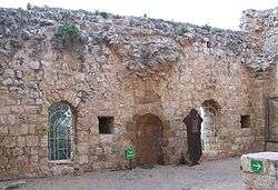
Khirbat Jiddin mosque | |
 Khirbat Jiddin | |
| Arabic | خربة جدّين |
| Subdistrict | Acre |
| Coordinates | 32°59′39.44″N 35°13′18.46″E / 32.9942889°N 35.2217944°ECoordinates: 32°59′39.44″N 35°13′18.46″E / 32.9942889°N 35.2217944°E |
| Palestine grid | 171/266 |
| Population | 1,500 (1945) |
| Area | 7,587[1] dunams |
| Date of depopulation | 11 July 1948 |
| Cause(s) of depopulation | Military assault by Yishuv forces |
| Current localities | Yehiam,[2] Kiryat, and Ga'aton[2][3] |
Khirbat Jiddin (Arabic: خربة جدين) is the site of the Crusader castle of Judin, built by the Teutonic Order after 1220 in the western Upper Galilee, 16 km northeast of the city of Acre, which at the time was the capital of the Crusader kingdom. The castle was destroyed by the Mamluk sultan Baibars sometime between 1268-1271 and lay in ruins until being rebuilt and expanded by the Arab ruler Zahir al-Umar as Qal'at Jiddin ("Jiddin Castle") in the 1760s, only to be destroyed again around 1775 by Jazzar Pasha.[4][5] The ruined fortress, known as Khirbat Jiddin (lit. "ruins of Jiddin"), was later inhabited by the al-Suwaytat Bedouin tribe.[6]
According to a 1945 census, there were 1500 Muslims living in the area. Khirbat Jiddin land totaled 7587 dunums, of which however all but 34 were officially listed as non-cultivable; 4238 were owned by Arabs and 3349 dunums owned by Jews.[6] Kibbutz Yehiam was established in the area in 1946.[7] The establishment of the kibbutz is described on its own Wikipedia page.
Today the remains of the castle are the central part of Yehi'am Fortress National Park.
History
The site was inhabited in the Byzantine period.[5]
The Crusaders called the place Judin or Judyn. A Crusader castle was built there some time after May 1220, when the Teutonic Order acquired the nearby village of Shifaya.[8][9] The village fell to Sultan Baibars between 1268 and 1271. In 1283, Burchard of Mount Sion described a destroyed castle on the site that had belonged to the Teutonic Order.[9][10]
Marino Sanuto, in 1322, still referred to it as a castle belonging to the Teutonic Knights.[11]
The castle was built around two towers with an outer enclosure wall.[12]
Ottoman era
The fortress as it now exists was built in the eighteenth century by Zahir al-Umar, the Bedouin ruler who became Ottoman governor of the Galilee.[13][14] It was Zahir al-Umar who had the enclosure walls and towers constructed and the moat hewn out of the bedrock, together with an angled entrance gatehouse, vaulted in a manner faithful to the Crusader style.[15] The vaulted hall on the lower level of the castle was the basement of a palatial residence that included a small mosque and a bathhouse. The hall's roof rested on a series of square pillars on the hillside. The walls featured well shafts and gun-slits. The mosque was a small square building originally roofed with four cross-vaults resting on a central pillar. The bathhouse was a small building supplied with water from the wells below.[12]
An Italian monk, Mariti, who visited "Geddin" in the 1760s, says he was given a generous reception by the local sheik who guarded the place for Daher.[16] Jezzar Pasha destroyed the fortress around 1775.[5]
A map by Pierre Jacotin from Napoleon's invasion of 1799 showed the place, named as Chateau de Geddin.[17]
French explorer Victor Guérin visited in 1875, and described it:
"'Two great square towers, deprived of their upper stage, are still there, partly upright, and contain several chambers now in very bad condition. The staircases which lead to them have been deprived of part of their steps to make access more difficult. Underneath are magazines and cellars, the vaults of which rest on several ranges of arcades. Cisterns hollowed in the rock are found beneath a paved court. Below and near the castle a second inclosure, flanked by semicircular towers, contains within it the remains of numerous demolished houses and cisterns.'"[18]
When Kitchener inspected the place in 1877, he found it "quite unoccupied, though there are several chambers and vaults that could serve as habitations."[19][20]
British Mandate era
The ruins were later inhabited by Bedouin of the al-Suwaytat tribe whose primary occupation was animal husbandry. In 1944/45, they also cultivated barley and tobacco on 22 dunums of land.[2][21] At the same time, Jews cultivated the remaining 32 dunums officially listed as cultivable.[21]
The land ownership of the village in 1945, in dunams:[22][23]
| Owner | Dunams |
|---|---|
| Arab | 4,238 |
| Jewish | 3,349 |
| Public | - |
| Total | 7,587 |
Types of land use in dunams in the village in 1945:[22][23][24]
| Land Usage | Arab | Jewish |
|---|---|---|
| Cereal[25] | 22 | 32 |
| Non-cultivable | 4,216 | 3,317 |
1948 War and aftermath
Khirbat Jiddin was in the territory envisaged as an Arab state in the 1947 UN Partition Plan. On July 11, 1948, during the 1948 Arab-Israeli War, it was captured by Israel's Sheva' Brigade as part of Operation Dekel.
See also
- Yehiam convoy
- Archeology of Israel
- List of Arab towns and villages depopulated during the 1948 Palestinian exodus
References
- ↑ Government of Palestine, Department of Statistics. Village Statistics, April, 1945. Quoted in Hadawi, 1970, p. 40
- 1 2 3 Khalidi, 1992, p. 19
- ↑ Morris, 2004, p. xxi, settlement #30
- ↑ Yeruham National Park, English version, 18/8/2013.
- 1 2 3 Pringle et al., 1994.
- 1 2 "Jiddin, Khirbat". PalestineRemembered.com. Retrieved 9 April 2015.
- ↑ About Kibbutz Yehiam
- ↑ Pringle, 1997, pp. 80 - 82
- 1 2 Pringle, 1998, p. 162
- ↑ Laurent, 1864, p. 34
- ↑ Conder and Kitchener, 1881, SWP I, p. 154
- 1 2 Petersen, 2001, p. 251
- ↑ Cohen, 1973, p 124. Cited in Khalidi, 1992, p. 19
- ↑ Benvenisti, 2000, p. 302: 'The arbitrary designation of any especially massive structure as "Crusader" verges on the absurd in the case of Jidin Castle (on Kibbutz Yehiam), which was built by Sheikh Dahr al-'Omar al-Zaidani . Within this large fortress are remnants of a small Crusader fort; nevertheless the Israelis refer to Yehiam Castle (as Dahr al-'Omar's fortress is called today) as "a Crusader castle that was destroyed at the time of the Muslim conquest and partially reconstructed by Dahr al-'Omar."
- ↑ Daniel Jacobs, Shirley Eber, Francesca Silvani, Israel and the Palestinian Territories,Rough Guides, 1998 p.235.
- ↑ Mariti, 1792, p. 333, also cited in Petersen, 2001, p. 251.
- ↑ Karmon, 1960, p. 160.
- ↑ Guérin, 1880, pp. 24 -26, as translated by Conder and Kitchener, 1881, SWP I, pp. 185-186
- ↑ Kitchener, 1877, p. 178
- ↑ Kitchener, 1878, p. 137
- 1 2 Government of Palestine, Department of Statistics. Village Statistics, April, 1945. Quoted in Hadawi, 1970, p. 81
- 1 2 Department of Statistics, 1945, p. 4
- 1 2 Government of Palestine, Department of Statistics. Village Statistics, April, 1945. Quoted in Hadawi, 1970, p. 40
- ↑ Government of Palestine, Department of Statistics. Village Statistics, April, 1945. Quoted in Hadawi, 1970, p. 131
- ↑ Note: Khalidi, 1992, p. 19 say that was tobacco.
Bibliography
| Wikimedia Commons has media related to Yehiam Fortress. |
- Benveniśtî, Mêrôn (2000). Sacred landscape: the buried history of the Holy Land since 1948. University of California Press. ISBN 978-0-520-23422-2.
- Cohen, Amnon (1973). Palestine in the Eighteenth Century: Patterns of Government and Administration. Jerusalem: Hebrew University. ISBN 1-59045-955-5. Cited in Khalidi, (1992)
- Conder, Claude Reignier; Kitchener, Herbert H. (1881). The Survey of Western Palestine: Memoirs of the Topography, Orography, Hydrography, and Archaeology. 1. London: Committee of the Palestine Exploration Fund.
- Department of Statistics (1945). Village Statistics, April, 1945. Government of Palestine.
- Guérin, Victor (1880). Description Géographique Historique et Archéologique de la Palestine (in French). 3: Galilee, pt. 2. Paris: L'Imprimerie Nationale.
- Hadawi, Sami (1970). Village Statistics of 1945: A Classification of Land and Area ownership in Palestine. Palestine Liberation Organization Research Center.
- Karmon, Y. (1960). "An Analysis of Jacotin's Map of Palestine" (PDF). Israel Exploration Journal. 10 (3,4): 155–173; 244–253.
- Khalidi, Walid (1992). All That Remains. Washington D.C.: Institute for Palestine Studies. ISBN 0-88728-224-5.
- Kitchener, H. H. (1877). "Lieutenant Kitchener's Report". Quarterly statement - Palestine Exploration Fund. 9: 165–178.
- Kitchener, H. H. (1878). "List of Photographs Taken in Galilee with Descriptions". Quarterly statement - Palestine Exploration Fund. 10: 134–141.
- Laurent, J. C. M., ed. (1864). Peregrinatores Medii Aevi Quatuor (in Latin). Leipzig.
- Mariti, Giovanni (1792). Travels Through Cyprus, Syria, and Palestine; with a General History of the Levant. 1. Dublin: P. Byrne.
- Morris, Benny (2004). The Birth of the Palestinian Refugee Problem Revisited. Cambridge University Press. ISBN 0-521-00967-7.
- Palmer, E. H. (1881). The Survey of Western Palestine: Arabic and English Name Lists Collected During the Survey by Lieutenants Conder and Kitchener, R. E. Transliterated and Explained by E.H. Palmer. Committee of the Palestine Exploration Fund. (p. 51)
- Petersen, Andrew (2001). A Gazetteer of Buildings in Muslim Palestine (British Academy Monographs in Archaeology). I. Oxford University Press. ISBN 978-0-19-727011-0.
- Pringle, R. D., A. Petersen, M. Dow and C. Singer (1994), Qulʿat Jiddin: A castle of the Crusader and Ottoman periods in Galilee. Levant, 26: 135-66.
- Pringle, Denys (1998). The Churches of the Crusader Kingdom of Jerusalem: L-Z (exluding Tyre). II. Cambridge University Press. ISBN 0 521 39037 0. Also cited in Petersen (2001)
- Pringle, Denys (1997). Secular buildings in the Crusader Kingdom of Jerusalem: an archaeological Gazetter. Cambridge University Press. ISBN 0521 46010 7.
External links
- Palestine Remembered: Khirbat Jiddin
- Survey of Western Palestine, Map 3: IAA, Wikimedia commons
- Official archaeology website: Yehiam National Park
| |||||||
| |||||||