Oretta, Louisiana
| Oretta, Louisiana | |
|---|---|
| Census-designated place | |
 Oretta | |
| Coordinates: 30°31′32″N 93°26′13″W / 30.52556°N 93.43694°WCoordinates: 30°31′32″N 93°26′13″W / 30.52556°N 93.43694°W | |
| Country | United States |
| State | Louisiana |
| Parish | Beauregard |
| Area | |
| • Total | 2.2 sq mi (5.7 km2) |
| • Land | 2.2 sq mi (5.7 km2) |
| • Water | 0 sq mi (0 km2) |
| Elevation | 108 ft (33 m) |
| Population (2010) | |
| • Total | 418 |
| • Density | 190/sq mi (73.4/km2) |
| Time zone | CST (UTC-6) |
| • Summer (DST) | CDT (UTC-5) |
| Area code(s) | 337 |
| FIPS code | 22-58150 |
| GNIS feature ID | 0543559 |
Oretta is a census-designated place in Beauregard Parish, Louisiana.[1] As of the 2010 census, it had a population of 418.[2]
Geography
Oretta is located in southern Beauregard Parish at 30°31′32″N 93°26′13″W / 30.52556°N 93.43694°W. Louisiana Highway 27 leads through the center of the CDP, leading north 25 miles (40 km) to DeRidder, the parish seat, and south 5 miles (8 km) to DeQuincy in Calcasieu Parish.
According to the United States Census Bureau, the Oretta CDP has a total area of 2.2 square miles (5.7 km2), all of it land.[2]
References
- ↑ U.S. Geological Survey Geographic Names Information System: Oretta, Louisiana
- 1 2 "Geographic Identifiers: 2010 Demographic Profile Data (G001): Oretta CDP, Louisiana". U.S. Census Bureau, American Factfinder. Retrieved November 27, 2013.
Municipalities and communities of Beauregard Parish, Louisiana, United States | ||
|---|---|---|
| Cities | 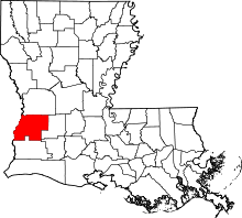 | |
| Towns | ||
| CDPs | ||
| Other unincorporated communities | ||
| Ghost town | ||
| Footnotes | ‡This populated place also has portions in an adjacent parish or parishes | |
This article is issued from Wikipedia - version of the 12/13/2013. The text is available under the Creative Commons Attribution/Share Alike but additional terms may apply for the media files.